Begumganj Upazila
Begumganj (Bengali: বেগমগঞ্জ) is an Upazila of Noakhali District[1] in the Division of Chittagong, Bangladesh. Begumganj Thana now an Upazila was Established in 1892.
Begumganj বেগমগঞ্জ | |
|---|---|
Upazila | |
 Begumganj Location in Bangladesh | |
| Coordinates: 22°57′N 91°6′E | |
| Country | |
| Division | Chittagong Division |
| District | Noakhali District |
| Area | |
| • Total | 238.37 km2 (92.04 sq mi) |
| Population (2011) | |
| • Total | 549,308 |
| • Density | 1,587/km2 (4,110/sq mi) |
| Time zone | UTC+6 (BST) |
| Website | begumganj |
Geography
Begumganj is located at 22.9500°N 91.1000°E . It has 118361 households and total area 426.05 km².
Demographics
As of the 2011 Bangladesh census, Begumganj has a population of 549,308. Males constitute 49.2% of the population, and females 50.8%. This Upazila's eighteen up population is 313911. Begumganj has an average literacy rate of 44.4% (7+ years), and the national average of 32.4% literate.[2]
Administration
Begumganj has 16 Unions/Wards, 344 Mauzas/Mahallas, and 343 villages.chairman
Education Institutions in Begumganj Upazila
College's in Begumganj Upazila
School's in Begumganj Upazila
- Begumganj Government Pilot High School
- Chowmuhani Modon Mohon High School
- Jamidar Hat B.N. High School
- Gonipur Pilot Girls' High School
- Rajganj Union High School
- Chhayani High School
- Chhayani Girls High School
See also
- Upazilas of Bangladesh
- Districts of Bangladesh
- Divisions of Bangladesh
References
- Sultan Mahmud Bhuiyan (2012), "Begumganj Upazila", in Sirajul Islam and Ahmed A. Jamal (ed.), Banglapedia: National Encyclopedia of Bangladesh (Second ed.), Asiatic Society of Bangladesh
- "Population Census Wing, BBS". Archived from the original on 2005-03-27. Retrieved November 10, 2006.
| Upazila/Thana: | ||
|---|---|---|
Capital: Chattogram | ||
| Bandarban District | 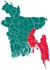 | |
| Brahmanbaria District | ||
| Chandpur District | ||
| Chattogram District | ||
| Cumilla District |
| |
| Cox's Bazar District | ||
| Feni District | ||
| Khagrachari District |
| |
| Lakshmipur District | ||
| Noakhali District | ||
| Rangamati District | ||
This article is issued from Wikipedia. The text is licensed under Creative Commons - Attribution - Sharealike. Additional terms may apply for the media files.