Panchagarh District
Panchagarh (Bengali pronunciation: [pɔntʃoɡɔɽ]; Bengali: পঞ্চগড়, Panchagaṛ "five forts") is a district of the Rangpur division in Northern Bangladesh.
Panchagarh পঞ্চগড় | |
|---|---|
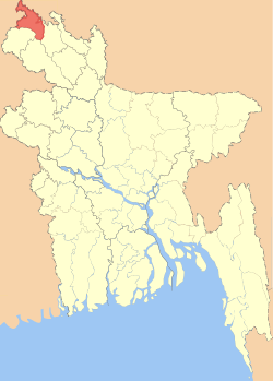 Location of Panchagarh District in Bangladesh | |

Expandable map of Panchagarh District | |
| Coordinates: 26.2°N 88.34°E | |
| Country | |
| Division | Rangpur Division |
| Area | |
| • Total | 1,404.62 km2 (542.33 sq mi) |
| [1] | |
| Population (2011 census) | |
| • Total | 987,644 |
| • Density | 700/km2 (1,800/sq mi) |
| Literacy rate | |
| • Total | 51.08% (male 55.2%, female 48.3%) |
| Time zone | UTC+06:00 (BST) |
| Postal code | 5000 |
| HDI (2018) | 0.614[2] medium · 7th of 21 |
| Constituencys | Panchagarh-1 Panchagarh-2 |
| Website | www |
Toponym History
Panchagarh was first known as Pachagarh. There are two main beliefs associated with the name of the district. The first is that Panchargarh was named after an area called Pancha Nagari in the kingdom of Pundu Nagar. The second is that it was named for the five forts (or garhs) in the region. The forts were Bhitargarh, Hosaingarh, Mirgarh, Rajangarh and Devengarh. Hence, the name Panchagarh, meaning 'five forts'.
History
After the Partition of India and Pakistan in 1947, Panchagarh was a thana under the Thakurgaon mahakuma. On 1 January 1980, it was established as a mahakuma consisting of 5 thanas named Tetulia, Panchagarh Sadar, Atwari, Boda and Debiganj. The first commissioner of Panchagarh was Sayed Abdur Rashid from 1 January 1980 to 31 December 1982. Later, it was established as a district on 1 February 1984. The first deputy commissioner of Panchagarh was A. S. M. Abdul Halim from 1 February 1984 to 16 June 1985.[3]
Geography
Panchagarh is located in the extreme north of Bangladesh, and is bounded on three sides by the 288 km long Indian border, with the Darjeeling district on the north, Jalpaiguri and Cooch Behar districts on the northeast, Uttar Dinajpur on the west, Dinajpur and Thakurgaon districts on the south, and Nilphamari district on the east.
Its soil is sandy, alluvial and bears close affinity with the soil of the old Himalayan basin. On the northern part of the district there exists an underground layer of pebbles. It is 150 feet (46 m) high from the sea level. Panchagarh has 16 rivers. Among them some main rivers are Karatoya (Karatoa), Atrai, Teesta, Nagor, Mahananda, Tangon, Dahuk, Pathraj, Bhulli, Talma, Chawai, Kurum, Tirnoi, and Chilka. It is 150 feet (46 m) high from the level. The border of this district was designed by Sir Cyril John Radcliffe in 1947. The length of the border in Panchagarh between Bangladesh and India is 286.87 km.[4]
| Description | 2011 | 2001 | % of national |
|---|---|---|---|
| Area (km2) | 1,404.62 | 1,404.63 | 0.96 |
| Population | 10,26,141 | 836,196 | 0.71 |
| Description | 2011 | 2001 | 1991 | % change |
|---|---|---|---|---|
| Density | 703 | 595 | 507 | 17.36 |
| Literacy rate | 71.8 | 40.82 | 27.80 | 46.83 |
- Total boundary: 302.68 km
- Established: 01.02.1984
- No. of city corporations: 2
- No. of upzillas: 5
- No. of unions: 43
- No. of villages: 825
- No. of mouzas: 463
- Rate of education:
- Men: 42%
- Women: 24%
- No. of rivers: 16
- Main rivers: Korotoya, Dahuk, Chawai, Tirnoy
- Rivers: Panchagarh has 23 rivers. Among them some main rivers are Karatoya, Atrai, Tista, Nagor, Mahananda, Tangon, Dahuk, Pathraj, Bhulli, Talma, Chawai, Kurum, Versa, Tirnoi, and Chilka.
Economy

Industry: Tea, sugar, rice mill, ice factory, garment factory, oil mill, and saw mill.
Banglabandha land port is located in about 10 acres (40,000 m2) of acquired land at the north-western tip of Bangladesh in Tetulia under Panchagarh district on the Bangladesh-India highway. The port is situated 60 km from Panchagarh Town. The place is of international character and used for Nepal transit traffic passing through a small corridor of India. It is about 22 meters away from the Bangladesh-Indian border.
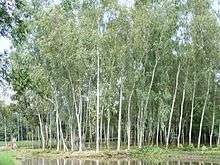
The growing tea sector in Panchagarh has ushered in a new hope for further enhancing the standard of socio-economic life and empowering women. The female workers are yet to get fair wages from the garden-owners as the growing tea-farming sector in the region has been facing manifold problems including unfair prices of the tea leaves for the tea farmers. Presently, over 7,000 skilled and unskilled workers, mostly women, have been working in 246 tea gardens, including 18 big estates, 13 medium-size and 215 small-scale gardens set up on more than 1,815 acres (7.35 km2) of land in Tetulia and its surrounding areas. Of them nearly 2,300 workers, mostly women, are working alone at the giant Kazi and Kazi Tea Estate (KKTE) at Tetulia which has earned reputation in both national and international markets by producing, processing and marketing the famous and most popular Kazi & Kazi organic tea and earning foreign exchange.
Industry for manufacturing SPC electric poles, established a plant (Gemcon Ltd.) over a land of 35 acres in Panchagarh District. Here, all the products in the plant are manufactured by using indigenous raw materials. The factory has created direct or indirect job opportunity for more than 1500 people and helping the nation in poverty alleviation.
Gem Jute Limited was established in Panchagarh in 2003, with the corporate vision is to improve the livelihood of the local population by providing employment and advancement opportunities, stimulate the local economy through direct and indirect economic activities. Gem Jute promotes sustainable development and support the environment by providing high-quality, organic, biodegradable products to the world market. Over 5000 people are working at Gem Jute Limited.
Under Bangladesh Sugar and Food Industries Corporation (BSFIC), Panchagarh Sugar Mills Ltd. is the oldest industry of the district. Panchagarh Sugar Mills was set up by the Government in 1965–69 at a cost of Tk.55.55 million. It is near the district headquarters of Panchagarh and is the northernmost sugar mill in Bangladesh. Machinery and equipment of the sugar mill were supplied by M/S. Stork Werkspoor of Holland. The sugar mill started its trial production in 1969–70. Since independence of Bangladesh (until 2005), the sugar mill has produced 8,536 m. tons of sugar per annum on average at an average sugar recovery rate of 8.10% from sugarcane.
Festivals
During the festival of Pohela Boishakh (the first day of the Bengali year), the whole community celebrates with coloured water (similar to Holi in INsia
Points of Interest
Atwari
Atwari, a popular tourist spot, has three domed mosques at Mirzapur, Chhaprajhar (Pahar Bhanga) and Sardarpara, which bear the relics of Mughal architecture and the remains of the Zamindar Bari of Aloakhoa. The Bara Awliyar Majar is another notable place of interest.
Atwari has the marks of Bangladesh War of Liberation of 1971. There are 2 mass graves, 1 twin grave and 1 martyr memorial monument.
Tetulia
Tetulia is a hospitality hub for tourists. It has a "Daak Banglo" situated on the bank of river Mahananda facing Darjeeling. Tea of Tetulia has same quality like tea of Darjeeling. The "Kazi & Kazi" tea garden, the "Tetulia Tea" garden, the Banglabandha land port are the attractive places for the visitors.
Remnants of a fort at a place named 'Buraburi' between Bhajanpur and Tetulia. Also Bhadreswar temple and Shiva-temple are the two tombstones of the Greek sculptural. It has Bhadreswar Temple, Vitorgarh.
Panchagarh Sadar
Maharaja Dighi (Pond) at Bhitargarh is a well known tourist attraction in the Sadar Upazila. Bhitrar Shalmara is a notable lake. Shal forest of Bhitargarh and the government forest on the banks of the Chawai and Karatôya rivers are also quite famous
During the War of Liberation in 1971, the guerrilla fighters demolished the bridge on the Chawai near the Amarkhana camp thereby obstructing the advance of the Pakistani army towards the north. At the initial stage of the war, Maqbul Darji & the Badi Howladar (EPR) were killed in an encounter with the Pakistani army, which lost eighteen of its soldiers.
The 'Shaheed Farooque Ahmad Memorial Monument' at Dhakka-mara in Panchagarh town is the mark of war of liberation. Also the grave of the martyr freedom fighter Sakimuddin at Jagdal-hat in front of the Baital Aman mosque is another Mark of the war.

Boda
The Vadeswari mosque, Vadeswari temple and Govinda temple are famous tourist attractions in Boda.
Debiganj
In Debiganj, the Revenue office building and the old residential house of the Raja of Cooch-Bihar are quite well-known. Jagabandhu Thakur-bari is another place of interest for tourists, Saldanga Gokulam Temple which is notable for its Greek architecture is located in Debiganj. The town has one Dak Bungalow (Rest house).
Administration
Panchagarh has five upazilas:
| Upazila | Population (2011)[5] |
|---|---|
| Panchagarh Sadar | 271707 |
| Debiganj | 224709 |
| Boda | 232124 |
| Atwari | 133650 |
| Tetulia | 125454 |
- Administrator of Zila Porishod: Abu Bakar Siddique[6]
- Deputy Commissioner (DC): Muhammad Salah Uddin[7]
Members of tenth Jatiyo Sangsad
The members of the tenth Jatiyo Sangsad, elected 2019 are:[8]
- Panchagarh-1: Mozaharul Haque Prodhan (from Awami League)
- Panchagarh-2: Nurul Islam Sujon (from Awami League)
Transport
Bicycle, rickshaw, motor cycle are the main modes of transport for the local people. Regular buses connect the district to their neighbouring districts and subdivisions. The road distance from Dhaka (Capital city of Bangladesh) to Panchagarh is 475 km. Road transportation between Dhaka and Panchagarh is a private sector affair, operating predominantly in domestic routes. On 10 November 2018, direct train service from Dhaka to Panchagarh was inaugurated. The railway distance from Dhaka to Panchagarh is 639 km, which is the longest distance travelled by any train in the country. There is no direct air connection from Dhaka to Panchagarh.[9]
Education
B.P (Bishnu Prasad) Govt. A High school, which is located near Panchagarh town, is the biggest and the most famous boys' school of Panchagarh. The S.S.C examination (public exam) result of the school is very good. In 2009, 85 students of this school secured GPA 5 in the SSC examination. The school also stood 9th in Bangladesh. In the 2015 JSC exam, 16 students got talent pool scholarships, which is rarely awarded in Bangladesh. Panchagarh Govt. Girls' High School, which is situated at the heart of the Panchagarh Town, is the most famous girls' school in the district. In the 2008 S.S.C examination, 32 students of this school got GPA 5 in the SSC examination. M.R (Moqbular Rahman) Govt. College is the biggest and most famous men's college of Panchagarh whereas Panchagarh Govt. Women's college is the most famous women's college of the district. N.N (Nripandra Narayan) Govt. High School and Debiganj Alodini Govt. Girls' High School are located in the Debiganj Upazila. Notable places
- Bhitarganj
- Maharajar Dighi
- Badeshwari Mahapith Temple
- Mirjapur Shahi Mosque
- Golok Dham Temple
- Banglabandha zero point and land port
- Tetulia Dak Banglo
- Rocks Museum[10]
Notable residents
- Muhammad Jamiruddin Sarkar, former speaker, Jatiyo Sangshad
- Mirza Ghulam Hafiz, former Minister of Law and Justice, Jatiyo Sangshad
- Sirajul Islam, Member of Parliament, Jatiyo Sangshad
- Mohammad Sultan, language movement activist in 1952
- Mohammad Farhad, Captain of Guerilla force in the 1971 independence war and member of the parliament of national parliament
- Abdur Rahman, film actor[11]
- Shoriful Islam, Bangladeshi cricketer
- Md. Nurul Islam Sujon, Railway Minister of Bangladesh
See also
- Districts of Bangladesh
- Rangpur Division
- Dinajpur Board, Bangladesh
References
- Md Sherozzaman (2012). "Panchagarh District". In Sirajul Islam and Ahmed A. Jamal (ed.). Banglapedia: National Encyclopedia of Bangladesh (Second ed.). Asiatic Society of Bangladesh.
- "Sub-national HDI - Area Database - Global Data Lab". hdi.globaldatalab.org. Retrieved 2020-03-18.
- "Background of District".
- "Geography of Panchagarh".
- "Community Report Panchagarh Zila June 2012" (PDF). Bangladesh Bureau of Statistics. Archived from the original (PDF) on 15 November 2012. Retrieved 1 April 2013.
- "AL men appointed administrators". thedailystar.net. Retrieved 29 October 2015.
- "Archived copy". Archived from the original on 22 December 2011. Retrieved 22 December 2011.CS1 maint: archived copy as title (link)
- Super User. "List of 10th Parliament Members English". parliament.gov.bd. Retrieved 29 October 2015.
- "Transport system of district".
- "Tradition of district".
- "Notable residents of Panchagarh".
External links
| Wikimedia Commons has media related to Panchagarh District. |
বাংলাপিডিয়া, মির্জা গোলাম হাফিজ
জেলা তথ্য বাতায়ন, পঞ্চগড়।
