Sablan, Benguet
Sablan, officially the Municipality of Sablan, (Ilocano: Ili ti Sablan; Tagalog: Bayan ng Sablan), is a 5th class municipality in the province of Benguet, Philippines. According to the 2015 census, it has a population of 11,457 people.[4]
Sablan | |
|---|---|
| Municipality of Sablan | |
 | |
 Seal | |
 Map of Benguet with Sablan highlighted | |
OpenStreetMap 
| |
.svg.png) Sablan Location within the Philippines | |
| Coordinates: 16°30′N 120°31′E | |
| Country | |
| Region | Cordillera Administrative Region (CAR) |
| Province | Benguet |
| District | Lone District |
| Barangays | 8 (see Barangays) |
| Government | |
| • Type | Sangguniang Bayan |
| • Mayor | Manuel B. Munar Jr. |
| • Vice Mayor | Arthur C. Baldo |
| • Congressman | Nestor B. Fongwan |
| • Electorate | 7,603 voters (2019) |
| Area | |
| • Total | 105.63 km2 (40.78 sq mi) |
| Elevation | 599.9 m (1,968.2 ft) |
| Population (2015 census)[4] | |
| • Total | 11,457 |
| • Density | 110/km2 (280/sq mi) |
| • Households | 2,599 |
| Economy | |
| • Income class | 5th municipal income class |
| • Poverty incidence | 6.75% (2015)[5] |
| • Revenue (₱) | 63,120,567.12 (2016) |
| Time zone | UTC+8 (PST) |
| ZIP code | 2614 |
| PSGC | |
| IDD : area code | +63 (0)74 |
| Climate type | tropical rainforest climate |
| Native languages | Kankanaey language Ibaloi Ilocano Tagalog |
Etymology
The term "Sablan" was derived from the local word "Sabdang", a local tree which thrived in the area.[6]
History
Sablan was created officially as a municipal district on July 1, 1927 under Executive Order No. 61 dated May 17, 1927 by then American Governor General Leonard Wood.
Geography
Sablan is at the mid-western tip of Benguet. It is bounded by Kapangan on the north, Tublay on the northeast, La Trinidad on the east, Baguio City in the southeast, Tuba in the south, Aringay on the southwest, and Burgos to the west.
According to the Philippine Statistics Authority, the municipality has a land area of 105.63 square kilometres (40.78 sq mi) [2] constituting 3.81% of the 2,769.08-square-kilometre- (1,069.15 sq mi) total area of Benguet.
Barangays
Sablan is politically subdivided into 8 barangays.[7]
| PSGC | Barangay | Population | ±% p.a. | |||
|---|---|---|---|---|---|---|
| 2015[4] | 2010[8] | |||||
| 141112002 | Bagong | 6.2% | 705 | 764 | −1.52% | |
| 141112003 | Balluay | 4.7% | 536 | 507 | 1.06% | |
| 141112004 | Banangan | 15.8% | 1,808 | 1,756 | 0.56% | |
| 141112005 | Banengbeng | 9.4% | 1,072 | 1,108 | −0.63% | |
| 141112006 | Bayabas | 21.5% | 2,467 | 2,068 | 3.42% | |
| 141112007 | Kamog | 12.8% | 1,468 | 1,064 | 6.32% | |
| 141112010 | Pappa | 5.2% | 593 | 594 | −0.03% | |
| 141112011 | Poblacion | 24.5% | 2,808 | 2,650 | 1.11% | |
| Total | 11,457 | 10,511 | 1.65% | |||
Climate
| Climate data for Sablan, Benguet | |||||||||||||
|---|---|---|---|---|---|---|---|---|---|---|---|---|---|
| Month | Jan | Feb | Mar | Apr | May | Jun | Jul | Aug | Sep | Oct | Nov | Dec | Year |
| Average high °C (°F) | 22 (72) |
23 (73) |
24 (75) |
25 (77) |
24 (75) |
23 (73) |
21 (70) |
21 (70) |
21 (70) |
22 (72) |
23 (73) |
22 (72) |
23 (73) |
| Average low °C (°F) | 12 (54) |
12 (54) |
14 (57) |
16 (61) |
17 (63) |
16 (61) |
16 (61) |
16 (61) |
16 (61) |
15 (59) |
14 (57) |
12 (54) |
15 (59) |
| Average precipitation mm (inches) | 15 (0.6) |
16 (0.6) |
24 (0.9) |
33 (1.3) |
102 (4.0) |
121 (4.8) |
177 (7.0) |
165 (6.5) |
144 (5.7) |
170 (6.7) |
56 (2.2) |
23 (0.9) |
1,046 (41.2) |
| Average rainy days | 6.3 | 6.6 | 9.5 | 12.8 | 20.6 | 23.5 | 25.4 | 23.4 | 23.2 | 21.4 | 14.0 | 8.2 | 194.9 |
| Source: Meteoblue [9] | |||||||||||||
Demographics
| Population census of Sablan | |||||||||||||||||||||||||||||||||||||||||||
|---|---|---|---|---|---|---|---|---|---|---|---|---|---|---|---|---|---|---|---|---|---|---|---|---|---|---|---|---|---|---|---|---|---|---|---|---|---|---|---|---|---|---|---|
|
| ||||||||||||||||||||||||||||||||||||||||||
| Source: Philippine Statistics Authority[4][8][10][11] | |||||||||||||||||||||||||||||||||||||||||||
In the 2015 census, Sablan had a population of 11,457.[4] The population density was 110 inhabitants per square kilometre (280/sq mi).
Education
Public schools
As of 2014, Sablan has 14 public elementary schools and 2 public secondary schools.[12][13][14]
|
|
Private schools
Saint Louis School of Sablan is the only private secondary school in the municipality, located at barangay Poblacion.
Transportation
Major roads within the Sablan include the Naguilian Road (formerly Quirino Highway) and Asin–Nangalisan–San Pascual Road.
Gallery
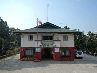 Municipal hall
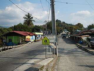 Downtown Sablan
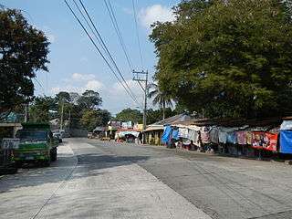 Fruit and souvenir stalls along Naguilian Road
 Immaculate Conception Parish Church
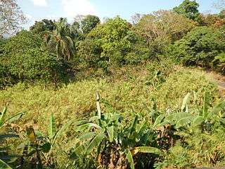 Rural landscape
References
- "Municipality". Quezon City, Philippines: Department of the Interior and Local Government. Retrieved 31 May 2013.
- "Province: Benguet". PSGC Interactive. Quezon City, Philippines: Philippine Statistics Authority. Retrieved 12 November 2016.
- "Sablan, Benguet Profile". PhilAtlas.com. Retrieved 15 June 2020.
- Census of Population (2015). "Cordillera Administrative Region (CAR)". Total Population by Province, City, Municipality and Barangay. PSA. Retrieved 20 June 2016.
- "PSA releases the 2015 Municipal and City Level Poverty Estimates". Quezon City, Philippines. Retrieved 12 October 2019.
- "Municipality of Sablan, Benguet profile". DILG - CAR. Department of Interior and Local Government (Philippines). Retrieved 16 September 2014.
- "Municipal: Sablan, Benguet". PSGC Interactive. Quezon City, Philippines: Philippine Statistics Authority. Retrieved 8 January 2016.
- Census of Population and Housing (2010). "Cordillera Administrative Region (CAR)". Total Population by Province, City, Municipality and Barangay. NSO. Retrieved 29 June 2016.
- "Sablan: Average Temperatures and Rainfall". Meteoblue. Retrieved 21 March 2020.
- Censuses of Population (1903–2007). "Cordillera Administrative Region (CAR)". Table 1. Population Enumerated in Various Censuses by Province/Highly Urbanized City: 1903 to 2007. NSO.
- "Province of Benguet". Municipality Population Data. Local Water Utilities Administration Research Division. Retrieved 17 December 2016.
- "Masterlist of Public Elementary Schools for the School year 2012- 2013" (XLSX). Department of Education (Philippines), July 15, 2013. Retrieved 28 December 2014.
- "Masterlist of Secondary Schools (School Year 2013- 2014)". Department of Education (Philippines), July 4, 2013. Archived from the original (XLSX) on 1 July 2014. Retrieved 20 November 2014.
- "Masterlist of Public Schools SY 2013-2014" (XLSX). Department of Education (Philippines), 22 October 2014. Retrieved 28 December 2014.
External links
![]()
Places adjacent to Sablan, Benguet | ||||||||||
|---|---|---|---|---|---|---|---|---|---|---|
| ||||||||||
|
La Trinidad (capital) | |
| Municipalities | |
| Highly urbanized city |
|
| Barangays | |