Rizal, Kalinga
Rizal (formerly known as Liwan), officially the Municipality of Rizal is a 4th class municipality in the province of Kalinga, Philippines. According to the 2015 census, it has a population of 17,038 people.[3]
Rizal Liwan | |
|---|---|
| Municipality of Rizal | |
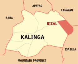 Map of Kalinga with Rizal highlighted | |

| |
.svg.png) Rizal Location within the Philippines | |
| Coordinates: 17°30′N 121°36′E | |
| Country | |
| Region | Cordillera Administrative Region (CAR) |
| Province | Kalinga |
| District | Lone District |
| Barangays | 14 (see Barangays) |
| Government | |
| • Type | Sangguniang Bayan |
| • Mayor | Karl Bugao P. Baac |
| • Vice Mayor | Samuel C. Valdez |
| • Congressman | Allen Jesse C. Mangaoang |
| • Electorate | 12,560 voters (2019) |
| Area | |
| • Total | 231.00 km2 (89.19 sq mi) |
| Elevation | 92.8 m (304.5 ft) |
| Population (2015 census)[3] | |
| • Total | 17,038 |
| • Density | 74/km2 (190/sq mi) |
| • Households | 3,718 |
| Economy | |
| • Income class | 4th municipal income class |
| • Poverty incidence | 15.32% (2015)[4] |
| • Revenue (₱) | 78,763,016.02 (2016) |
| Time zone | UTC+8 (PST) |
| ZIP code | 3808 |
| PSGC | |
| IDD : area code | +63 (0)74 |
| Climate type | tropical rainforest climate |
| Native languages | Kalinga language Ilocano Tagalog |
| Website | www |
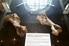
The town is famous for its Pleistocene sites which possesses rhino bones, tools, deer bones, turtle remains, and stegodon bones. The butchered rhino bones were confirmed by international scientific journals as proof of ancient hominids in the Philippines dating back to 709,000 years ago, the oldest hominid evidence in the entire Philippine archipelago. The discovery was confirmed in 2018, and has been a game-changer in Philippine prehistory.[5]
Barangays
Climate
| Climate data for Rizal, Kalinga | |||||||||||||
|---|---|---|---|---|---|---|---|---|---|---|---|---|---|
| Month | Jan | Feb | Mar | Apr | May | Jun | Jul | Aug | Sep | Oct | Nov | Dec | Year |
| Average high °C (°F) | 26 (79) |
27 (81) |
29 (84) |
32 (90) |
32 (90) |
31 (88) |
31 (88) |
30 (86) |
30 (86) |
29 (84) |
27 (81) |
26 (79) |
29 (85) |
| Average low °C (°F) | 21 (70) |
21 (70) |
22 (72) |
23 (73) |
24 (75) |
25 (77) |
24 (75) |
25 (77) |
24 (75) |
23 (73) |
23 (73) |
21 (70) |
23 (73) |
| Average precipitation mm (inches) | 109 (4.3) |
78 (3.1) |
64 (2.5) |
54 (2.1) |
181 (7.1) |
196 (7.7) |
204 (8.0) |
211 (8.3) |
174 (6.9) |
198 (7.8) |
185 (7.3) |
231 (9.1) |
1,885 (74.2) |
| Average rainy days | 17.2 | 13.7 | 13.2 | 13.0 | 21.7 | 23.4 | 25.2 | 25.2 | 21.9 | 17.7 | 18.6 | 20.8 | 231.6 |
| Source: Meteoblue [6] | |||||||||||||
Demographics
| Population census of Rizal | ||
|---|---|---|
| Year | Pop. | ±% p.a. |
| 1970 | 8,034 | — |
| 1975 | 11,715 | +7.86% |
| 1980 | 11,637 | −0.13% |
| 1990 | 10,885 | −0.67% |
| 1995 | 12,173 | +2.12% |
| 2000 | 13,652 | +2.49% |
| 2007 | 14,614 | +0.94% |
| 2010 | 15,942 | +3.22% |
| 2015 | 17,038 | +1.27% |
| Source: Philippine Statistics Authority[3][7][8][9] | ||
In the 2015 census, the population of Rizal, Kalinga, was 17,038 people,[3] with a density of 74 inhabitants per square kilometre or 190 inhabitants per square mile.
See also
- List of renamed cities and municipalities in the Philippines
References
- "Municipality". Quezon City, Philippines: Department of the Interior and Local Government. Retrieved 31 May 2013.
- "Province: Kalinga". PSGC Interactive. Quezon City, Philippines: Philippine Statistics Authority. Retrieved 12 November 2016.
- Census of Population (2015). "Cordillera Administrative Region (CAR)". Total Population by Province, City, Municipality and Barangay. PSA. Retrieved 20 June 2016.
- "PSA releases the 2015 Municipal and City Level Poverty Estimates". Quezon City, Philippines. Retrieved 12 October 2019.
- Inquirer, Philippine Daily (May 4, 2018). "Earliest humans arrived in PH 700,000 years ago" (Vol. 33, No. 145). France's National Museum of History. Retrieved 4 May 2018.
- "Rizal: Average Temperatures and Rainfall". Meteoblue. Retrieved 8 March 2020.
- Census of Population and Housing (2010). "Cordillera Administrative Region (CAR)". Total Population by Province, City, Municipality and Barangay. NSO. Retrieved 29 June 2016.
- Censuses of Population (1903–2007). "Cordillera Administrative Region (CAR)". Table 1. Population Enumerated in Various Censuses by Province/Highly Urbanized City: 1903 to 2007. NSO.
- "Province of Kalinga". Municipality Population Data. Local Water Utilities Administration Research Division. Retrieved 17 December 2016.
External links
- Rizal Profile at PhilAtlas.com
- Philippine Standard Geographic Code
- Philippine Census Information
- Local Governance Performance Management System
Places adjacent to Rizal, Kalinga | |
|---|---|
Tabuk (capital) | |
| Municipalities | |
| Component city | |
| Barangays | |