Tublay, Benguet
Tublay, officially the Municipality of Tublay, (Ilocano: Ili ti Tublay; Tagalog: Bayan ng Tublay), is a 5th class municipality in the province of Benguet, Philippines. According to the 2015 census, it has a population of 17,892 people.[4]
Tublay | |
|---|---|
| Municipality of Tublay | |
 Seal | |
 Map of Benguet with Tublay highlighted | |
OpenStreetMap 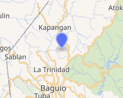
| |
.svg.png) Tublay Location within the Philippines | |
| Coordinates: 16°31′N 120°37′E | |
| Country | |
| Region | Cordillera Administrative Region (CAR) |
| Province | Benguet |
| District | Lone District |
| Barangays | 8 (see Barangays) |
| Government | |
| • Type | Sangguniang Bayan |
| • Mayor | Armando I. Lauro |
| • Vice Mayor | Juan L. Esnara |
| • Congressman | Nestor B. Fongwan |
| • Electorate | 10,727 voters (2019) |
| Area | |
| • Total | 102.55 km2 (39.59 sq mi) |
| Elevation | 1,403.0 m (4,603.0 ft) |
| Population (2015 census)[4] | |
| • Total | 17,892 |
| • Density | 170/km2 (450/sq mi) |
| • Households | 3,854 |
| Economy | |
| • Income class | 5th municipal income class |
| • Poverty incidence | 9.65% (2015)[5] |
| • Revenue (₱) | 64,875,849.82 (2016) |
| Time zone | UTC+8 (PST) |
| ZIP code | 2615 |
| PSGC | |
| IDD : area code | +63 (0)74 |
| Climate type | tropical rainforest climate |
| Native languages | Kankanaey language Ibaloi Ilocano Tagalog |
| Website | www |
History
Tublay began as a township organized by the American government in November 1900. Magastino Laruan is appointed as the first town president (mayor) of Tublay. He is a part of the Cariño Family in Benguet.
Geography
Tublay is at the central portion of Benguet. It is bounded by Kapangan on the north, Atok on the east, Itogon and Bokod on the southeast, La Trinidad on the west, and Sablan on the northwest.
According to the Philippine Statistics Authority, the municipality has a land area of 102.55 square kilometres (39.59 sq mi) [2] constituting 3.70% of the 2,769.08-square-kilometre- (1,069.15 sq mi) total area of Benguet.
The topography is generally mountainous with an elevation of 1,400 metres (4,600 ft) above sea level. It has two pronounced seasons - the dry and the wet seasons with a temperature coldest at 6.5 °C (43.7 °F) and warmest at 27.5 °C (81.5 °F). There are 2 seasons for Tublay, Benguet will be wet season from May to October and dry season from November to April.
The municipality is located 263 kilometres (163 mi) north of Manila and 13 kilometres (8.1 mi) north of Baguio.
Barangays
Tublay is politically subdivided into 8 barangays.[6] Ambassador is the largest barangay in terms of land area (11.52 km²), while Tuel is the smallest (4.79 km²).
| PSGC | Barangay | Population | ±% p.a. | |||
|---|---|---|---|---|---|---|
| 2015[4] | 2010[7] | |||||
| 141114001 | Ambassador | 28.8% | 5,160 | 4,799 | 1.39% | |
| 141114002 | Ambongdolan | 5.4% | 968 | 980 | −0.23% | |
| 141114003 | Ba‑ayan | 10.0% | 1,784 | 1,736 | 0.52% | |
| 141114004 | Basil | 7.1% | 1,278 | 1,198 | 1.24% | |
| 141114005 | Daclan | 13.3% | 2,378 | 1,937 | 3.98% | |
| 141114006 | Caponga (Poblacion) | 24.0% | 4,295 | 4,049 | 1.13% | |
| 141114007 | Tublay Central | 4.8% | 858 | 896 | −0.82% | |
| 141114008 | Tuel | 6.5% | 1,171 | 960 | 3.86% | |
| Total | 17,892 | 16,555 | 1.49% | |||
Climate
| Climate data for Tublay, Benguet | |||||||||||||
|---|---|---|---|---|---|---|---|---|---|---|---|---|---|
| Month | Jan | Feb | Mar | Apr | May | Jun | Jul | Aug | Sep | Oct | Nov | Dec | Year |
| Average high °C (°F) | 24 (75) |
25 (77) |
26 (79) |
27 (81) |
26 (79) |
25 (77) |
24 (75) |
24 (75) |
24 (75) |
25 (77) |
25 (77) |
25 (77) |
25 (77) |
| Average low °C (°F) | 15 (59) |
16 (61) |
17 (63) |
19 (66) |
10 (50) |
10 (50) |
19 (66) |
19 (66) |
19 (66) |
18 (64) |
17 (63) |
16 (61) |
16 (61) |
| Average precipitation mm (inches) | 42 (1.7) |
48 (1.9) |
74 (2.9) |
110 (4.3) |
269 (10.6) |
275 (10.8) |
362 (14.3) |
325 (12.8) |
330 (13.0) |
306 (12.0) |
126 (5.0) |
61 (2.4) |
2,328 (91.7) |
| Average rainy days | 11.2 | 12.0 | 17.1 | 21.2 | 27.1 | 26.8 | 28.1 | 27.0 | 26.0 | 24.5 | 17.7 | 12.4 | 251.1 |
| Source: Meteoblue [8] | |||||||||||||
Demographics
| Population census of Tublay | |||||||||||||||||||||||||||||||||||||||||||||||||
|---|---|---|---|---|---|---|---|---|---|---|---|---|---|---|---|---|---|---|---|---|---|---|---|---|---|---|---|---|---|---|---|---|---|---|---|---|---|---|---|---|---|---|---|---|---|---|---|---|---|
|
| ||||||||||||||||||||||||||||||||||||||||||||||||
| Source: Philippine Statistics Authority[4][7][9][10] | |||||||||||||||||||||||||||||||||||||||||||||||||
In the 2015 census, Tublay had a population of 17,892.[4] The population density was 170 inhabitants per square kilometre (440/sq mi).
Education
Public schools
As of 2014, Tublay has 19 public elementary schools and 2 public secondary schools.[11][12][13]
|
|
References
- "Municipality". Quezon City, Philippines: Department of the Interior and Local Government. Retrieved 31 May 2013.
- "Province: Benguet". PSGC Interactive. Quezon City, Philippines: Philippine Statistics Authority. Retrieved 12 November 2016.
- "Tublay, Benguet Profile". PhilAtlas.com. Retrieved 15 June 2020.
- Census of Population (2015). "Cordillera Administrative Region (CAR)". Total Population by Province, City, Municipality and Barangay. PSA. Retrieved 20 June 2016.
- "PSA releases the 2015 Municipal and City Level Poverty Estimates". Quezon City, Philippines. Retrieved 12 October 2019.
- "Municipal: Tublay, Benguet". PSGC Interactive. Quezon City, Philippines: Philippine Statistics Authority. Retrieved 8 January 2016.
- Census of Population and Housing (2010). "Cordillera Administrative Region (CAR)". Total Population by Province, City, Municipality and Barangay. NSO. Retrieved 29 June 2016.
- "Tublay: Average Temperatures and Rainfall". Meteoblue. Retrieved 21 March 2020.
- Censuses of Population (1903–2007). "Cordillera Administrative Region (CAR)". Table 1. Population Enumerated in Various Censuses by Province/Highly Urbanized City: 1903 to 2007. NSO.
- "Province of Benguet". Municipality Population Data. Local Water Utilities Administration Research Division. Retrieved 17 December 2016.
- "Masterlist of Public Elementary Schools for the School year 2012- 2013" (XLSX). Department of Education (Philippines), July 15, 2013. Retrieved 28 December 2014.
- "Masterlist of Secondary Schools (School Year 2013- 2014)". Department of Education (Philippines), July 4, 2013. Archived from the original (XLSX) on 1 July 2014. Retrieved 20 November 2014.
- "Masterlist of Public Schools SY 2013-2014" (XLSX). Department of Education (Philippines), 22 October 2014. Retrieved 28 December 2014.
External links
Places adjacent to Tublay, Benguet | ||||||||||
|---|---|---|---|---|---|---|---|---|---|---|
| ||||||||||
|
La Trinidad (capital) | |
| Municipalities | |
| Highly urbanized city |
|
| Barangays | |