Kiangan, Ifugao
Kiangan, officially the Municipality of Kiangan is a 4th class municipality in the province of Ifugao, Philippines. According to the 2015 census, it has a population of 17,048 people.[3]
Kiangan | |
|---|---|
| Municipality of Kiangan | |
 Nagacadan Rice Terraces | |
 Map of Ifugao with Kiangan highlighted | |

| |
.svg.png) Kiangan Location within the Philippines | |
| Coordinates: 16°47′N 121°05′E | |
| Country | |
| Region | Cordillera Administrative Region (CAR) |
| Province | Ifugao |
| District | Lone District |
| Barangays | 14 (see Barangays) |
| Government | |
| • Type | Sangguniang Bayan |
| • Mayor | Raldis Andrei A. Bulayungan |
| • Vice Mayor | Michelle Alice B. Baguilat |
| • Congressman | Solomon R. Chungalao |
| • Electorate | 11,671 voters (2019) |
| Area | |
| • Total | 200.00 km2 (77.22 sq mi) |
| Elevation | 772.2 m (2,533.5 ft) |
| Population (2015 census)[3] | |
| • Total | 17,048 |
| • Density | 85/km2 (220/sq mi) |
| • Households | 3,479 |
| Economy | |
| • Income class | 4th municipal income class |
| • Poverty incidence | 24.2% (2015)[4] |
| • Revenue (₱) | 75,117,494.00 (2016) |
| Time zone | UTC+8 (PST) |
| ZIP code | 3604 |
| PSGC | |
| IDD : area code | +63 (0)74 |
| Climate type | tropical rainforest climate |
| Native languages | Ifugao language Kallahan language Tuwali language Ilocano Tagalog |
| Website | kiangan |
Kiangan is the oldest town in the province. It derives its name from Kiyyangan, an ancient village near the bank of the Ibulao River across the Lagawe valley. The name Kiyyangan is enshrined in Ifugao mythology and is believed to be the dwelling of Wigan and Bugan, the mythological ancestors of the Ifugao. It was the former capital of Ifugao until the topology was deemed unfit and moved to neighboring Lagawe.
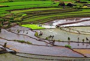
The Nagacadan Rice Terraces are part of the Rice Terraces of the Philippine Cordilleras World Heritage Site.
Barangays
Kiangan is politically subdivided into 14 barangays. [2]
- Ambabag
- Baguinge
- Bolog
- Bokiawan
- Dalligan
- Duit
- Hucab
- Julongan
- Lingay
- Mungayang
- Nagacadan
- Pindongan
- Poblacion
- Tuplac
Climate
| Climate data for Kiangan, Ifugao | |||||||||||||
|---|---|---|---|---|---|---|---|---|---|---|---|---|---|
| Month | Jan | Feb | Mar | Apr | May | Jun | Jul | Aug | Sep | Oct | Nov | Dec | Year |
| Average high °C (°F) | 21 (70) |
22 (72) |
24 (75) |
25 (77) |
25 (77) |
25 (77) |
24 (75) |
24 (75) |
24 (75) |
24 (75) |
23 (73) |
21 (70) |
24 (74) |
| Average low °C (°F) | 14 (57) |
15 (59) |
16 (61) |
18 (64) |
19 (66) |
19 (66) |
19 (66) |
19 (66) |
19 (66) |
17 (63) |
16 (61) |
15 (59) |
17 (63) |
| Average precipitation mm (inches) | 35 (1.4) |
46 (1.8) |
63 (2.5) |
117 (4.6) |
402 (15.8) |
400 (15.7) |
441 (17.4) |
471 (18.5) |
440 (17.3) |
258 (10.2) |
94 (3.7) |
68 (2.7) |
2,835 (111.6) |
| Average rainy days | 9.9 | 11.1 | 13.9 | 18.9 | 26.0 | 27.3 | 28.9 | 28.5 | 26.1 | 19.7 | 14.5 | 12.8 | 237.6 |
| Source: Meteoblue [5] | |||||||||||||
Demographics
| Population census of Kiangan | ||
|---|---|---|
| Year | Pop. | ±% p.a. |
| 1918 | 37,161 | — |
| 1939 | 16,146 | −3.89% |
| 1948 | 10,534 | −4.63% |
| 1960 | 12,689 | +1.56% |
| 1970 | 15,123 | +1.77% |
| 1975 | 15,935 | +1.05% |
| 1980 | 17,481 | +1.87% |
| 1990 | 21,329 | +2.01% |
| 1995 | 13,514 | −8.20% |
| 2000 | 14,099 | +0.91% |
| 2007 | 15,448 | +1.27% |
| 2010 | 15,837 | +0.91% |
| 2015 | 17,048 | +1.41% |
| Source: Philippine Statistics Authority[3][6][7][8] | ||
In the 2015 census, the population of Kiangan, Ifugao, was 17,048 people,[3] with a density of 85 inhabitants per square kilometre or 220 inhabitants per square mile.
Locally spoken languages include Tuwali, Ayangan, Ilocano, Tagalog, and English.
Economy
Agriculture and tourism are the main sources of local economic activities which supports commerce and trade among townsfolk. Its terraced rice fields do not only provide produce for the farmers but attract tourists as well.
Culture
_(2141831843).jpg)

- Nagacadan Rice Terraces
The Nagacadan Rice Terraces is a UNESCO Heritage Site and one of the many rice terraces in the province of Ifugao. The rice terraces cluster manifest a distinct feature - the fields are in ascending rows of terraces bisected by a river.
- Kiangan Shrine
Located in Kiangan is the Kiangan Central School old home economics building, which marks the spot where the highest Commander of the Japanese Imperial Army, General Tomoyuki Yamashita (also known as the Tiger of Malaya), surrendered to the Filipino & American Forces on 2 September 1945.


References
- "Municipality". Quezon City, Philippines: Department of the Interior and Local Government. Retrieved 31 May 2013.
- "Province: Ifugao". PSGC Interactive. Quezon City, Philippines: Philippine Statistics Authority. Retrieved 12 November 2016.
- Census of Population (2015). "Cordillera Administrative Region (CAR)". Total Population by Province, City, Municipality and Barangay. PSA. Retrieved 20 June 2016.
- "PSA releases the 2015 Municipal and City Level Poverty Estimates". Quezon City, Philippines. Retrieved 12 October 2019.
- "Kiangan: Average Temperatures and Rainfall". Meteoblue. Retrieved 8 March 2020.
- Census of Population and Housing (2010). "Cordillera Administrative Region (CAR)". Total Population by Province, City, Municipality and Barangay. NSO. Retrieved 29 June 2016.
- Censuses of Population (1903–2007). "Cordillera Administrative Region (CAR)". Table 1. Population Enumerated in Various Censuses by Province/Highly Urbanized City: 1903 to 2007. NSO.
- "Province of Ifugao". Municipality Population Data. Local Water Utilities Administration Research Division. Retrieved 17 December 2016.
External links
| Wikimedia Commons has media related to Kiangan, Ifugao. |