Alamcode, Thiruvananthapuram
Alamcode is a census town in Varkala Taluk of Thiruvananthapuram district in the state of Kerala, India. Alamcode is a area of Attingal Municipality and also a suburb town in Trivandrum metropolitan area. The nearest Airport is Trivandrum International Airport (33 km) and Kadakkavur Railway Station (6.3 km) is the nearest Railway Station. [1]
Alamcode | |
|---|---|
Northern suburb of Trivandrum city | |
 Alamcode Location in Kerala, India  Alamcode Alamcode (India) | |
| Coordinates: 8.503°N 76.952°E | |
| Country | |
| State | Kerala |
| District | Thiruvananthapuram district |
| Talukas | Varkala Taluk Chirayinkeezh |
| Population (2001) | |
| • Total | 12,954 |
| Languages | |
| • Official | Malayalam, English |
| Time zone | UTC+5:30 (IST) |
| PIN | 695102 |
| Vehicle registration | KL-16 |
Demographics
As of 2001 India census, Alamcode had a population of 12954 with 6231 males and 6723 females.[1] Alamcode is a part of Attingal City.
References
- "Census of India : Villages with population 5000 & above". Registrar General & Census Commissioner, India. Archived from the original on 8 December 2008. Retrieved 10 December 2008.
District HQ: Thiruvananthapuram | |||||||
| History | 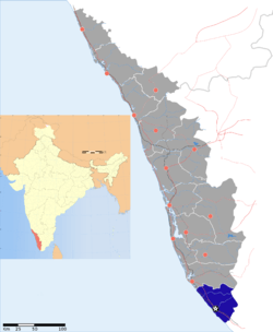 | ||||||
| Geography | |||||||
| Cities and Taluks |
| ||||||
| Transport | |||||||
| Education |
| ||||||
| Buildings | |||||||
| Culture | |||||||
| Lok Sabha constituencies | |||||||
| Sports |
| ||||||
| Museums | |||||||
District HQ: Thiruvananthapuram | |
| Chirayinkeezhu |
|
| Nedumangad | |
| Neyyattinkara |
|
| Thiruvananthapuram | |
This article is issued from Wikipedia. The text is licensed under Creative Commons - Attribution - Sharealike. Additional terms may apply for the media files.