Webster, Texas
Webster is a city in the U.S. state of Texas located in Harris County, within the Houston–Sugar Land–Baytown metropolitan area. The population was 10,400 at the 2010 census.[3]
Webster, Texas | |
|---|---|
 Webster City Hall and Police Department | |
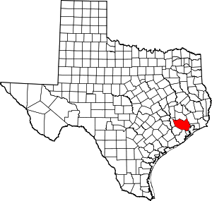
 Location in Harris County and the state of Texas | |
| Coordinates: 29°32′19″N 95°7′10″W | |
| Country | United States |
| State | Texas |
| County | Harris |
| Area | |
| • Total | 6.6 sq mi (17.0 km2) |
| • Land | 6.3 sq mi (16.4 km2) |
| • Water | 0.2 sq mi (0.6 km2) |
| Elevation | 26 ft (8 m) |
| Population (2010) | |
| • Total | 10,400 |
| • Density | 1,686/sq mi (651.0/km2) |
| Time zone | UTC-6 (Central (CST)) |
| • Summer (DST) | UTC-5 (CDT) |
| ZIP code | 77598 |
| Area code(s) | 281 |
| FIPS code | 48-76948[1] |
| GNIS feature ID | 1349594[2] |
| Website | www |
History

The community was founded in 1879 by James W. Webster under the name "Gardentown". It was established initially as a colony for settlers from England. It began as a stopover for travelers between Houston/Harrisburg, Galveston, Kemah, and Seabrook. Eventually railroads, such as the Missouri, Kansas and Texas Railway, were built through the area. Farmers in the area raised pears and other produce.[4]
In 1903, the Houston Chamber of Commerce invited Seito Saibara, a former Japanese member of parliament and a Christian theologian, to come to Texas to teach rice farming. Rice at that time was emerging as an important cash crop. Saibara settled in Webster and established a small farming community of Japanese Christians. Saibara and his son Kiyoaki established the foundations of what became the rice industry of the U.S. Gulf Coast.[5][6]
Dairies and livestock ranches developed in the town as well in the early 1900s. Petroleum was discovered at the Webster-Friendswood Oilfield in the 1930s, but the population remained small. The community was incorporated in 1958.[4]
In 1961 the National Aeronautics and Space Administration announced that it was building the Manned Spacecraft Center (now known as the Johnson Space Center) nearby along the shores of Clear Lake. Growth and development quickly swept over the Clear Lake Area, and Webster's population blossomed.[4] Webster today has become a thriving bedroom community closely tied to the Clear Lake Area and its high-tech industry.
Geography
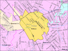
Webster is located in southeastern Harris County at 29°32′19″N 95°07′10″W (29.538581, -95.119354).[7] It is bordered to the north by the city of Houston and to the northeast by Nassau Bay. Clear Creek forms the southeastern border of Webster and is the Harris County / Galveston County line. League City borders Webster to the south and southwest, in both counties.
Interstate 45 runs through the western side of Webster, with access from Exits 23 through 25. Downtown Houston is 22 miles (35 km) to the northwest, and Galveston is 28 miles (45 km) to the southeast.
According to the United States Census Bureau, the city has a total area of 6.6 square miles (17.0 km2), of which 6.3 square miles (16.4 km2) are land and 0.23 square miles (0.6 km2), or 3.24%, are water.[3]
Climate
The climate in this area is characterized by hot, humid summers and generally mild to cool winters. According to the Köppen Climate Classification system, Webster has a humid subtropical climate, abbreviated "Cfa" on climate maps.[8]
Demographics
| Historical population | |||
|---|---|---|---|
| Census | Pop. | %± | |
| 1960 | 329 | — | |
| 1970 | 2,231 | 578.1% | |
| 1980 | 2,405 | 7.8% | |
| 1990 | 4,678 | 94.5% | |
| 2000 | 9,083 | 94.2% | |
| 2010 | 10,684 | 17.6% | |
| Est. 2019 | 11,451 | [9] | 7.2% |
| U.S. Decennial Census[10] | |||
As of the census[1] of 2000, there were 9,083 people, 4,114 households, and 1,970 families residing in the city. The population density was 1,372.9 people per square mile (529.8/km2). There were 4,733 housing units at an average density of 715.4 per square mile (276.0/km2). The racial makeup of the city was 64.85% White, 9.03% African American, 0.55% Native American, 5.72% Asian, 0.15% Pacific Islander, 15.78% from other races, and 3.92% from two or more races. Hispanic or Latino of any race were 27.24% of the population.
There were 4,114 households out of which 24.6% had children under the age of 18 living with them, 32.7% were married couples living together, 10.1% had a female householder with no husband present, and 52.1% were non-families. 40.6% of all households were made up of individuals and 2.1% had someone living alone who was 65 years of age or older. The average household size was 2.14 and the average family size was 2.97.
In the city, the population was spread out with 20.9% under the age of 18, 15.0% from 18 to 24, 43.5% from 25 to 44, 15.4% from 45 to 64, and 5.1% who were 65 years of age or older. The median age was 29 years. For every 100 females, there were 109.3 males. For every 100 females age 18 and over, there were 107.3 males.
The median income for a household in the city was $42,385, and the median income for a family was $43,495. Males had a median income of $35,346 versus $29,808 for females. The per capita income for the city was $21,964. About 12.5% of families and 13.2% of the population were below the poverty line, including 19.2% of those under age 18 and 5.6% of those age 65 or over.
Government and infrastructure

The city of Webster has two fire stations, Station #1 and Station #2, with the fire department offices in the second station.[11] The city has its own police department.[12]
Harris County Housing Authority (HCHA) operates Baybrook Park, a public housing complex for seniors, in the Webster city limits. It has 100 units.[13]
The Texas Department of Public Safety (DPS) operates its Webster Field Investigator Office and its Webster Driver's License Office in a nearby area in Houston.[14][15]
The Texas Department of Criminal Justice (TDCJ) operates the Webster District Parole Office in a nearby area in Houston.[16]
The United States Postal Service Webster Post Office is located at 17077 North Texas Avenue.[17] Some locations in the City of Houston have Webster mailing addresses.[18]
Economy
The Baybrook Mall is located in the City of Houston.[19] The mall is in proximity to Webster.[20]
Education

Primary and secondary schools
Public schools
Pupils in Webster attend schools in Clear Creek Independent School District.[21] The community is divided between the Board of Trustees District 2 and the Board of Trustees District 4.[22][23] They are represented by Win Weber and Stuart J. Stromeyer, respectively, as of 2008.[24]
Most residents within the city limits are zoned to Margaret S. McWhirter Elementary School in Webster.[25] The school occupies a 125,000-square-foot (11,600 m2) building that is one story tall. The current McWhirter campus held its groundbreaking in 2014,[26] and opened in 2016.[27] The re-dedication was held in March of that year.[28] That year the Texas Education Agency (TEA) gave the school a grant allowing it to re-establish a full day PreKindergarten program.[29]
Some residential sections of the city are served by Armand Bayou (Houston),[30] Falcon Pass (Houston),[31] League City (League City),[32] and Whitcomb (Houston) elementary schools.[33] Most residents are zoned to Clear Creek Intermediate School (League City).[34] Some residents are zoned to Clear Lake,[35] and Space Center intermediate schools, both in Clear Lake City and in Houston.[36] Most residents are zoned to Clear Creek High School in League City,[37] while Clear Lake High School in Clear Lake City, Houston, serves a small section.[38]
P.H. Greene Elementary School, in an unincorporated area, serves areas outside of the city with Webster addresses.[39]
History of schools
Webster Intermediate School formerly served the city but moved to an unincorporated area near Friendswood and was renamed Westbrook Intermediate School in spring 2005;[40] As of 2016 Westbrook does not serve Webster.
Private schools
Iman Academy Southeast Secondary School is in southeast Houston, northeast of Webster, off of Highway 3.[19][41]
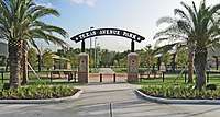
Parks and recreation
The Edgar A. Smith Family YMCA is located in Houston; it has a Webster mailing address.
Notable people
- Stephanie Beatriz, actress
- Josh Huestis, basketball player for the Oklahoma City Thunder
- Dennis Paul, Republican member of the Texas House of Representatives from District 129, formerly resided in Webster
- Steve Stockman, Republican former member of the United States House of Representatives from Texas's 36th congressional district
- Ryan Trecartin, multimedia artist
See also
References
- "U.S. Census website". United States Census Bureau. Retrieved 2008-01-31.
- "US Board on Geographic Names". United States Geological Survey. 2007-10-25. Retrieved 2008-01-31.
- "Geographic Identifiers: 2010 Census Summary File 1 (G001): Webster city, Texas (Revision of 11-23-2012)". American Factfinder. U.S. Census Bureau. Archived from the original on February 13, 2020. Retrieved February 6, 2018.
- Kleiner, Diana J.: Webster, Texas from the Handbook of Texas Online. Retrieved 26 January 2010. Texas State Historical Association.
- "History of Webster, Texas". City of Webster. Retrieved 26 January 2010.
- Saibara, Seito from the Handbook of Texas Online. Retrieved 26 January 2010. Texas State Historical Association.
- "US Gazetteer files: 2010, 2000, and 1990". United States Census Bureau. 2011-02-12. Retrieved 2011-04-23.
- "Webster, Texas Köppen Climate Classification (Weatherbase)".
- "Population and Housing Unit Estimates". Retrieved May 21, 2020.
- "Census of Population and Housing". Census.gov. Retrieved June 4, 2015.
- "Public Information Phone Numbers." City of Webster. Retrieved on May 16, 2010.
- "Our Properties." Harris County Housing Authority. Retrieved on January 1, 2019. "Baybrook Park Address: 500 W. Texas Avenue, Webster, TX 77598"
- "Field Investigator Offices." Texas Department of Public Safety. Retrieved on May 16, 2010.
- "Texas Driver License Office Map." Texas Department of Public Safety. Retrieved on May 16, 2010.
- "Parole Division Region III Archived 2010-07-25 at the Wayback Machine." Texas Department of Criminal Justice. Retrieved on May 15, 2010.
- "WEBSTER." United States Postal Service. Retrieved on April 24, 2018. "17077 N TEXAS AVE WEBSTER, TX 77598-9998"
- "City of Houston Annexation FAQ". City of Houston. 1996-10-31. Archived from the original on 1996-10-31. Retrieved 2018-04-24.
Numerous residents of the City of Houston have Missouri City, Webster, Friendswood, Stafford, Humble and even Kingwood addresses.
- "SN_81.pdf" (Archive). Retrieved on March 31, 2014.
- Kaplan, David. "Major expansion set for Baybrook Mall." Houston Chronicle. March 24, 2014. Retrieved on March 31, 2014. "The company that owns the indoor shopping complex off the Gulf Freeway in suburban Webster will add 555,000 square feet of retail, restaurant and entertainment space and create a community lawn the length of a football field."
- Zoning Map. City of Webster. Retrieved on December 31, 2016.
- District 2 Map. Clear Creek Independent School District. Retrieved on December 6, 2008.
- District 4 Map. Clear Creek Independent School District. Retrieved on December 6, 2008.
- "School Board Members: Bios and Contact Information." Clear Creek Independent School District. Retrieved on December 6, 2008.
- McWhirter Elementary zone map. Clear Creek Independent School District. Retrieved on December 31, 2016.
- "Clear Creek ISD breaks ground on McWhirter Elementary". Bay Area Citizen at the Houston Chronicle. 2014-06-09. Retrieved 2016-12-31.
- "New McWhirter Elementary School Opens in Webster Rededication Ceremony Set for March 3". Clear Creek Independent School District. 2016-02-08. Retrieved 2016-12-31.
- "New look McWhirter Elementary opens its doors". Bay Area Citizen at the Houston Chronicle. 2016-03-04. Retrieved 2016-12-31.
- Hill, Glynn A. (2016-06-28). "McWhirter revives full-day pre-K program". The Bay Area Citizen. Retrieved 2016-12-31.
- Armand Bayou Elementary zone map. Clear Creek Independent School District. Retrieved on December 31, 2016. See the bottom part of the map, which indicates an exclave of Armand Bayou's attendance boundary.
- "Falcon Pass Elementary zone map. Clear Creek Independent School District. Retrieved on December 31, 2016.
- League City Elementary zone map." Clear Creek Independent School District. Retrieved on December 31, 2016.
- "Whitcomb Elementary zone map. Clear Creek Independent School District. Retrieved on December 31, 2016.
- Clear Creek Intermediate zone. Clear Creek Independent School District. Retrieved on December 31, 2016.
- Clear Lake Intermediate zone. Clear Creek Independent School District. Retrieved on December 31, 2016.
- Space Center Intermediate zone. Clear Creek Independent School District. Retrieved on December 31, 2016.
- Clear Creek High zone. Clear Creek Independent School District. Retrieved on December 31, 2016.
- Clear Lake High zone. Clear Creek Independent School District. Retrieved on December 31, 2016.
- "P.H. Greene zone map. Clear Creek Independent School District. Retrieved on December 31, 2016.
- Hunter, Rachel. "Changes to attendance zones approved." Galveston County Daily News. February 26, 2005. Retrieved on March 31, 2014. "The district is closing Webster Intermediate at the end of the school year and a replacement campus, Westbrook Intermediate, is scheduled to open in August, Taylor said. Although Westbrook is a new campus, she said, it is simply replacing Webster, which will become an alternative school for students at risk of failing or dropping out. Taylor said the replacement campus would not provide the district with additional space for intermediate school students, but attendance zones needed to be changed to include the new campus."
- "Contact Us." Iman Academy. Retrieved on November 14, 2010. "825 Jetstream Ct, Webster TX 77598"
External links
| Wikimedia Commons has media related to Webster, Texas. |
- City of Webster official website
- Handbook of Texas Online article on Webster
- McWhirter Elementary School
| Large cities |  | |
|---|---|---|
| Other cities | ||
| CDPs and non- municipalities | ||
| Counties | ||
| Subregions | ||
| Bodies of water | ||
| Major ports | ||
| Nature preserves | ||
| Counties |  | |
|---|---|---|
| "Principal" cities | ||
| Other cities |
For a complete listing, see list of cities and towns in Houston–The Woodlands–Sugar Land MSA | |
| Unincorporated areas | ||
| Bodies of water | ||

| Authority control |
|---|