Adams Township, Hamilton County, Indiana
| Adams Township | |
|---|---|
| Township | |
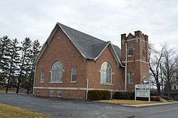 Wesleyan church at Bakers Corner | |
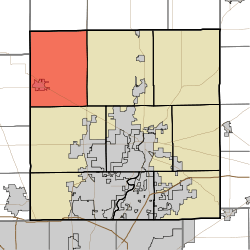 Location in Hamilton County | |
| Coordinates: 40°09′25″N 86°11′08″W / 40.15694°N 86.18556°WCoordinates: 40°09′25″N 86°11′08″W / 40.15694°N 86.18556°W | |
| Country | United States |
| State | Indiana |
| County | Hamilton |
| Government | |
| • Type | Indiana township |
| Area | |
| • Total | 48.36 sq mi (125.3 km2) |
| • Land | 48.27 sq mi (125.0 km2) |
| • Water | 0.09 sq mi (0.2 km2) 0.19% |
| Elevation | 922 ft (281 m) |
| Population (2010) | |
| • Total | 4,858 |
| • Density | 100.6/sq mi (38.8/km2) |
| GNIS feature ID | 0453077 |
Adams Township is one of nine townships in Hamilton County, Indiana, United States. At the 2010 census, its population was 4,858 and it contained 2,056 housing units.[1]
History
Adams Township was organized in 1833.[2]
Geography
According to the 2010 census, the township has a total area of 48.36 square miles (125.3 km2), of which 48.27 square miles (125.0 km2) (or 99.81%) is land and 0.09 square miles (0.23 km2) (or 0.19%) is water.[1] The streams of Baker Ditch, Cicero Creek, Eagle Creek, Fouch Ditch, Hinkle Creek, Jay Ditch, Jones Ditch, Lindley Ditch, Little Cicero Creek, McKinzie Ditch, Pearce Ditch, Prairie Creek, Ross Ditch and Teter Branch, run through the township.
Cities and towns
Unincorporated towns
(This list is based on USGS data and may include former settlements.)
Adjacent townships
- Jefferson Township, Tipton County (north)
- Cicero Township, Tipton County (northeast)
- Jackson Township (east)
- Washington Township (south)
- Marion Township, Boone County (west)
- Sugar Creek Township, Clinton County (northwest)
Cemeteries
The township contains nine cemeteries: Boxley, Crown Hill, Phillips, Ridge, Spencer, Spicewood, Teter, Union Grove and Wiles.
Major highways
Airports and landing strips
- Black Hawk Airport
- Sheridan Airport
- Windy Knoll Airport
Education
Adams Township residents may obtain a free library card from Sheridan Public Library in Sheridan.[3]
References
- "Adams Township, Hamilton County, Indiana". Geographic Names Information System. United States Geological Survey. Retrieved 14 September 2009.
- United States Census Bureau cartographic boundary files
- 1 2 "Population, Housing Units, Area, and Density: 2010 - County -- County Subdivision and Place -- 2010 Census Summary File 1". United States Census. Retrieved 10 May 2013.
- ↑ Haines, John F. (1915). History of Hamilton County, Indiana: Her People, Industries And Institutions, Volume 1. B.F. Bowen & Co. p. 146.
- ↑ "Get a library card". Sheridan Public Library. Retrieved 7 March 2018.
External links
Municipalities and communities of Hamilton County, Indiana, United States | ||
|---|---|---|
| Cities | ||
| Towns | ||
| Townships | ||
| Unincorporated communities | ||
| Footnotes | ‡This populated place also has portions in an adjacent county or counties | |