Elwood, Indiana
| Elwood, Indiana | |
|---|---|
| City | |
| City of Elwood | |
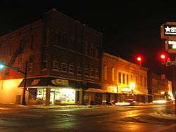 Elwood Downtown Historic District at night | |
 Location of Elwood in Madison County and Tipton County, Indiana. | |
| Coordinates: 40°16′27″N 85°50′17″W / 40.27417°N 85.83806°WCoordinates: 40°16′27″N 85°50′17″W / 40.27417°N 85.83806°W | |
| Country | United States |
| State | Indiana |
| Counties | Madison, Tipton |
| Government | |
| • Mayor | Todd Jones (D) |
| Area[1] | |
| • Total | 3.72 sq mi (9.63 km2) |
| • Land | 3.72 sq mi (9.63 km2) |
| • Water | 0.00 sq mi (0.00 km2) |
| Elevation[2] | 860 ft (262 m) |
| Population (2010)[3] | |
| • Total | 8,614 |
| • Estimate (2016)[4] | 8,416 |
| • Density | 2,263.58/sq mi (873.87/km2) |
| Time zone | UTC-5 (EST) |
| • Summer (DST) | UTC-4 (EDT) |
| ZIP code | 46036 |
| Area code(s) | 765 |
| FIPS code | 18-21070[5] |
| GNIS feature ID | 434144 |
Elwood is a city in Madison and Tipton counties in the U.S. state of Indiana.[6] The Madison County portion, which includes most of the city, is part of the Anderson, Indiana Metropolitan Statistical Area, while the small portion in Tipton County is part of the Kokomo, Indiana Metropolitan Statistical Area. The population was 8,614 at the 2010 census.
History
Elwood was laid out in 1853 under the name Duck Creek.[7] It was incorporated as a city in 1891.[8]
A post office was established under the name Duck Creek in 1855, was renamed to Elwood in 1869, and has been operating since.[9]
The annual Glass Festival, held every third weekend of August, is one way in which the city tries to promote the area's history with natural gas and glass. In the years surrounding the turn of the century, Elwood, along with the nearby towns of Anderson and Gas City, was a common destination for Welsh immigrant families.
The Elwood Downtown Historic District was listed in the National Register of Historic Places in 2002.[10]
Geography
Elwood is located at 40°16′27″N 85°50′17″W / 40.27417°N 85.83806°W (40.274109, -85.838047).[11]
According to the 2010 census, Elwood has a total area of 3.77 square miles (9.76 km2), all land.[12]
Demographics
| Historical population | |||
|---|---|---|---|
| Census | Pop. | %± | |
| 1870 | 310 | — | |
| 1880 | 751 | 142.3% | |
| 1890 | 2,284 | 204.1% | |
| 1900 | 12,950 | 467.0% | |
| 1910 | 11,028 | −14.8% | |
| 1920 | 10,790 | −2.2% | |
| 1930 | 10,685 | −1.0% | |
| 1940 | 10,913 | 2.1% | |
| 1950 | 11,362 | 4.1% | |
| 1960 | 11,793 | 3.8% | |
| 1970 | 11,196 | −5.1% | |
| 1980 | 10,867 | −2.9% | |
| 1990 | 9,494 | −12.6% | |
| 2000 | 9,737 | 2.6% | |
| 2010 | 8,614 | −11.5% | |
| Est. 2016 | 8,416 | [4] | −2.3% |
| U.S. Decennial Census[13] | |||
2010 census
As of the census[3] of 2010, there were 8,614 people, 3,455 households, and 2,265 families residing in the city. The population density was 2,284.9 inhabitants per square mile (882.2/km2). There were 4,099 housing units at an average density of 1,087.3 per square mile (419.8/km2). The racial makeup of the city was 96.7% White, 0.2% African American, 0.2% Native American, 0.3% Asian, 1.0% from other races, and 1.5% from two or more races. Hispanic or Latino of any race were 3.3% of the population.
There were 3,455 households of which 33.1% had children under the age of 18 living with them, 44.8% were married couples living together, 14.8% had a female householder with no husband present, 6.0% had a male householder with no wife present, and 34.4% were non-families. 28.6% of all households were made up of individuals and 12.5% had someone living alone who was 65 years of age or older. The average household size was 2.49 and the average family size was 3.02.
The median age in the city was 38.6 years. 25.2% of residents were under the age of 18; 8.5% were between the ages of 18 and 24; 24.1% were from 25 to 44; 28.1% were from 45 to 64; and 14.1% were 65 years of age or older. The gender makeup of the city was 48.7% male and 51.3% female.
2000 census
As of the census[5] of 2000, there were 9,737 people, 3,845 households, and 2,660 families residing in the city. The population density was 2,743.1 people per square mile (1,059.0/km²). There were 4,179 housing units at an average density of 1,177.3 per square mile (454.5/km²). The racial makeup of the city was 98.33% White, 0.05% African American, 0.12% Native American, 0.25% Asian, 0.05% Pacific Islander, 0.68% from other races, and 0.52% from two or more races. Hispanic or Latino of any race were 1.64% of the population.
There were 3,845 households out of which 32.7% had children under the age of 18 living with them, 52.9% were married couples living together, 11.9% had a female householder with no husband present, and 30.8% were non-families. 26.9% of all households were made up of individuals and 12.1% had someone living alone who was 65 years of age or older. The average household size was 2.50 and the average family size was 3.00.
In the city, the population was spread out with 26.3% under the age of 18, 7.9% from 18 to 24, 28.8% from 25 to 44, 22.3% from 45 to 64, and 14.8% who were 65 years of age or older. The median age was 37 years. For every 100 females, there were 94.2 males. For every 100 females age 18 and over, there were 90.5 males.
The median income for a household in the city was $30,986, and the median income for a family was $36,239. Males had a median income of $31,527 versus $19,947 for females. The per capita income for the city was $15,402. About 11.7% of families and 15.2% of the population were below the poverty line, including 21.0% of those under age 18 and 9.4% of those age 65 or over.
Business
Red Gold, one of the nation's largest tomato processors, has a plant in Elwood, as well as tool and die shops and other small manufacturers.
Education
Elwood has a public library, a branch of the North Madison County Public Library System.[14]
Notable people
- David Canary, actor
- Jared Carter, poet
- James J. Davis, United States Secretary of Labor and U.S. Senator from Pennsylvania
- Don Mellett, newspaper editor
- John Mengelt, professional athlete, NBA
- Philip Sharp, U.S. Representative from Indiana
- Ray Still, contemporary classical oboist
- Wallace D. Wattles, writer
- Edward Willkie, Olympic wrestler
- Wendell Willkie, 1940 Republican presidential candidate
References
- ↑ "2016 U.S. Gazetteer Files". United States Census Bureau. Retrieved Jul 28, 2017.
- ↑ "US Board on Geographic Names". United States Geological Survey. 2007-10-25. Retrieved 2008-01-31.
- 1 2 "American FactFinder". United States Census Bureau. Retrieved 2012-12-11.
- 1 2 "Population and Housing Unit Estimates". Retrieved June 9, 2017.
- 1 2 "American FactFinder". United States Census Bureau. Archived from the original on 2013-09-11. Retrieved 2008-01-31.
- ↑ "Elwood, Indiana". Geographic Names Information System. United States Geological Survey. Retrieved 2016-07-22.
- ↑ Forkner, John La Rue; Dyson, Byron H. (1897). Historical Sketches and Reminiscences of Madison County, Indiana. Wilson, Humprheys & Co. p. 878.
- ↑ Forkner, John La Rue (1914). History of Madison County, Indiana: A Narrative Account of Its Historical Progress, Its People and Its Principal Interests, Volume 1. Lewis Publishing Company. p. 117.
- ↑ "Madison County". Jim Forte Postal History. Retrieved July 22, 2016.
- ↑ National Park Service (2010-07-09). "National Register Information System". National Register of Historic Places. National Park Service.
- ↑ "US Gazetteer files: 2010, 2000, and 1990". United States Census Bureau. 2011-02-12. Retrieved 2011-04-23.
- ↑ "G001 - Geographic Identifiers - 2010 Census Summary File 1". United States Census Bureau. Retrieved 2015-07-28.
- ↑ "Census of Population and Housing". Census.gov. Archived from the original on May 12, 2015. Retrieved June 4, 2015.
- ↑ "Branches". North Madison County Public Library System. Retrieved 10 March 2018.
External links
| Wikimedia Commons has media related to Elwood, Indiana. |
Municipalities and communities of Madison County, Indiana, United States | ||
|---|---|---|
| Cities | ||
| Towns | ||
| Townships | ||
| Unincorporated communities |
| |
| Footnotes | ‡This populated place also has portions in an adjacent county or counties | |
Municipalities and communities of Tipton County, Indiana, United States | ||
|---|---|---|
| Cities | ||
| Towns | ||
| Townships | ||
| Unincorporated communities | ||
| Ghost town | ||
| Footnotes | ‡This populated place also has portions in an adjacent county or counties | |
.jpg)