Speedway, Indiana
| Town of Speedway, Indiana | ||
|---|---|---|
| Town | ||
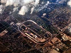 Speedway and Indianapolis Motor Speedway in 2005. | ||
| ||
| Nickname(s): "Home of the 500"; "Racing Capital of the World" | ||
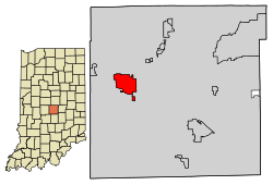 Location of Speedway in Marion County, Indiana. | ||
| Coordinates: 39°47′31″N 86°15′0″W / 39.79194°N 86.25000°WCoordinates: 39°47′31″N 86°15′0″W / 39.79194°N 86.25000°W | ||
| Country | United States | |
| State | Indiana | |
| County | Marion | |
| Township | Wayne | |
| Incorporated | 1926[1] | |
| Area[2] | ||
| • Town | 4.76 sq mi (12.33 km2) | |
| • Land | 4.76 sq mi (12.32 km2) | |
| • Water | 0.00 sq mi (0.01 km2) | |
| Elevation | 748 ft (228 m) | |
| Population (2010)[3] | ||
| • Town | 11,812 | |
| • Estimate (2016)[4] | 12,102 | |
| • Density | 2,543.51/sq mi (982.12/km2) | |
| • Metro | 2,166,632 | |
| Time zone | UTC-5 (EST) | |
| • Summer (DST) | UTC-4 (EDT) | |
| ZIP code | 46224 | |
| Area code(s) | 317 | |
| FIPS code | 18-71828[5] | |
| GNIS feature ID | 0443930[6] | |
| Website | http://www.speedwayin.gov | |

Speedway is a town in Wayne Township, Marion County, Indiana, United States. The population was 11,812 at the 2010 census.[7] Speedway is home of the Indianapolis Motor Speedway; it is an enclave of Indianapolis.
History
Speedway was laid out in 1912 as a residential suburb.[8] It took its name from the Indianapolis Motor Speedway.[9] It is an early example of a residential community planned for the industrial plants located nearby.[10] Carl G. Fisher, James A. Allison, Frank Wheeler, and Arthur Newby, founders of the Indianapolis Motor Speedway, planned the suburb of Speedway west of the track.[11] Fisher and Allison owned plants nearby that needed workers, the Prest-O-Lite factory and Allison Engine Company. The investors' goal was to create a city without horses, where residents would drive automobiles, as well as participate in creating mechanical parts for new modes of transportation.[10]
The Speedway Historic District was listed on the National Register of Historic Places in 2005.[12]
Geography
Speedway is located at 39°47′31″N 86°15′0″W / 39.79194°N 86.25000°W (39.791943, −86.249988).[13]
According to the 2010 census, Speedway has a total area of 4.768 square miles (12.35 km2), of which 4.76 square miles (12.33 km2) (or 99.83%) is land and 0.008 square miles (0.02 km2) (or 0.17%) is water.[14]
Climate
The climate in this area is characterized by hot, humid summers and generally mild to cool winters. According to the Köppen Climate Classification system, Speedway has a humid subtropical climate, Cfa on climate maps.[15] With a January daily mean of −2 °C (28 °F) however, Speedway is very close to the humid continental type.
| Climate data for Speedway | |||||||||||||
|---|---|---|---|---|---|---|---|---|---|---|---|---|---|
| Month | Jan | Feb | Mar | Apr | May | Jun | Jul | Aug | Sep | Oct | Nov | Dec | Year |
| Average high °C (°F) | 1 (34) |
4 (39) |
9 (48) |
17 (63) |
22 (72) |
27 (81) |
29 (84) |
28 (82) |
25 (77) |
18 (64) |
10 (50) |
4 (39) |
16 (61) |
| Daily mean °C (°F) | −2 (28) |
0 (32) |
4 (39) |
11 (52) |
17 (63) |
22 (72) |
24 (75) |
23 (73) |
19 (66) |
13 (55) |
5 (41) |
0 (32) |
11 (52) |
| Average low °C (°F) | −7 (19) |
−5 (23) |
0 (32) |
5 (41) |
10 (50) |
16 (61) |
18 (64) |
17 (63) |
12 (54) |
6 (43) |
0 (32) |
−4 (25) |
5 (41) |
| Average precipitation mm (inches) | 72 (2.83) |
63 (2.48) |
96 (3.78) |
94 (3.7) |
103 (4.06) |
102 (4.02) |
102 (4.02) |
84 (3.31) |
78 (3.07) |
68 (2.68) |
82 (3.23) |
73 (2.87) |
1,017 (40.04) |
| Source: [16] | |||||||||||||
Demographics
| Historical population | |||
|---|---|---|---|
| Census | Pop. | %± | |
| 1930 | 1,420 | — | |
| 1940 | 2,325 | 63.7% | |
| 1950 | 5,498 | 136.5% | |
| 1960 | 9,624 | 75.0% | |
| 1970 | 14,523 | 50.9% | |
| 1980 | 12,641 | −13.0% | |
| 1990 | 13,092 | 3.6% | |
| 2000 | 12,881 | −1.6% | |
| 2010 | 11,812 | −8.3% | |
| Est. 2016 | 12,102 | [4] | 2.5% |
| U.S. Decennial Census[17] | |||
2010 census
As of the census[3] of 2010, 11,812 people, 5,550 households, and 2,931 families resided in the town. The population density was 2,481.5 inhabitants per square mile (958.1/km2). The 6,709 housing units averaged 1,409.5 per square mile (544.2/km2). The racial makeup of the town was 74.2% White, 16.7% African American, 0.3% Native American, 2.0% Asian, 4.4% from other races, and 2.3% from two or more races. Hispanics or Latinos of any race were 7.6% of the population.
Of the 5,550 households, 26.9% had children under the age of 18 living with them, 32.4% were married couples living together, 15.3% had a female householder with no husband present, 5.2% had a male householder with no wife present, and 47.2% were not families. About 39.9% of all households were made up of individuals, and 12.9% had someone living alone who was 65 years of age or older. The average household size was 2.13 and the average family size was 2.84.
The median age in the town was 37.8 years. About 21.7% of residents were under the age of 18; 10.8% were between the ages of 18 and 24; 26.7% were from 25 to 44; 25.8% were from 45 to 64; and 14.8% were 65 years of age or older. The gender makeup of the town was 48.3% male and 51.7% female.
2000 census
As of the census[5] of 2000, 12,882 people, 6,151 households, and 3,278 families resided in the town. The 6,151 households had 24.5% with children under the age of 18 living with them, 36.6% married couples living together, 12.5% female householders with no husband present, and 46.7% not families. In the town, the population was spread out with 20.9% under the age of 18, 10.1% from 18 to 24, 31.5% from 25 to 44, 20.2% from 45 to 64, and 17.2% who were 65 years of age or older. The median age was 37 years. For every 100 females, there were 89.2 males. For every 100 females age 18 and over, there were 84.9 males.
The median income for a household in the town was $37,713, and for a family was $49,005. Males had a median income of $36,756 versus $26,954 for females. The per capita income for the town was $21,468. About 5.6% of families and 8.8% of the population were below the poverty line, including 7.7% of those under age 18 and 9.5% of those age 65 or over.
Education
- The School Town of Speedway has six campuses, including the Speedway Senior High School, and an enrollment of approximately 1,650 students.
- St Christopher School
The town has a lending library, the Speedway Public Library.[18]
Economy
In addition to the Indianapolis Motor Speedway itself, several related companies are located south of the racetrack, such as the United States Auto Club headquarters, the Dallara racecar factory, racing teams A. J. Foyt Racing, Harding Racing and Juncos Racing, and the Speedway Indoor karting racetrack. Also, Allison Transmission has a factory near them.
Notable people
- Donald Davidson, historian
- Joyce DeWitt, actress
- Barbara Higbie, jazz musician and composer[19]
Sister cities


See also
References
- ↑ "About Our Town / Speedway, IN". www.speedwayin.gov.
- ↑ "2016 U.S. Gazetteer Files". United States Census Bureau. Retrieved Jul 28, 2017.
- 1 2 "American FactFinder". United States Census Bureau. Retrieved 2012-12-11.
- 1 2 "Population and Housing Unit Estimates". Retrieved June 9, 2017.
- 1 2 "American FactFinder". United States Census Bureau. Retrieved 2008-01-31.
- ↑ "US Board on Geographic Names". United States Geological Survey. 2007-10-25. Retrieved 2008-01-31.
- ↑ "Profile of General Population and Housing Characteristics: 2010 Demographic Profile Data (DP-1): Speedway town, Indiana". U.S. Census Bureau, American Factfinder. Retrieved February 13, 2012.
- ↑ Bodenhamer, David J.; Barrows, Robert G. (November 22, 1994). The Encyclopedia of Indianapolis. Indiana University Press. p. 1284. ISBN 0-253-11249-4.
- ↑ Baker, Ronald L. (October 1995). From Needmore to Prosperity: Hoosier Place Names in Folklore and History. Indiana University Press. p. 308. ISBN 978-0-253-32866-3.
...named the city for "Speedway Course"...
- 1 2 "Speedway Historic District". nps.gov. Retrieved February 4, 2015.
- ↑ "Feel the Need for Speed in Indy". nps.gov. Retrieved February 4, 2015.
- ↑ National Park Service (2010-07-09). "National Register Information System". National Register of Historic Places. National Park Service.
- ↑ "US Gazetteer files: 2010, 2000, and 1990". United States Census Bureau. 2011-02-12. Retrieved 2011-04-23.
- ↑ "G001 - Geographic Identifiers - 2010 Census Summary File 1". United States Census Bureau. Retrieved 2015-07-25.
- ↑ "Speedway, Indiana Köppen Climate Classification (Weatherbase)". Weatherbase.
- ↑ "Speedway, Indiana Temperature Averages". Weatherbase. Retrieved 28 April 2015.
- ↑ "Census of Population and Housing". Census.gov. Retrieved June 4, 2015.
- ↑ "Indiana public library directory" (PDF). Indiana State Library. Retrieved 10 March 2018.
- ↑ Washington Post, November 23, 1990
External links
Municipalities and communities of Marion County, Indiana, United States | ||
|---|---|---|
| Excluded cities (Unigov) | ||
| Excluded town (Unigov) | ||
| Townships | ||
| Included towns (Unigov) | ||
| Footnotes | ‡ Part of Cumberland is in Hancock County. Only the portion in Marion County is subject to Unigov as an included town. | |
.jpg)
| Authority control |
|---|