Fall Creek Township, Hamilton County, Indiana
| Fall Creek Township | |
|---|---|
| Township | |
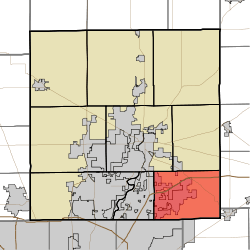 Location in Hamilton County | |
| Coordinates: 39°57′36″N 85°55′49″W / 39.96000°N 85.93028°WCoordinates: 39°57′36″N 85°55′49″W / 39.96000°N 85.93028°W | |
| Country | United States |
| State | Indiana |
| County | Hamilton |
| Government | |
| • Type | Indiana township |
| • Trustee | Doug Allman |
| Area | |
| • Total | 35.77 sq mi (92.6 km2) |
| • Land | 33.67 sq mi (87.2 km2) |
| • Water | 2.09 sq mi (5.4 km2) 5.84% |
| Elevation | 830 ft (253 m) |
| Population (2010) | |
| • Total | 51,613 |
| • Density | 1,532.8/sq mi (591.8/km2) |
| Time zone | EST |
| Area code(s) | 317 |
| GNIS feature ID | 0453290 |
Fall Creek Township is one of nine townships in Hamilton County, Indiana, United States. As of the 2010 census, its population was 51,613 and it contained 17,542 housing units.[1]
History
Fall Creek Township was organized in 1833.[2]
Geography
According to the 2010 census, the township has a total area of 35.77 square miles (92.6 km2), of which 33.67 square miles (87.2 km2) (or 94.13%) is land and 2.09 square miles (5.4 km2) (or 5.84%) is water.[1] The streams of Bee Camp Creek, Bills Branch, Britton Branch, Flatfork Creek, High Ditch, Lowery Creek, Mount Zion Branch, Mud Creek, Sand Creek, Thorpe Creek, Thor Run, and William Lehr Ditch run through this township.
Cities and towns
- Noblesville (southeast and far east edges of Noblesville)
- Fishers (east half of Fishers)
Unincorporated towns
- Ashwood
- Bradford Court
- Breakwater
- Bridgewater
- Britton Ridge
- Brooks
- Brooks Crossing
- Brookston Place
- Bucks Creek
- Carefree Estates
- Chateau Court
- Chestnut Hill
- Collingwood
- Crosswinds At Windermere
- Cumberland Ridge
- Cumberland Woods
- Devore Place
- Forest Knoll
- Geist Woods
- Glen Abbey At Windermere
- Gray Eagle
- Haig Point
- Hawthorn Hills
- Heather Point
- Heritage Green
- Highland Springs
- Hillsborough
- Lakeside Green
- Luxhaven
- Masthead
- Olio
- Plantana
- Pleasant View
- Quaker Ridge
- Sail Place
- Sand Creek Woods
- Sandstone Lakes
- Sandstone Ridge
- Sandstone Woods
- Sawgrass
- Spyglass Hill
- Sweetbriar
- The Anchorage
- The Hawthorns
- The Portage
- The Springs of Cambridge
- Thorny Ridge
- Tremont
- Turner Grove
- Valley Farms Estates
- Windermere Pointe
- Windermere Villas
- Windjammer
- Woods Edge
(This list is based on USGS data and may include former settlements.)
Adjacent townships
- Wayne Township (north)
- Green Township, Madison County (east)
- Vernon Township, Hancock County (southeast)
- Lawrence Township, Marion County (southwest)
- Delaware Township (west)
- Noblesville Township (northwest)
Cemeteries
The township contains eight cemeteries: Arnett, Bethlehem, Brooks, Helm, Highland, Lowery, McKay and Mount Zion.
Major highways
Education
Fall Creek Township residents may obtain a free library card from the Hamilton East Public Library in Noblesville.[3]
References
- "Fall Creek Township, Hamilton County, Indiana". Geographic Names Information System. United States Geological Survey. Retrieved 2009-09-24.
- United States Census Bureau cartographic boundary files
- 1 2 "Population, Housing Units, Area, and Density: 2010 - County -- County Subdivision and Place -- 2010 Census Summary File 1". United States Census. Retrieved 2013-05-10.
- ↑ Haines, John F. (1915). History of Hamilton County, Indiana: Her People, Industries And Institutions, Volume 1. B.F. Bowen & Co. p. 166.
- ↑ "How do I get a library card?". Hamilton East Public Library. Retrieved 7 March 2018.
External links
Municipalities and communities of Hamilton County, Indiana, United States | ||
|---|---|---|
| Cities | ||
| Towns | ||
| Townships | ||
| Unincorporated communities | ||
| Footnotes | ‡This populated place also has portions in an adjacent county or counties | |