Villefranche-le-Château
| Villefranche-le-Château | |
|---|---|
| Commune | |
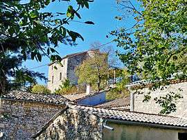 The château of Villefranche-le-Château | |
 Villefranche-le-Château Location within Auvergne-Rhône-Alpes region  Villefranche-le-Château | |
| Coordinates: 44°13′16″N 5°31′23″E / 44.221°N 5.523°ECoordinates: 44°13′16″N 5°31′23″E / 44.221°N 5.523°E | |
| Country | France |
| Region | Auvergne-Rhône-Alpes |
| Department | Drôme |
| Arrondissement | Nyons |
| Canton | Nyons et Baronnies |
| Intercommunality | Hautes Baronnies |
| Government | |
| • Mayor (2008–2014) | Éliane Gauthier |
| Area1 | 7.42 km2 (2.86 sq mi) |
| Population (2008)2 | 23 |
| • Density | 3.1/km2 (8.0/sq mi) |
| Time zone | UTC+1 (CET) |
| • Summer (DST) | UTC+2 (CEST) |
| INSEE/Postal code | 26375 /26560 |
| Elevation |
783–1,364 m (2,569–4,475 ft) (avg. 832 m or 2,730 ft) |
|
1 French Land Register data, which excludes lakes, ponds, glaciers > 1 km2 (0.386 sq mi or 247 acres) and river estuaries. 2 Population without double counting: residents of multiple communes (e.g., students and military personnel) only counted once. | |
Villefranche-le-Château is a commune in the Drôme department in southeastern France.
Population
| Historical population | ||
|---|---|---|
| Year | Pop. | ±% |
| 1911 | 65 | — |
| 1962 | 21 | −67.7% |
| 1968 | 25 | +19.0% |
| 1975 | 22 | −12.0% |
| 1982 | 15 | −31.8% |
| 1990 | 20 | +33.3% |
| 1999 | 21 | +5.0% |
| 2008 | 23 | +9.5% |
See also
References
| Wikimedia Commons has media related to Villefranche-le-Château. |
This article is issued from
Wikipedia.
The text is licensed under Creative Commons - Attribution - Sharealike.
Additional terms may apply for the media files.