Sahune
| Sahune | |
|---|---|
| Commune | |
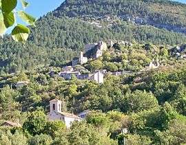 A view of the church and the old village | |
 Sahune Location within Auvergne-Rhône-Alpes region  Sahune | |
| Coordinates: 44°24′56″N 5°16′05″E / 44.4156°N 5.2681°ECoordinates: 44°24′56″N 5°16′05″E / 44.4156°N 5.2681°E | |
| Country | France |
| Region | Auvergne-Rhône-Alpes |
| Department | Drôme |
| Arrondissement | Nyons |
| Canton | Nyons et Baronnies |
| Intercommunality | Val d'Eygues |
| Government | |
| • Mayor (2008–2014) | André Felix |
| Area1 | 16.55 km2 (6.39 sq mi) |
| Population (2008)2 | 312 |
| • Density | 19/km2 (49/sq mi) |
| Time zone | UTC+1 (CET) |
| • Summer (DST) | UTC+2 (CEST) |
| INSEE/Postal code | 26288 /26510 |
| Elevation |
331–1,000 m (1,086–3,281 ft) (avg. 361 m or 1,184 ft) |
|
1 French Land Register data, which excludes lakes, ponds, glaciers > 1 km2 (0.386 sq mi or 247 acres) and river estuaries. 2 Population without double counting: residents of multiple communes (e.g., students and military personnel) only counted once. | |
Sahune is a commune in the Drôme department in southeastern France.
Population
| Historical population | ||
|---|---|---|
| Year | Pop. | ±% |
| 1911 | 505 | — |
| 1962 | 218 | −56.8% |
| 1968 | 229 | +5.0% |
| 1975 | 242 | +5.7% |
| 1982 | 275 | +13.6% |
| 1990 | 290 | +5.5% |
| 1999 | 292 | +0.7% |
| 2008 | 312 | +6.8% |
See also
References
| Wikimedia Commons has media related to Sahune. |
This article is issued from
Wikipedia.
The text is licensed under Creative Commons - Attribution - Sharealike.
Additional terms may apply for the media files.