Saint-Pantaléon-les-Vignes
| Saint-Pantaléon-les-Vignes | ||
|---|---|---|
| Commune | ||
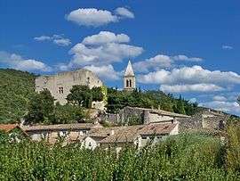 A general view of Saint-Pantaléon-les-Vignes | ||
| ||
 Saint-Pantaléon-les-Vignes Location within Auvergne-Rhône-Alpes region  Saint-Pantaléon-les-Vignes | ||
| Coordinates: 44°23′57″N 5°02′35″E / 44.3992°N 5.0431°ECoordinates: 44°23′57″N 5°02′35″E / 44.3992°N 5.0431°E | ||
| Country | France | |
| Region | Auvergne-Rhône-Alpes | |
| Department | Drôme | |
| Arrondissement | Nyons | |
| Canton | Grignan | |
| Government | ||
| • Mayor (2008–2014) | Céline Lascombes | |
| Area1 | 8.31 km2 (3.21 sq mi) | |
| Population (2008)2 | 428 | |
| • Density | 52/km2 (130/sq mi) | |
| Time zone | UTC+1 (CET) | |
| • Summer (DST) | UTC+2 (CEST) | |
| INSEE/Postal code | 26322 /26770 | |
| Elevation |
260–526 m (853–1,726 ft) (avg. 250 m or 820 ft) | |
|
1 French Land Register data, which excludes lakes, ponds, glaciers > 1 km2 (0.386 sq mi or 247 acres) and river estuaries. 2 Population without double counting: residents of multiple communes (e.g., students and military personnel) only counted once. | ||
.svg.png)
Saint-Pantaléon-les-Vignes is a commune in the Drôme department in southeastern France.
Population
| Historical population | ||
|---|---|---|
| Year | Pop. | ±% |
| 1851 | 405 | — |
| 1911 | 299 | −26.2% |
| 1962 | 215 | −28.1% |
| 1968 | 234 | +8.8% |
| 1975 | 259 | +10.7% |
| 1982 | 287 | +10.8% |
| 1990 | 319 | +11.1% |
| 1999 | 305 | −4.4% |
| 2008 | 428 | +40.3% |
See also
References
| Wikimedia Commons has media related to Saint-Pantaléon-les-Vignes. |
This article is issued from
Wikipedia.
The text is licensed under Creative Commons - Attribution - Sharealike.
Additional terms may apply for the media files.