Montjoyer
| Montjoyer | |
|---|---|
| Commune | |
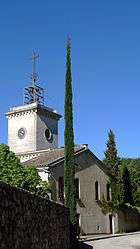 Cistercian abbey of Notre-Dame d'Aiguebelle | |
 Montjoyer Location within Auvergne-Rhône-Alpes region  Montjoyer | |
| Coordinates: 44°28′38″N 4°51′10″E / 44.4772°N 4.8528°ECoordinates: 44°28′38″N 4°51′10″E / 44.4772°N 4.8528°E | |
| Country | France |
| Region | Auvergne-Rhône-Alpes |
| Department | Drôme |
| Arrondissement | Nyons |
| Canton | Grignan |
| Government | |
| • Mayor (2008–2014) | Bernard Régnier |
| Area1 | 18.02 km2 (6.96 sq mi) |
| Population (2008)2 | 277 |
| • Density | 15/km2 (40/sq mi) |
| Time zone | UTC+1 (CET) |
| • Summer (DST) | UTC+2 (CEST) |
| INSEE/Postal code | 26203 /26230 |
| Elevation | 200–472 m (656–1,549 ft) |
|
1 French Land Register data, which excludes lakes, ponds, glaciers > 1 km2 (0.386 sq mi or 247 acres) and river estuaries. 2 Population without double counting: residents of multiple communes (e.g., students and military personnel) only counted once. | |
Montjoyer is a commune in the Drôme department in southeastern France.
Population
| Historical population | ||
|---|---|---|
| Year | Pop. | ±% |
| 1911 | 362 | — |
| 1962 | 173 | −52.2% |
| 1968 | 179 | +3.5% |
| 1975 | 159 | −11.2% |
| 1982 | 176 | +10.7% |
| 1990 | 198 | +12.5% |
| 1999 | 222 | +12.1% |
| 2008 | 277 | +24.8% |
See also
References
| Wikimedia Commons has media related to Montjoyer. |
This article is issued from
Wikipedia.
The text is licensed under Creative Commons - Attribution - Sharealike.
Additional terms may apply for the media files.