Sainte-Eulalie-en-Royans
| Sainte-Eulalie-en-Royans | |
|---|---|
| Commune | |
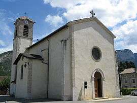 The church of Sainte-Eulalie-en-Royans | |
 Sainte-Eulalie-en-Royans Location within Auvergne-Rhône-Alpes region  Sainte-Eulalie-en-Royans | |
| Coordinates: 45°02′54″N 5°20′32″E / 45.0483°N 5.3422°ECoordinates: 45°02′54″N 5°20′32″E / 45.0483°N 5.3422°E | |
| Country | France |
| Region | Auvergne-Rhône-Alpes |
| Department | Drôme |
| Arrondissement | Die |
| Canton | Vercors-Monts du Matin |
| Intercommunality | Le Pays du Royans |
| Government | |
| • Mayor (2008–2014) | Jean-Marc Estassy |
| Area1 | 6.14 km2 (2.37 sq mi) |
| Population (2008)2 | 517 |
| • Density | 84/km2 (220/sq mi) |
| Time zone | UTC+1 (CET) |
| • Summer (DST) | UTC+2 (CEST) |
| INSEE/Postal code | 26302 /26190 |
| Elevation |
178–1,053 m (584–3,455 ft) (avg. 286 m or 938 ft) |
|
1 French Land Register data, which excludes lakes, ponds, glaciers > 1 km2 (0.386 sq mi or 247 acres) and river estuaries. 2 Population without double counting: residents of multiple communes (e.g., students and military personnel) only counted once. | |
Sainte-Eulalie-en-Royans is a French commune in the Drôme department in southeastern the region Auvergne-Rhone-Alpes.
Population
| Historical population | ||
|---|---|---|
| Year | Pop. | ±% |
| 1911 | 262 | — |
| 1962 | 240 | −8.4% |
| 1968 | 282 | +17.5% |
| 1975 | 360 | +27.7% |
| 1982 | 386 | +7.2% |
| 1990 | 402 | +4.1% |
| 1999 | 507 | +26.1% |
| 2008 | 517 | +2.0% |
Geography
Sainte-Eulalie-en-Royans is located 7 km northeast of Saint-Jean-en-Royans (capital of the canton) and 34 km east of Romans-sur-Isere.
The bordering communes are Pont-en-Royans, Saint-Laurent-en-Royans and Échevis.
Remarkable Geographical Sites
The "Réculée des Grands Goulets" is a remarkable geological site of 1,645.95 hectares, crossed by the Vernaison, which is located in the towns of Châtelus (in the place called Grands Goulets), La Chapelle-en-Vercors, Échevis, Sainte-Eulalie-en-Royans, Saint-Julien-en-Vercors, Saint-Laurent-en-Royans, Saint-Martin-en-Vercors and Pont-en-Royans. In 2014, it was classified in the "Inventory of Geological Heritage"»[1].
History
- January 9, 1965: "Sainte-Eulalie" was changed to the longer "Sainte-Eulalie-en-Royans."[2]
See also
References
- ↑ Inventaire du patrimoine géologique : résultats, Ministère de l'Environnement, de l'Énergie et de la Mer - DREAL Auvergne-Rhône-Alpes, 24 janvier 2014 (mis à jour le 31 mars 2015), accès le 23 septembre 2016.
- ↑ Décret du 5 janvier 1965 portant changement de noms de communes, JORF No. 7 du 9 janvier 1965, sur Légifrance.
| Wikimedia Commons has media related to Sainte-Eulalie-en-Royans. |