La Roche-sur-Grane
| La Roche-sur-Grane | |
|---|---|
| Commune | |
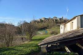 The village of La Roche-sur-Grane | |
 La Roche-sur-Grane Location within Auvergne-Rhône-Alpes region  La Roche-sur-Grane | |
| Coordinates: 44°41′00″N 4°56′28″E / 44.6833°N 4.9411°ECoordinates: 44°41′00″N 4°56′28″E / 44.6833°N 4.9411°E | |
| Country | France |
| Region | Auvergne-Rhône-Alpes |
| Department | Drôme |
| Arrondissement | Die |
| Canton | Crest |
| Intercommunality | Val de Drôme |
| Government | |
| • Mayor (2008–2014) | Christian Bonnet |
| Area1 | 12.23 km2 (4.72 sq mi) |
| Population (2008)2 | 155 |
| • Density | 13/km2 (33/sq mi) |
| Time zone | UTC+1 (CET) |
| • Summer (DST) | UTC+2 (CEST) |
| INSEE/Postal code | 26277 /26400 |
| Elevation |
198–497 m (650–1,631 ft) (avg. 220 m or 720 ft) |
|
1 French Land Register data, which excludes lakes, ponds, glaciers > 1 km2 (0.386 sq mi or 247 acres) and river estuaries. 2 Population without double counting: residents of multiple communes (e.g., students and military personnel) only counted once. | |
La Roche-sur-Grane is a commune in the Drôme department in southeastern France.
Population
| Historical population | ||
|---|---|---|
| Year | Pop. | ±% |
| 1911 | 202 | — |
| 1962 | 91 | −55.0% |
| 1968 | 105 | +15.4% |
| 1975 | 113 | +7.6% |
| 1982 | 118 | +4.4% |
| 1990 | 137 | +16.1% |
| 1999 | 121 | −11.7% |
| 2008 | 155 | +28.1% |
See also
References
| Wikimedia Commons has media related to La Roche-sur-Grane. |
This article is issued from
Wikipedia.
The text is licensed under Creative Commons - Attribution - Sharealike.
Additional terms may apply for the media files.