La Coucourde
| La Coucourde | ||
|---|---|---|
| Commune | ||
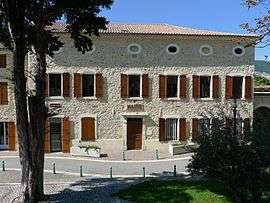 The town hall in La Coucourde | ||
| ||
 La Coucourde Location within Auvergne-Rhône-Alpes region  La Coucourde | ||
| Coordinates: 44°39′05″N 4°47′03″E / 44.6514°N 4.7842°ECoordinates: 44°39′05″N 4°47′03″E / 44.6514°N 4.7842°E | ||
| Country | France | |
| Region | Auvergne-Rhône-Alpes | |
| Department | Drôme | |
| Arrondissement | Nyons | |
| Canton | Montélimar-1 | |
| Intercommunality | Montélimar-Sésame | |
| Government | ||
| • Mayor (2008–2014) | Jean-Luc Zanon | |
| Area1 | 11.15 km2 (4.31 sq mi) | |
| Population (2008)2 | 960 | |
| • Density | 86/km2 (220/sq mi) | |
| Time zone | UTC+1 (CET) | |
| • Summer (DST) | UTC+2 (CEST) | |
| INSEE/Postal code | 26106 /26740 | |
| Elevation | 71–395 m (233–1,296 ft) | |
|
1 French Land Register data, which excludes lakes, ponds, glaciers > 1 km2 (0.386 sq mi or 247 acres) and river estuaries. 2 Population without double counting: residents of multiple communes (e.g., students and military personnel) only counted once. | ||
.svg.png)
La Coucourde is a commune in the Drôme department in southeastern France. It housed the Horus community until 1997.
Population
| Historical population | ||
|---|---|---|
| Year | Pop. | ±% |
| 1911 | 401 | — |
| 1962 | 513 | +27.9% |
| 1968 | 522 | +1.8% |
| 1975 | 470 | −10.0% |
| 1982 | 563 | +19.8% |
| 1990 | 687 | +22.0% |
| 1999 | 749 | +9.0% |
| 2008 | 960 | +28.2% |
See also
References
| Wikimedia Commons has media related to La Coucourde. |
This article is issued from
Wikipedia.
The text is licensed under Creative Commons - Attribution - Sharealike.
Additional terms may apply for the media files.