Les Granges-Gontardes
| Les Granges-Gontardes | |
|---|---|
| Commune | |
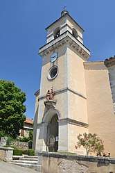 The church in Les Granges-Gontardes | |
 Les Granges-Gontardes Location within Auvergne-Rhône-Alpes region  Les Granges-Gontardes | |
| Coordinates: 44°25′00″N 4°45′50″E / 44.4167°N 4.7639°ECoordinates: 44°25′00″N 4°45′50″E / 44.4167°N 4.7639°E | |
| Country | France |
| Region | Auvergne-Rhône-Alpes |
| Department | Drôme |
| Arrondissement | Nyons |
| Canton | Grignan |
| Government | |
| • Mayor (2008–2014) | Michel Aproyan |
| Area1 | 7.26 km2 (2.80 sq mi) |
| Population (2008)2 | 565 |
| • Density | 78/km2 (200/sq mi) |
| Time zone | UTC+1 (CET) |
| • Summer (DST) | UTC+2 (CEST) |
| INSEE/Postal code | 26145 /26290 |
| Elevation | 60–175 m (197–574 ft) |
|
1 French Land Register data, which excludes lakes, ponds, glaciers > 1 km2 (0.386 sq mi or 247 acres) and river estuaries. 2 Population without double counting: residents of multiple communes (e.g., students and military personnel) only counted once. | |
Les Granges-Gontardes is a commune in the Drôme department in southeastern France.
Population
| Historical population | ||
|---|---|---|
| Year | Pop. | ±% |
| 1962 | 211 | — |
| 1968 | 304 | +44.1% |
| 1975 | 302 | −0.7% |
| 1982 | 411 | +36.1% |
| 1990 | 511 | +24.3% |
| 1999 | 559 | +9.4% |
| 2008 | 565 | +1.1% |
See also
References
| Wikimedia Commons has media related to Les Granges-Gontardes. |
| Authority control |
|---|
This article is issued from
Wikipedia.
The text is licensed under Creative Commons - Attribution - Sharealike.
Additional terms may apply for the media files.