Ratières
| Ratières | |
|---|---|
| Commune | |
 A view within the village of Ratières | |
 Ratières Location within Auvergne-Rhône-Alpes region  Ratières | |
| Coordinates: 45°10′57″N 4°58′08″E / 45.1825°N 4.9689°ECoordinates: 45°10′57″N 4°58′08″E / 45.1825°N 4.9689°E | |
| Country | France |
| Region | Auvergne-Rhône-Alpes |
| Department | Drôme |
| Arrondissement | Valence |
| Canton | Drôme des collines |
| Intercommunality | Porte de DrômArdèche |
| Government | |
| • Mayor (2014–2020) | David Bouvier |
| Area1 | 9.01 km2 (3.48 sq mi) |
| Population (2013)2 | 264 |
| • Density | 29/km2 (76/sq mi) |
| Time zone | UTC+1 (CET) |
| • Summer (DST) | UTC+2 (CEST) |
| INSEE/Postal code | 26259 /26330 |
| Elevation | 232–449 m (761–1,473 ft) |
|
1 French Land Register data, which excludes lakes, ponds, glaciers > 1 km2 (0.386 sq mi or 247 acres) and river estuaries. 2 Population without double counting: residents of multiple communes (e.g., students and military personnel) only counted once. | |
Ratières is a commune in the Drôme department in southeastern France.
Population
| Historical population | ||
|---|---|---|
| Year | Pop. | ±% |
| 1911 | 314 | — |
| 1962 | 217 | −30.9% |
| 1968 | 222 | +2.3% |
| 1975 | 191 | −14.0% |
| 1982 | 182 | −4.7% |
| 1990 | 206 | +13.2% |
| 1999 | 255 | +23.8% |
| 2008 | 274 | +7.5% |
Sights
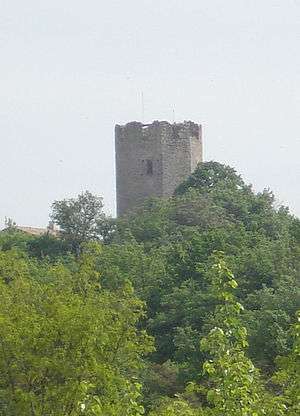
Tour de Ratières
- The Tour de Ratières is the 14th keep of a castle. Extensive modern gardens designed by Paolo Tonini are in the grounds.
See also
References
| Wikimedia Commons has media related to Ratières. |
This article is issued from
Wikipedia.
The text is licensed under Creative Commons - Attribution - Sharealike.
Additional terms may apply for the media files.