Izon-la-Bruisse
| Izon-la-Bruisse | |
|---|---|
| Commune | |
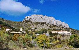 A general view of the village of Izon-la-Bruisse | |
 Izon-la-Bruisse Location within Auvergne-Rhône-Alpes region  Izon-la-Bruisse | |
| Coordinates: 44°15′22″N 5°35′39″E / 44.2561°N 5.5942°ECoordinates: 44°15′22″N 5°35′39″E / 44.2561°N 5.5942°E | |
| Country | France |
| Region | Auvergne-Rhône-Alpes |
| Department | Drôme |
| Arrondissement | Nyons |
| Canton | Nyons et Baronnies |
| Intercommunality | Hautes Baronnies |
| Government | |
| • Mayor (2008–2014) | André Mathieu |
| Area1 | 14.65 km2 (5.66 sq mi) |
| Population (2008)2 | 11 |
| • Density | 0.75/km2 (1.9/sq mi) |
| Time zone | UTC+1 (CET) |
| • Summer (DST) | UTC+2 (CEST) |
| INSEE/Postal code | 26150 /26560 |
| Elevation |
773–1,532 m (2,536–5,026 ft) (avg. 1,110 m or 3,640 ft) |
|
1 French Land Register data, which excludes lakes, ponds, glaciers > 1 km2 (0.386 sq mi or 247 acres) and river estuaries. 2 Population without double counting: residents of multiple communes (e.g., students and military personnel) only counted once. | |
Izon-la-Bruisse is a commune in the Drôme department in southeastern France.
Population
| Historical population | ||
|---|---|---|
| Year | Pop. | ±% |
| 1911 | 67 | — |
| 1962 | 10 | −85.1% |
| 1968 | 5 | −50.0% |
| 1975 | 5 | +0.0% |
| 1982 | 8 | +60.0% |
| 1990 | 6 | −25.0% |
| 1999 | 14 | +133.3% |
| 2008 | 11 | −21.4% |
See also
References
| Wikimedia Commons has media related to Izon-la-Bruisse. |
This article is issued from
Wikipedia.
The text is licensed under Creative Commons - Attribution - Sharealike.
Additional terms may apply for the media files.