Eyroles
| Eyroles | |
|---|---|
| Commune | |
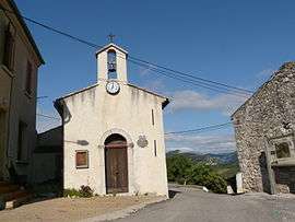 The church of the village of Eyroles | |
 Eyroles Location within Auvergne-Rhône-Alpes region  Eyroles | |
| Coordinates: 44°25′05″N 5°13′39″E / 44.4181°N 5.2275°ECoordinates: 44°25′05″N 5°13′39″E / 44.4181°N 5.2275°E | |
| Country | France |
| Region | Auvergne-Rhône-Alpes |
| Department | Drôme |
| Arrondissement | Nyons |
| Canton | Nyons et Baronnies |
| Intercommunality | Val d'Eygues |
| Government | |
| • Mayor (2008–2014) | Jean-Paul Chastan |
| Area1 | 8.75 km2 (3.38 sq mi) |
| Population (2008)2 | 22 |
| • Density | 2.5/km2 (6.5/sq mi) |
| Time zone | UTC+1 (CET) |
| • Summer (DST) | UTC+2 (CEST) |
| INSEE/Postal code | 26130 /26110 |
| Elevation | 380–805 m (1,247–2,641 ft) |
|
1 French Land Register data, which excludes lakes, ponds, glaciers > 1 km2 (0.386 sq mi or 247 acres) and river estuaries. 2 Population without double counting: residents of multiple communes (e.g., students and military personnel) only counted once. | |
Eyroles is a commune in the Drôme department in the Auvergne-Rhône-Alpes region in southeastern France.
Population
| Historical population | ||
|---|---|---|
| Year | Pop. | ±% |
| 1911 | 38 | — |
| 1962 | 26 | −31.6% |
| 1968 | 29 | +11.5% |
| 1975 | 18 | −37.9% |
| 1982 | 20 | +11.1% |
| 1990 | 20 | +0.0% |
| 1999 | 17 | −15.0% |
| 2008 | 22 | +29.4% |
See also
References
| Wikimedia Commons has media related to Eyroles. |
This article is issued from
Wikipedia.
The text is licensed under Creative Commons - Attribution - Sharealike.
Additional terms may apply for the media files.