La Rochette-du-Buis
| La Rochette-du-Buis | |
|---|---|
| Commune | |
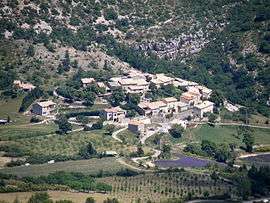 A general view of La Rochette-du-Buis | |
 La Rochette-du-Buis Location within Auvergne-Rhône-Alpes region  La Rochette-du-Buis | |
| Coordinates: 44°16′12″N 5°25′16″E / 44.27°N 5.4211°ECoordinates: 44°16′12″N 5°25′16″E / 44.27°N 5.4211°E | |
| Country | France |
| Region | Auvergne-Rhône-Alpes |
| Department | Drôme |
| Arrondissement | Nyons |
| Canton | Nyons et Baronnies |
| Intercommunality | Pays du Buis-les-Baronnies |
| Government | |
| • Mayor (2008–2014) | Gérard Argaud |
| Area1 | 11.06 km2 (4.27 sq mi) |
| Population (2008)2 | 68 |
| • Density | 6.1/km2 (16/sq mi) |
| Time zone | UTC+1 (CET) |
| • Summer (DST) | UTC+2 (CEST) |
| INSEE/Postal code | 26279 /26170 |
| Elevation |
640–1,302 m (2,100–4,272 ft) (avg. 763 m or 2,503 ft) |
|
1 French Land Register data, which excludes lakes, ponds, glaciers > 1 km2 (0.386 sq mi or 247 acres) and river estuaries. 2 Population without double counting: residents of multiple communes (e.g., students and military personnel) only counted once. | |
La Rochette-du-Buis is a commune in the Drôme department in southeastern France.
Population
| Historical population | ||
|---|---|---|
| Year | Pop. | ±% |
| 1911 | 239 | — |
| 1962 | 103 | −56.9% |
| 1968 | 105 | +1.9% |
| 1975 | 63 | −40.0% |
| 1982 | 61 | −3.2% |
| 1990 | 59 | −3.3% |
| 1999 | 65 | +10.2% |
| 2008 | 68 | +4.6% |
See also
References
| Wikimedia Commons has media related to La Rochette-du-Buis. |
This article is issued from
Wikipedia.
The text is licensed under Creative Commons - Attribution - Sharealike.
Additional terms may apply for the media files.