Montmaur-en-Diois
| Montmaur-en-Diois | |
|---|---|
| Commune | |
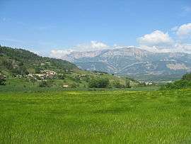 A general view of Montmaur-en-Diois | |
 Montmaur-en-Diois Location within Auvergne-Rhône-Alpes region  Montmaur-en-Diois | |
| Coordinates: 44°40′37″N 5°22′48″E / 44.6769°N 5.38°ECoordinates: 44°40′37″N 5°22′48″E / 44.6769°N 5.38°E | |
| Country | France |
| Region | Auvergne-Rhône-Alpes |
| Department | Drôme |
| Arrondissement | Die |
| Canton | Le Diois |
| Intercommunality | Diois |
| Government | |
| • Mayor (2008–2014) | Jean-Paul Keller |
| Area1 | 12.8 km2 (4.9 sq mi) |
| Population (2008)2 | 80 |
| • Density | 6.3/km2 (16/sq mi) |
| Time zone | UTC+1 (CET) |
| • Summer (DST) | UTC+2 (CEST) |
| INSEE/Postal code | 26205 /26150 |
| Elevation | 459–1,274 m (1,506–4,180 ft) |
|
1 French Land Register data, which excludes lakes, ponds, glaciers > 1 km2 (0.386 sq mi or 247 acres) and river estuaries. 2 Population without double counting: residents of multiple communes (e.g., students and military personnel) only counted once. | |
Montmaur-en-Diois is a commune in the Drôme department in southeastern France.
Population
| Historical population | ||
|---|---|---|
| Year | Pop. | ±% |
| 1806 | 221 | — |
| 1820 | 230 | +4.1% |
| 1876 | 256 | +11.3% |
| 1881 | 189 | −26.2% |
| 1886 | 187 | −1.1% |
| 1891 | 173 | −7.5% |
| 1896 | 162 | −6.4% |
| 1901 | 174 | +7.4% |
| 1906 | 160 | −8.0% |
| 1911 | 155 | −3.1% |
| 1921 | 121 | −21.9% |
| 1926 | 117 | −3.3% |
| 1931 | 108 | −7.7% |
| 1936 | 94 | −13.0% |
| 1946 | 84 | −10.6% |
| 1954 | 84 | +0.0% |
| 1962 | 57 | −32.1% |
| 1968 | 60 | +5.3% |
| 1975 | 59 | −1.7% |
| 1982 | 58 | −1.7% |
| 1990 | 79 | +36.2% |
| 1999 | 79 | +0.0% |
| 2008 | 80 | +1.3% |
See also
References
| Wikimedia Commons has media related to Montmaur-en-Diois. |
This article is issued from
Wikipedia.
The text is licensed under Creative Commons - Attribution - Sharealike.
Additional terms may apply for the media files.