Comps, Drôme
| Comps | ||
|---|---|---|
| Commune | ||
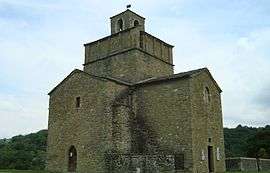 The church of Saint-Pierre and Saint-Paul, in Comps | ||
| ||
 Comps Location within Auvergne-Rhône-Alpes region  Comps | ||
| Coordinates: 44°33′12″N 5°06′47″E / 44.5533°N 5.1131°ECoordinates: 44°33′12″N 5°06′47″E / 44.5533°N 5.1131°E | ||
| Country | France | |
| Region | Auvergne-Rhône-Alpes | |
| Department | Drôme | |
| Arrondissement | Nyons | |
| Canton | Dieulefit | |
| Intercommunality | Pays de Dieulefit | |
| Government | ||
| • Mayor (2008–2014) | Roger Lafont | |
| Area1 | 11.88 km2 (4.59 sq mi) | |
| Population (2008)2 | 163 | |
| • Density | 14/km2 (36/sq mi) | |
| Time zone | UTC+1 (CET) | |
| • Summer (DST) | UTC+2 (CEST) | |
| INSEE/Postal code | 26101 /26220 | |
| Elevation | 465–959 m (1,526–3,146 ft) | |
|
1 French Land Register data, which excludes lakes, ponds, glaciers > 1 km2 (0.386 sq mi or 247 acres) and river estuaries. 2 Population without double counting: residents of multiple communes (e.g., students and military personnel) only counted once. | ||

Comps is a commune in the Drôme department in southeastern France.
Population
| Historical population | ||
|---|---|---|
| Year | Pop. | ±% |
| 1911 | 244 | — |
| 1962 | 196 | −19.7% |
| 1968 | 119 | −39.3% |
| 1975 | 104 | −12.6% |
| 1982 | 129 | +24.0% |
| 1990 | 137 | +6.2% |
| 1999 | 118 | −13.9% |
| 2008 | 163 | +38.1% |
See also
References
| Wikimedia Commons has media related to Comps (Drôme). |
This article is issued from
Wikipedia.
The text is licensed under Creative Commons - Attribution - Sharealike.
Additional terms may apply for the media files.