Le Poët-Célard
| Le Poët-Célard | |
|---|---|
| Commune | |
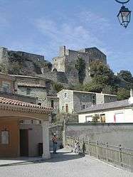 A view of the château of Le Poët-Célard | |
 Le Poët-Célard Location within Auvergne-Rhône-Alpes region  Le Poët-Célard | |
| Coordinates: 44°36′10″N 5°06′16″E / 44.6028°N 5.1044°ECoordinates: 44°36′10″N 5°06′16″E / 44.6028°N 5.1044°E | |
| Country | France |
| Region | Auvergne-Rhône-Alpes |
| Department | Drôme |
| Arrondissement | Die |
| Canton | Dieulefit |
| Intercommunality | Val de Drôme |
| Government | |
| • Mayor (2008–2014) | Jean-Louis Hilaire |
| Area1 | 8.34 km2 (3.22 sq mi) |
| Population (2008)2 | 140 |
| • Density | 17/km2 (43/sq mi) |
| Time zone | UTC+1 (CET) |
| • Summer (DST) | UTC+2 (CEST) |
| INSEE/Postal code | 26241 /26460 |
| Elevation | 351–744 m (1,152–2,441 ft) |
|
1 French Land Register data, which excludes lakes, ponds, glaciers > 1 km2 (0.386 sq mi or 247 acres) and river estuaries. 2 Population without double counting: residents of multiple communes (e.g., students and military personnel) only counted once. | |
Le Poët-Célard is a commune in the Drôme department in southeastern France.
Population
| Historical population | ||
|---|---|---|
| Year | Pop. | ±% |
| 1911 | 276 | — |
| 1962 | 148 | −46.4% |
| 1968 | 162 | +9.5% |
| 1975 | 150 | −7.4% |
| 1982 | 137 | −8.7% |
| 1990 | 142 | +3.6% |
| 1999 | 145 | +2.1% |
| 2008 | 140 | −3.4% |
See also
References
| Wikimedia Commons has media related to Le Poët-Célard. |
This article is issued from
Wikipedia.
The text is licensed under Creative Commons - Attribution - Sharealike.
Additional terms may apply for the media files.