London Borough of Hillingdon
| London Borough of Hillingdon | |||
|---|---|---|---|
| London borough | |||
| |||
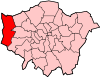
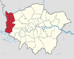 Hillingdon shown within Greater London | |||
| Sovereign state | United Kingdom | ||
| Constituent country | England | ||
| Region | London | ||
| Ceremonial county | Greater London | ||
| Created | 1 April 1965 | ||
| Admin HQ |
Hillingdon Civic Centre, Uxbridge | ||
| Government | |||
| • Type | London borough council | ||
| • Body | Hillingdon London Borough Council | ||
| • Leadership | Leader (Raymond Puddifoot)[1] (Conservative) | ||
| • Mayor | Cllr John Morgan | ||
| • London Assembly | Onkar Sahota (Lab) AM for Ealing and Hillingdon | ||
| • MPs |
Nick Hurd (Con) John McDonnell (Lab) Boris Johnson (Con) | ||
| • EU Parliament | London | ||
| Area | |||
| • Total | 115.70 km2 (44.67 sq mi) | ||
| Area rank | 203rd (of 326) | ||
| Population (mid-2017 est.) | |||
| • Total | 302,300 | ||
| • Rank | 37th (of 326) | ||
| • Density | 2,600/km2 (6,800/sq mi) | ||
| • Ethnicity[2] |
52.2% White British | ||
| Time zone | UTC (GMT) | ||
| • Summer (DST) | UTC+1 (BST) | ||
| Postcodes | HA, TW, UB, WD | ||
| Area code(s) | 01895, 01923, 020 | ||
| ONS code | 00AS | ||
| GSS code | E09000017 | ||
| Police | Metropolitan Police | ||
| Website | http://www.hillingdon.gov.uk/ | ||
The London Borough of Hillingdon (![]()
Hillingdon Council governs the borough, with its headquarters in the Civic Centre in Uxbridge. For administrative purposes, the borough is split into North and South Hillingdon. The south's former strong connection with industry has diminished since the 1980s to be replaced by a preponderantly residential suburban population; the north has remained a consistently residential suburban area. The borough's residential areas expanded with the extension of the Metropolitan Railway from Harrow on the Hill to Uxbridge in the early 20th century and the gradual establishment of stops along the line, becoming known as "Metro-land".
History
The borough was formed in 1965 from the Hayes and Harlington Urban District, Municipal Borough of Uxbridge, Ruislip-Northwood Urban District, and Yiewsley and West Drayton Urban District, all formerly in Middlesex.[4] The councils involved were initially unable to decide upon a name, with Keith Joseph suggesting "Uxbridge" in October 1963, later revised to Hillingdon.[4]
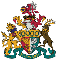
The coat of arms for the London Borough of Hillingdon was granted on 22 March 1965.[5] Between 1973 and 1978, the borough's civic centre was built in Uxbridge.[6]
The borough has been twinned with the French town of Mantes-la-Jolie and the German town of Schleswig since the Hayes & Harlington Urban District created the link in 1958.[7] The twinning programme was reviewed in 2011 and it was suggested that the link with Schleswig be ended owing to a lack of contact between the towns.[8] In December 2011, the borough decided instead to end the link with a second German town, Emden, citing administrative problems.[9]
From 2001 to 2011 the borough's population grew by 11.5% (4.4% above the England and Wales mean of 7.1%) as part of the fastest population-growth area, Greater London. By comparison Merton and Bromley grew by 4.5% and Tower Hamlets grew by 26.4%.[10] The number of households increased from 2001–2011 by 3.3%, and the average number of people per household was 2.7.[3]
Governance
Hillingdon Council

The borough is governed by an elected council, known interchangeably by the full name and as Hillingdon Council.[11] It is split into wards represented by 65 Conservative and Labour councillors.[12] A cabinet and leader are elected annually.[13] The present leader of the council is Cllr. Ray Puddifoot MBE of the Conservative Party.[1] Elections for councillors are held every four years.[13]
A Mayor is chosen yearly by councillors; the role is largely ceremonial.[14] The present mayor is Councillor John Morgan (Northwood Hills Ward), who was elected on 10th May 2018.
London Assembly
In the London assembly elections, Ealing and Hillingdon Borough form a geographical constituency with one member as there are eleven London-wide members, currently from the four biggest parties. Conservative candidate Richard Barnes won the 2000, 2004 and 2008 elections, and since the 2012 election the Labour candidate Onkar Sahota has served as the area's designated member on the London Assembly.
At the same election in 2012 Conservative mayoral candidate Boris Johnson won the largest share of Hillingdon's votes in becoming elected Mayor of London for a second term.
Government facilities
The British Government's UK Visas and Immigration has two immigration removal centres: Colnbrook Immigration Removal Centre and Harmondsworth Immigration Removal Centre in Harmondsworth.[15][16]
Wards
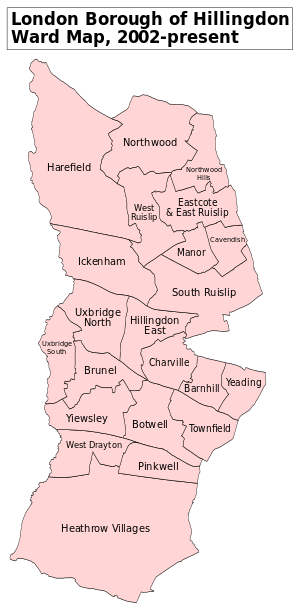
The London Borough of Hillingdon is divided into a total of 22 wards[17]:
- Barnhill
- Botwell
- Brunel
- Cavendish
- Charville
- Eastcote and East Ruislip
- Harefield
- Heathrow Villages (including Harmondsworth, Sipson and Harlington)
- Hillingdon East
- Ickenham
- Manor
- Northwood Hills
- Northwood
- Pinkwell
- South Ruislip
- Townfield
- Uxbridge North
- Uxbridge South
- West Drayton
- West Ruislip
- Yeading
- Yiewsley
The borough also includes RAF Northolt and the formerly the sites of RAF Eastcote, RAF South Ruislip, RAF West Drayton, RAF Ruislip 4MU, RAF West Ruislip and RAF Uxbridge.
| Population | ||
|---|---|---|
| Year | Pop. | ±% |
| 1801 | 9,232 | — |
| 1811 | 11,033 | +19.5% |
| 1821 | 12,788 | +15.9% |
| 1831 | 14,484 | +13.3% |
| 1841 | 18,329 | +26.5% |
| 1851 | 18,744 | +2.3% |
| 1861 | 20,672 | +10.3% |
| 1871 | 22,600 | +9.3% |
| 1881 | 24,528 | +8.5% |
| 1891 | 26,640 | +8.6% |
| 1901 | 32,548 | +22.2% |
| 1911 | 39,768 | +22.2% |
| 1921 | 58,681 | +47.6% |
| 1931 | 86,613 | +47.6% |
| 1941 | 137,278 | +58.5% |
| 1951 | 217,616 | +58.5% |
| 1961 | 226,074 | +3.9% |
| 1971 | 234,867 | +3.9% |
| 1981 | 226,256 | −3.7% |
| 1991 | 236,720 | +4.6% |
| 2001 | 242,435 | +2.4% |
| 2011 | 273,936 | +13.0% |
| Source: A Vision of Britain through time, citing Census population | ||
Demographics
52.2% of the borough's population identified themselves as White British in the 2011 census. Much of the ethnic diversity is in the south-east of the borough, in particular Hayes.
The wards where whites are not the largest race group are:
- Barnhill (partly covering eastern Hayes, south of Yeading),
- Pinkwell (mostly the area around the railway station in southern Hayes),
- Townfield (Part of eastern Hayes and west of Southall),
- Yeading (Eastern Hayes)
Whites as a whole form 60.6% of the borough, Asians 25.3%, and Blacks 7.3%. In addition, the most common language, English (81.2%), is followed by Punjabi (3.4%), Polish (1.5%), Tamil (1.4%) and Urdu (1.3%).[18]
Parks and recreation
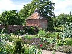
The borough maintains over 200 green spaces, totalling around 1,800 acres (730 ha).[19] As much of the area is within the Metropolitan Green Belt it was, in 2008, one of the least densely populated of all the London boroughs; open spaces range in size from the Colne Valley Regional Park by the River Colne in the north of the borough, to smaller gardens and parks such as the Norman Leddy Memorial Gardens and Lake Farm Country Park in the south of the borough.[20]
Council leader Raymond Puddifoot had given a promise that green-belt land in Hillingdon would be safe on his watch: 'I can give a categoric assurance that under this administration we will never see a threat to the green belt.'[21] In August 2012, however, Mr Puddifoot announced plans to build on green-belt (and longtime common land) site Lake Farm in the south of the borough.[22] Dismissing the discontent of residents in the south of the borough, the Conservative majority of the Council's planning committee peremptorily rubber-stamped the plans in March 2013.[23]
Harmondsworth Moor, a park owned by the borough, is administered by British Airways on behalf of the borough.[24] After British Airways planned to create a new headquarters in 1992, the airline agreed to convert a former landfill site into Harmondsworth Moor.[25]
The Grand Union Canal passes through parts of the borough, including Hayes, Uxbridge, Yiewsley and West Drayton. Ruislip Lido was built as a feeder reservoir for the canal, but was eventually disconnected and changed to become a recreational lido. Two Sites of Special Scientific Interest next to the canal, Frays Farm Meadows and Denham Lock Wood, are managed by the London Wildlife Trust.
The borough also operates children's centres, recreational areas for children of under five years of age and their families. The centres include: Barra Hall, Belmore, Cherry Lane, Colham Manor, Cornerstone, Cowley St. Laurence, Harefield, Hillside, McMillan Early Childhood Centre, Nestles Avenue, Oak Farm, and Uxbridge College (Hayes Campus).[26]
The borough owns four theatres: the Beck Theatre in Hayes (which is operated on behalf of the borough by HQ Theatres Limited),[27] the Compass Theatre in Ickenham, the Winston Churchill Theatre and Hall (part of the Manor Farm site) and the Open Air Theatre, Barra Hall Park in Hayes.
Sport and leisure
The Borough has seven Non-League football clubs:
- A.F.C. Hayes, who play at Farm Park, Hayes.
- Harefield United F.C., who play at Preston Park, Harefield.
- Hayes & Yeading United F.C., who currently play their first team games outside the borough at Maidenhead United F.C..
- Hillingdon Borough F.C. who play at the Middlesex Stadium, Ruislip.
- Northwood F.C. who play at the Northwood Park Stadium, Northwood.
- Uxbridge F.C. who play at Honeycroft, West Drayton.
- Wealdstone F.C. who play at St Georges Stadium, Ruislip.
The borough is also home to Hillingdon Outdoor Activity Centre (HOAC) a water sports and activity centre, which is also home to a number of independently run sports clubs:
Economy

Hillingdon has a large economy by national standards, ranked 14th out of 408 local area districts in Britain, and ranked 5th out of the London boroughs.[20]
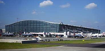
British Airways is headquartered in Waterside, Harmondsworth, in Hillingdon.[28] The building officially opened in 1998.[29] Prior to the opening of Waterside, the airline's head office was the Speedbird House at London Heathrow Airport.[30] An office of American Airlines is located at the Orient House (HAA3) within Waterside.[31]
In 2007 Cadbury Schweppes announced it would be moving to Uxbridge from Mayfair to cut costs.[32] The company later split and Cadbury plc moved to its new head office in Cadbury House in the Uxbridge Business Park in June 2008.[33]
Guoman Hotel Management (UK) Limited has its head office in the Thistle London Heathrow in West Drayton.[34][35]
British Midland International has an office in Stockley Close, West Drayton, Borough of Hillingdon.[36] In July 1999 Sir Michael Bishop formally opened the British Midland Training Centre, which is located in Stockley Close.[37] Hellenic Imperial Airways has its United Kingdom offices in the Axis House in Harlington in the London Borough of Hillingdon.[38] China Airlines has its UK office in the Hyde Park Hayes 3 (HPH3) in Hayes in the borough.[39]
One of the predecessor organisations of British Airways, British Overseas Airways Corporation had its head office in the Speedbird House.[40] The other predecessor, British European Airways had its headquarters in Ruislip,[41] as did BEA Helicopters.[40] During its existence the airline British Eagle had its head office on the grounds of Heathrow Airport.[42]
A 2017 study by Trust for London and New Policy Institute found that there is a 22% poverty rate in Hillingdon, slightly below the London-wide figure of 27%. It also found that 24% of Hillingdon’s local employees are low-paid, narrowly above the London average of 21%.[43]
Education
The borough maintains seventeen libraries: Charville, Eastcote, Harefield, Harlington, Hayes End, Hayes, Ickenham, Manor Farm, Northwood Hills, Northwood, Oak Farm, Ruislip Manor, South Ruislip, Uxbridge, West Drayton, Yeading, and Yiewsley.[44]
Hillingdon has undertaken the largest school expansion programme in London, ensuring that all children within the Borough can go to a School close to where they live.
In May 2011, Hillingdon Council received the Library Innovation of the Year award at the 2011 Bookseller Industry Awards.[45]
Also within the borough is Brunel University and Uxbridge College's Uxbridge and Hayes campuses.
Transport

National Rail and London Underground stations in the borough are:
- Eastcote tube station
- Hatton Cross tube station
- Hayes and Harlington railway station
- Heathrow Central railway station
- Heathrow Terminals 1, 2, 3 tube station
- Heathrow Terminal 4 railway station
- Heathrow Terminal 4 tube station
- Heathrow Terminal 5 station
- Hillingdon tube station
- Ickenham tube station
- Northwood Hills tube station
- Northwood tube station
- Ruislip Gardens tube station
- Ruislip Manor tube station
- Ruislip tube station
- South Ruislip station
- Uxbridge tube station
- West Ruislip station
- West Drayton railway station
In March 2011, the main forms of transport that residents used to travel to work were: driving a car or van, 34.5% of all residents aged 16–74; underground, metro, light rail, tram, 7.9%; bus, minibus or coach, 7.9%; on foot, 4.6%; train, 2.8%; work mainly at or from home, 2.6%; passenger in a car or van, 2.0%.[46]
Proposals
The council announced in June 2011 that it would be lobbying Transport for London to have the Central line extended from West Ruislip station to Uxbridge station. Such a project would require a business case approved by TfL and the completion of signal upgrade work on the Metropolitan line.[47]
The Royal Air Force station, RAF Northolt, is situated in South Ruislip near the A40 and the tube station. Most early RAF airfields were named after the nearest railway station; in this case Northolt Junction, the original name of South Ruislip station. The station has been redeveloped in recent years to house a number of additional military capabilities besides the RAF operations, and is popular with business people and politicians for private flights.[48]
Town twinning
Hillingdon is twinned with:


See also
Notes and references
- Notes
- References
- 1 2 "Councillor Raymond Puddifoot". London Borough of Hillingdon. 17 February 2011. Retrieved 4 April 2011.
- ↑ 2011 Census: Ethnic group, local authorities in England and Wales, Office for National Statistics (2012). See Classification of ethnicity in the United Kingdom for the full descriptions used in the 2011 Census.
- 1 2 "Area: Hillingdon (Local Authority)". Office for National Statistics. Retrieved 27 November 2011.
- 1 2 Cotton 1994, p.133
- ↑ "Hillingdon's coat of arms". London Borough of Hillingdon. 18 May 2010. Retrieved 24 June 2011.
- ↑ "Civic Centre" (PDF). London Borough of Hillingdon. May 2010. Retrieved 9 October 2011.
- ↑ "Twin towns". London Borough of Hillingdon. 10 May 2012. Retrieved 17 May 2012.
- ↑ Coombs, Dan (17 February 2011). "Hillingdon to axe German town twin to save cash". Uxbridge Gazette. Retrieved 17 May 2012.
- ↑ Griffith, Jack (1 December 2011). "Council cuts ties with German twin town". Uxbridge Gazette. Retrieved 17 May 2012.
- ↑ 2011 Census interactive map
- ↑ "Local government". London Borough of Hillingdon. 19 September 2008. Retrieved 24 June 2011.
- ↑ "Political parties and independents". London Borough of Hillingdon. 14 May 2010. Retrieved 24 June 2011.
- 1 2 "How the council and cabinet work". London Borough of Hillingdon. 11 May 2010. Retrieved 24 June 2011.
- ↑ "Civic protocol". London Borough of Hillingdon. 11 May 2012. Retrieved 17 May 2012.
- ↑ Colnbrook Immigration Removal Centre. UK Border Agency. Retrieved on 13 February 2010.
- ↑ Harmondsworth Immigration Removal Centre. UK Border Agency. Retrieved on 13 February 2010.
- ↑ "Postcodes in Hillingdon". www.doogal.co.uk. Retrieved 19 March 2018.
- ↑ http://www.hillingdon.gov.uk/media.jsp?mediaid=28815&filetype=pdf London Borough of Hillingdon Census Factsheets
- ↑ "Parks and open spaces". London Borough of Hillingdon. 11 January 2011. Retrieved 5 May 2011.
- 1 2 "Hillingdon profile 2008" (PDF). London Borough of Hillingdon. 2008. Retrieved 27 March 2011.
- ↑ Cracknell, James (1 August 2011). "Council going ahead with Green Belt school plan". Uxbridge Gazette. Retrieved 10 September 2013.
- ↑ Griffith, Jack (22 August 2012). "Lake Farm school plans 'due within weeks'". Uxbridge Gazette. Retrieved 12 September 2012.
- ↑ Griffith, Jack (6 March 2013). "Fury as Hillingdon Council approves green belt school at Lake Farm". Uxbridge Gazette. Retrieved 10 May 2013.
- ↑ "Harmondsworth Moor." London Borough of Hillingdon. Retrieved on 2 September 2009.
- ↑ "Contact Information." British Airways. Retrieved on 18 May 2009.
- ↑ "Children's centres in Hillingdon." London Borough of Hillingdon. Retrieved on 26 June 2010.
- ↑ "About us". Beck Theatre. Retrieved 27 March 2011.
- ↑ "Contact Information." British Airways. Retrieved on 18 May 2009.
- ↑ "Our locations." British Airways Jobs. Retrieved on 18 September 2009.
- ↑ "Blue Sky prepares for launch as PAL 737-300s are secured." Flight International. 28 January 1998. Retrieved on 14 December 2009.
- ↑ "Impressum" (Archive). American Airlines China. Retrieved on 24 April 2014. "American Airlines, Inc. Orient House (HAA3), Po Box 365, Waterside, Harmondsworth, UB7 0GB United Kingdom"
- ↑ Muspratt, Caroline (1 June 2007). "Cadbury swaps Mayfair for Uxbridge". The Daily Telegraph. Retrieved 27 April 2010.
- ↑ "Cadbury plc Confirms Strong Start to 2008". Investis. 19 June 2008. Retrieved 4 April 2011.
- ↑ "Corporate Office." Thistle Hotels. Retrieved on 28 December 2011. "The corporate office is based at Thistle London Heathrow and is situated across opposite the main reception adjacent to the Conference Centre"
- ↑ "Thistle London Heathrow." Thistle Hotels. Retrieved on 28 December 2011. "Bath Road, Longford West Drayton UB7 0EQ"
- ↑ "bmi’s company rewards." British Midland International. Retrieved on 28 December 2011. "Stockley Close, West Drayton, Middlesex, UB7 9BL"
- ↑ "the nineties." British Midland International. Retrieved on 28 December 2011.
- ↑ "Contact Us Archived 11 July 2011 at the Wayback Machine.." Hellenic Imperial Airways. Retrieved on 10 May 2011. "London / United Kingdom Hellenic Imperial Airways Axis House 242 Bath Road Harlington UB3 5AY"
- ↑ "Europe and Middle East Archived 26 September 2011 at the Wayback Machine.." China Airlines. Retrieved on 30 August 2011. "The United Kingdom 3rd Floor, West Wing, Hyde Park Hayes 3 (HPH3),11 Millington Road, Hayes, Middlesex, UB3 4AZ"
- 1 2 "World Airline Directory." Flight International. 28 September 1967. 530.
- ↑ "World Airline Directory." Flight International. 28 September 1967. 529
- ↑ "World Airline Directory." Flight International. 2 April 1964. 502.
- ↑ "London's Poverty Profile". Trust for London. Retrieved 25 July 2018.
- ↑ "Your local library". London Borough of Hillingdon. 13 January 2011. Retrieved 4 April 2011.
- ↑ Kobori, Minato (20 May 2011). "Hillingdon wins best library innovator of the year". Hillingdon & Uxbridge Times. Retrieved 25 May 2011.
- ↑ "2011 Census: QS701EW Method of travel to work, local authorities in England and Wales". Office for National Statistics. Retrieved 23 November 2013. Percentages are of all residents aged 16-74 including those not in employment. Respondents could only pick one mode, specified as the journey’s longest part by distance.
- ↑ Coombs, Dan (17 June 2011). "'Extending Central Line to Uxbridge will cut traffic'". Uxbridge Gazette. Retrieved 23 February 2016.
- ↑ "About us". Royal Air Force. 2011. Retrieved 19 November 2011.
- Bibliography
- Cotton, Carolynne. (1994) Uxbridge Past. London: Historical Publications ISBN 0-948667-30-3
External links
| Wikimedia Commons has media related to London Borough of Hillingdon. |
- Hillingdon Council
- Hillingdon Association of Voluntary Services
- Index to all Hillingdon streets
- List of parks and open spaces
- Hillingdon Council's channel on YouTube