U.S. Route 158
| ||||
|---|---|---|---|---|
 | ||||
| Route information | ||||
| Auxiliary route of US 58 | ||||
| Maintained by NCDOT | ||||
| Length | 350 mi[1] (563 km) | |||
| Existed | 1932–present | |||
| Major junctions | ||||
| West end |
| |||
|
| ||||
| East end |
| |||
| Location | ||||
| Counties | Davie, Forsyth, Guilford, Rockingham, Caswell, Person, Granville, Vance, Warren, Halifax, Northampton, Hertford, Gates, Pasquotank, Camden, Currituck, Dare | |||
| Highway system | ||||
| ||||

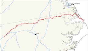
U.S. Route 158 is an east–west United States highway that runs for 350 miles (560 km) from Mocksville to Whalebone Junction in Nags Head, entirely in the state of North Carolina.
Route description
U.S. Route 158 is a parallel of U.S. Route 58. The route does not intersect its parent, instead intersecting its sibling, US 258. It currently runs for 350 miles (560 km) from Mocksville, at US 64/US 601 to Whalebone Junction in the town of Nags Head, North Carolina. A 10 miles (16 km) stretch skirts the Great Dismal Swamp.
From Mocksville, it parallels I-40 into Winston-Salem, where it merges with I-40 Business/US 421 freeway through the downtown area. Going northeast, it goes through Stokesdale then goes north around Reidsville with US 29 Business. From Reidsville, US 158 connects the northern counties of North Carolina, going through the cities and towns of Yanceyville, Roxboro, Oxford, Henderson, Roanoke Rapids, Murfreesboro, and Elizabeth City.
From NC 168 eastward, it carries traffic from the Norfolk region to the Outer Banks. Normally, the route is a four-lane undivided highway with a speed limit of 50 miles an hour in Dare County, from its eastern terminus to the Wright Memorial Bridge. Most of the route is otherwise a four-lane divided highway with a 55 miles per hour speed limit until NC 168 (which carries traffic to Chesapeake, Virginia), where it turns left at an at-grade intersection. It then returns to being undivided.
In Dare County, the highway runs in a north–south direction, although it is signed west–east. It acts as a bypass route for the Virginia Dare Trail (NC 12), which runs parallel to U.S. 158 to the east. For the entire length of the Outer Banks, US 158 is known as Croatan Highway.
History
US 158 was established in 1932, as a concurrency with NC 48 from Mocksville to Murfreesboro and NC 12, from Murfreesboro to Virginia state line. US 158 also replaced US 117 routing between Murfreesboro to Franklin, Virginia. In 1934, NC 48 and NC 12 were removed from its routing. In 1937 or 1938, US 158's western terminus moved from Depot Street to Main Street in Mocksville.[2] In 1941, US 158 swapped routes with NC 65 between Stokesdale and Reidsville. Also in same year, US 158 was rerouted east at Murfreesboro, replacing NC 30 to Camden and NC 34 crossing the Croatan Sound and ending at NC 345, near Manteo; its old alignment north of Murfreesboro became part of US 258. Between 1945-1949, US 158's western terminus moved to its current location at Main and Lexington Streets, in Mocksville; also in same time period, US 158 was moved onto new routing through Roxboro; its old alignment along Main Street became US 501A. In 1946, US 158 bypassed north of Gatesville, with its old alignment became US 158A.
Around 1951, US 158 was removed from Roanoke Island and was truncated at its current eastern terminus at Whalebone Junction, on Bodie Island; its former routing was replaced by US 64/US 264. In 1951, US 158 was placed on new bypass north of Henderson, leaving behind US 158A along its old alignment.[3] Around 1954, US 158 was placed on one-way streets in downtown Winston-Salem: westbound via Clover Dale Street, Glade Street and fifth street; eastbound via first and fourth streets. In 1955, US 158 was bypassed north of Warrenton, leaving behind US 158A along its former alignment.[4]
In 1959, US 158 was moved onto new expressway between Stratford to Marshall and Cherry Streets, in Winston-Salem. In 1960, US 158 was moved onto its current routing in Bodie Island, leaving behind US 158 Business.[5]
In 1962, US 158 was completed its transition onto the expressway in Winston-Salem, leaving behind US 158 Business. Between 1963-1967, US 158 was routed onto one-way streets in Weldon.[6] In 1968, US 158 was rerouted in Elizabeth City.[7]
In 1971, US 158 was placed onto the Yanceyville bypass; its old routing through the downtown area was partly replaced by NC 62, with Main Street downgraded to secondary road.[8] In 1973, US 13/US 158 was placed on new western bypass of Winton, its old alignment became part of NC 45.[9] In 1979, US 158 was placed on bypass north of Reidsville, via US 29 Bus. and NC 14; its old alignment became mostly secondary roads, with just part remaining as NC 87.[10] In 1984, US 17/US 158 was rerouted again in Elizabeth City.[11] In 1995, US 158 was rerouted onto new bypass south of Murfreesboro, leaving behind US 158 Business.[12]
In May 2016, NCDOT's applied to AASHTO to change US 158's route in the Reidsville area. Instead of following Bus. US 29 and NC 87 to the north to NC 14 and then east along that route to US 29, the route would take US 158 south along Bus. US 29/NC 87 to where they split and then following NC 87 to US 29. US 158 would then run concurrent with US 29 to the NC 14 exit where it would resume its old alignment. AASHTO approved the change on May 24 at the meeting of the Special Committee on U.S. Route Numbering in Waterloo, Iowa. NCDOT passed its ordinance approving the change on March 5, 2018. It is unknown when the signs will be changed along the old and new routings.[13]
U.S. Route 117
| |
|---|---|
| Location | Norlina, NC –Virginia Beach, VA |
| Length | 159 mi (256 km) |
| Existed | 1926–1932 |
U.S. Route 117 (US 117) was established in 1926 to run for 159 miles (256 km) from Norlina, through the towns of Warrenton, Roanoke Rapids, and Murfreesboro; from there it went north into Virginia through Franklin, Suffolk, Portsmouth, and Norfolk to Virginia Beach. It was cut back to Franklin in 1931 or 1932, being replaced by US 58 east of there, and soon afterwards the remainder was renumbered US 158.[14][15]
Junction list
| County | Location | mi[1] | km | Exit | Destinations | Notes |
|---|---|---|---|---|---|---|
| Davie | Mocksville | 0.0 | 0.0 | |||
| | 4.8 | 7.7 | ||||
| Hillsdale | 11.3 | 18.2 | ||||
| Forsyth | Winston-Salem | 20.7 | 33.3 | |||
| 21.7 | 34.9 | |||||
| 23.3 | 37.5 | 3B | West end of I-40 business and north end of US 421 overlap | |||
| 23.4 | 37.7 | 3C | North Stratford Road | |||
| 23.8 | 38.3 | 4A | Cloverdale Avenue | Signed as exit 4 eastbound | ||
| 24.2 | 38.9 | 4B | West First Street / Hawthorne Road | Westbound exit and eastbound entrance | ||
| 24.6 | 39.6 | 5A | West end of NC 150 overlap | |||
| 25.0 | 40.2 | 5B | Broad Street – BB&T Ballpark | |||
| 25.2 | 40.6 | 5C | Cherry Street – Convention Center | |||
| 25.4 | 40.9 | 5D | Main Street / First Street – Old Salem, Salem College | |||
| 26.0 | 41.8 | 6 | Signed as exits 6A (south) and 6B (north) | |||
| 26.4 | 42.5 | 6C | Martin Luther King Jr. Drive | To Winston-Salem State University | ||
| 27.4 | 44.1 | 7 | Lowery Street / Fifth Street | Eastbound Lowery Street, westbound Fifth Street | ||
| 28.3 | 45.5 | 8 | East end of I-40 business/NC 150 and south end of US 421 overlap Eastbound exit and westbound entrance | |||
| Walkertown | Future interchange (under construction)[16] | |||||
| 33.8 | 54.4 | |||||
| Guilford | Stokesdale | 43.9 | 70.7 | |||
| 44.7 | 71.9 | |||||
| 48.2 | 77.6 | |||||
| Rockingham | Reidsville | 63.5 | 102.2 | South end of US 29 Business and NC 87 overlap | ||
| 65.5 | 105.4 | North end of NC 87 overlap | ||||
| 67.4 | 108.5 | Scales Street | ||||
| 67.7 | 109.0 | North end of US 29 Business/NC 14 overlap | ||||
| 68.3 | 109.9 | Market Street | ||||
| 70.2 | 113.0 | South end of NC 14 overlap; future I-785 | ||||
| Caswell | | 82.6 | 132.9 | |||
| Yanceyville | 89.0 | 143.2 | North end of NC 86 overlap | |||
| 91.0 | 146.5 | South end of NC 62 overlap | ||||
| 91.2 | 146.8 | North end of NC 62 overlap | ||||
| | 94.3 | 151.8 | South end of NC 86 overlap | |||
| | 98.0 | 157.7 | ||||
| Person | Roxboro | 110.7 | 178.2 | South end of NC 49 overlap | ||
| 111.2 | 179.0 | North end of NC 57 overlap | ||||
| 111.6 | 179.6 | North end of US 501/NC 49 overlap | ||||
| 112.2 | 180.6 | |||||
| 112.6 | 181.2 | South end of US 501/NC 57 overlap | ||||
| Granville | Oxford | 135.3 | 217.7 | |||
| 135.8 | 218.5 | |||||
| 136.9 | 220.3 | |||||
| 139.8 | 225.0 | |||||
| 140.4 | 226.0 | |||||
| | 142.1 | 228.7 | ||||
| Vance | Henderson | 147.0 | 236.6 | 213 | South end of I-85 overlap | |
| 148.2 | 238.5 | 214 | ||||
| 149.0 | 239.8 | 215 | North end of I-85 and south end of US 1 business overlap | |||
| 151.5 | 243.8 | South end of US 1 and north end of US 1 business overlap | ||||
| Middleburg | 154.0 | 247.8 | ||||
| Warren | Norlina | 162.6 | 261.7 | North end of US 1/401 overlap | ||
| 163.9 | 263.8 | South end of US 401 overlap | ||||
| Macon | 168.8 | 271.7 | ||||
| Halifax | Littleton | 179.8 | 289.4 | North end of NC 903 overlap | ||
| | 186.4 | 300.0 | South end of NC 903 overlap | |||
| Roanoke Rapids | 194.4 | 312.9 | ||||
| 195.8 | 315.1 | |||||
| 196.8 | 316.7 | |||||
| Weldon | 199.0 | 320.3 | South end of US 301 overlap | |||
| Northampton | Garysburg | 201.4 | 324.1 | North end of US 301 overlap | ||
| Jackson | 211.1 | 339.7 | North end of NC 305 overlap | |||
| 212.0 | 341.2 | South end of NC 305 overlap | ||||
| Conway | 224.1 | 360.7 | ||||
| | 229.4 | 369.2 | South end of US 258 overlap | |||
| Hertford | | 232.0 | 373.4 | North end of US 258 overlap | ||
| | 233.3 | 375.5 | ||||
| Winton | 241.2 | 388.2 | South end of US 13 overlap | |||
| Gates | | 245.2 | 394.6 | Western terminus of NC 137 | ||
| Tarheel | 247.8 | 398.8 | North end of US 13 overlap | |||
| | 253.0 | 407.2 | ||||
| | 253.9 | 408.6 | ||||
| | 255.6 | 411.3 | ||||
| Sunbury | 262.6 | 422.6 | ||||
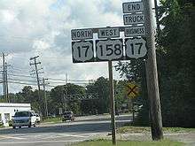
| Pasquotank | Morgans Corner | 278.1 | 447.6 | North end of US 17 overlap | ||
| | 281.0 | 452.2 | 264 | |||
| Elizabeth City | 288.4 | 464.1 | ||||
| 289.3 | 465.6 | South end of US 17 overlap | ||||
| 289.9 | 466.5 | |||||
| Camden | Camden | 293.7 | 472.7 | |||
| Belcross | 295.6 | 475.7 | Southern terminus of NC 34 | |||
| Currituck | Barco | 306.2 | 492.8 | |||
| | 315.0 | 506.9 | ||||
| Dare | Kitty Hawk | 335.2 | 539.5 | |||
| Nags Head | 350.2 | 563.6 | Whalebone Junction | |||
1.000 mi = 1.609 km; 1.000 km = 0.621 mi
| ||||||
Special routes
Winston-Salem business loop
| |
|---|---|
| Location | Winston-Salem, North Carolina |
| Existed | 1962–1970 |
U.S. Route 158 Business, was established in 1962 as a renumbering of mainline US 158 in downtown Winston-Salem. The business loop traversed on one-way streets: eastbound used Cherry Street, 4th Street, and Dunleith Street; westbound used Marshall Street and 5th Street. In 1970, it was decommissioned.[17]
Oxford alternate route
| |
|---|---|
| Location | Oxford, North Carolina |
| Length | 4.7 mi[18] (7.6 km) |
| Existed | 1954–1971 |
U.S. Route 158 Alternate (US 158A), was established in 1954 as a partial bypass of Oxford. As an alternate spur route, it did not reconnect with US 158, instead going southwest to US 15. In 1971, US 158A was eliminated when Interstate 85 was built over it.[19]
Oxford business loop
| |
|---|---|
| Location | Oxford, North Carolina |
| Length | 4.2 mi[20] (6.8 km) |
| Existed | 1994–present |
U.S. Route 158 Business, established in 1994, is a 4.2-mile (6.8 km) business loop that followed the original US 158 route through downtown Oxford, via Roxboro Road, College Street, and Williamsboro Street.[17]
The entire route is in Oxford, Granville County.
| mi[20] | km | Destinations | Notes | ||
|---|---|---|---|---|---|
| 0.0 | 0.0 | ||||
| 0.7 | 1.1 | North end of NC 96 overlap | |||
| 1.2 | 1.9 | North end of US 15 overlap | |||
| 2.0 | 3.2 | South end of US 15 and NC 96 overlap | |||
| 4.2 | 6.8 | ||||
1.000 mi = 1.609 km; 1.000 km = 0.621 mi
| |||||
Henderson alternate route
| |
|---|---|
| Location | Henderson, North Carolina |
| Length | 8.5 mi[21] (13.7 km) |
| Existed | 1951–1960 |
U.S. Route 158 Alternate (US 158A), was established in 1951, when mainline US 158 bypassed north of Henderson. US 158A followed the original route through downtown Henderson until 1960, when it was renumbered to US 158 Business.[19]
Henderson business loop
| |
|---|---|
| Location | Henderson, North Carolina |
| Length | 8.5 mi[21] (13.7 km) |
| Existed | 1960–present |
U.S. Route 158 Business, established in 1960, is a 8.5-mile (13.7 km) business loop through downtown Henderson, via Oxford Road, Danbney Drive, and Garnett Street.[17]
| County | Location | mi[21] | km | Destinations | Notes |
|---|---|---|---|---|---|
| Granville | | 0.0 | 0.0 | ||
| Vance | Henderson | 6.4 | 10.3 | South end of US 1 business overlap | |
| 8.5 | 13.7 | North end of US 1 business overlap | |||
1.000 mi = 1.609 km; 1.000 km = 0.621 mi
| |||||
Warrenton alternate route
| |
|---|---|
| Location | Warrenton, North Carolina |
| Length | 7.5 mi[22] (12.1 km) |
| Existed | 1950–1960 |
U.S. Route 158 Alternate (US 158A), was established in 1950, when mainline US 158 bypassed north of Gatesville. US 158A followed the original route through downtown Warrenton until 1960, when it was renumbered to US 158 Business.[19]
Warrenton business loop
| |
|---|---|
| Location | Warrenton, North Carolina |
| Length | 7.5 mi[22] (12.1 km) |
| Existed | 1960–present |
U.S. Route 158 Business, established in 1960, is a 7.5-mile (12.1 km) business loop through downtown Warrenton.[17]
The entire route is in Warren County.
| Location | mi[22] | km | Destinations | Notes | |
|---|---|---|---|---|---|
| Norlina | 0.0 | 0.0 | North end of US 401 overlap | ||
| Warrenton | 3.1 | 5.0 | South end of US 401 and north end of NC 58 overlap | ||
| | 3.7 | 6.0 | South end of NC 58 overlap | ||
| Macon | 7.5 | 12.1 | |||
1.000 mi = 1.609 km; 1.000 km = 0.621 mi
| |||||
Murfreesboro business loop
| |
|---|---|
| Location | Murfreesboro, North Carolina |
| Length | 4.4 mi[23] (7.1 km) |
| Existed | 1996–present |
U.S. Route 158 Business, established in 1996, is a 4.4-mile (7.1 km) business loop that followed the original US 158 route through downtown Murfreesboro, via Main Street.[17]
| County | Location | mi[23] | km | Destinations | Notes |
|---|---|---|---|---|---|
| Northampton | | 0.0 | 0.0 | ||
| Hertford | Murfreesboro | 2.8 | 4.5 | ||
| | 4.4 | 7.1 | |||
| 1.000 mi = 1.609 km; 1.000 km = 0.621 mi | |||||
Gatesville alternate route
| |
|---|---|
| Location | Gatesville, North Carolina |
| Length | 4.9 mi[24] (7.9 km) |
| Existed | 1948–1960 |
U.S. Route 158 Alternate (US 158A), was established in 1948, two years after mainline US 158 bypassed north of Gatesville. It followed the original route through downtown Gatesville. In 1960, it was renumbered to US 158 Business.[19]
Gatesville business loop
| |
|---|---|
| Location | Gatesville, North Carolina |
| Length | 4.9 mi[24] (7.9 km) |
| Existed | 1960–present |
U.S. Route 158 Business, established in 1960, is a 4.9-mile (7.9 km) business loop through downtown Gatesville.[17]
The entire route is in Gates County.
| Location | mi[24] | km | Destinations | Notes | |
|---|---|---|---|---|---|
| | 0.0 | 0.0 | |||
| | 1.3 | 2.1 | North end of NC 37 overlap | ||
| Gatesville | 2.5 | 4.0 | South end of NC 37 overlap | ||
| | 4.9 | 7.9 | |||
1.000 mi = 1.609 km; 1.000 km = 0.621 mi
| |||||
Kill Devil Hills business loop
| |
|---|---|
| Location | Kill Devil Hills, North Carolina |
| Length | 15.2 mi[25] (24.5 km) |
| Existed | 1960–1988 |
U.S. Route 158 Business, was established in 1960 as a renumbering of mainline US 158 on Bodie Island. In 1988, US 158 Business was decommissioned, replaced by a northern extension of NC 12.[17]
See also
References
- 1 2 Google (2011-02-13). "US 158" (Map). Google Maps. Google. Retrieved 2011-02-13.
- ↑ North Carolina Primary Highway System (PDF) (Map). Cartography by NCDOT. North Carolina Department of Transportation. 1940. Retrieved July 15, 2014.
- ↑ North Carolina Primary Highway System (PDF) (Map). Cartography by NCDOT. North Carolina Department of Transportation. 1951. Retrieved July 15, 2014.
- ↑ North Carolina County Maps (PDF) (Map). North Carolina Department of Transportation. 1957. Retrieved July 15, 2014.
- ↑ North Carolina Primary Highway System (PDF) (Map). Cartography by NCDOT. North Carolina Department of Transportation. 1960. Retrieved July 15, 2014.
- ↑ North Carolina County Maps (PDF) (Map). North Carolina Department of Transportation. 1968. Retrieved July 15, 2014.
- ↑ "Route Change (1968-12-06)" (PDF). North Carolina Department of Transportation. December 6, 1968. Retrieved July 15, 2014.
- ↑ "Route Change (1971-09-02)" (PDF). North Carolina Department of Transportation. September 2, 1971. Retrieved July 15, 2014.
- ↑ "Route Change (1973-05-02)" (PDF). North Carolina Department of Transportation. May 2, 1973. Retrieved July 15, 2014.
- ↑ "Route Change (1979-07-01)" (PDF). North Carolina Department of Transportation. July 1, 1979. Retrieved July 15, 2014.
- ↑ "Route Change (1984-11-01)" (PDF). North Carolina Department of Transportation. November 1, 1984. Retrieved July 15, 2014.
- ↑ "Route Change (1995-03-20)" (PDF). North Carolina Department of Transportation. March 20, 1995. Retrieved July 15, 2014.
- ↑ "Route Change (2008-04-05)" (PDF). North Carolina Department of Transportation. April 5, 2018. Retrieved June 4, 2018.
- ↑ "NCRoads.com: U.S. 117". Retrieved July 14, 2013.
- ↑ Virginia Highways Page: US 117
- ↑ Staff. "Winston-Salem Northern Beltway". North Carolina Department of Transportation. Retrieved June 4, 2018.
- 1 2 3 4 5 6 7 "NCRoads.com: U.S. 158-B". Retrieved January 24, 2013.
- ↑ Google (January 24, 2013). "US 158 Alt - Oxford" (Map). Google Maps. Google. Retrieved January 24, 2013.
- 1 2 3 4 "NCRoads.com: U.S. 158-A". Retrieved January 24, 2013.
- 1 2 Google (February 13, 2011). "US 158 Bus - Oxford" (Map). Google Maps. Google. Retrieved February 13, 2011.
- 1 2 3 Google (January 24, 2013). "US 158 Bus - Henderson" (Map). Google Maps. Google. Retrieved January 24, 2013.
- 1 2 3 Google (February 13, 2011). "US 158 Bus - Warrenton" (Map). Google Maps. Google. Retrieved February 13, 2011.
- 1 2 Google (February 13, 2011). "US 158 Bus - Murfreesboro" (Map). Google Maps. Google. Retrieved February 13, 2011.
- 1 2 3 Google (February 13, 2011). "US 158 Bus - Gatesville" (Map). Google Maps. Google. Retrieved February 13, 2011.
- ↑ Google (January 24, 2013). "US 158 Bus - Kill Devil Hills" (Map). Google Maps. Google. Retrieved January 24, 2013.
External links

- NCRoads.com: U.S. Route 158
- NCRoads.com: U.S. Route 158-A
- NCRoads.com: U.S. Route 158 Business
- Virginia Highway Index: U.S. Route 158
- Endpoints of US Highway 158