Frisco, North Carolina
| Frisco, North Carolina | |
|---|---|
| Census-designated place | |
 Frisco Native American Museum | |
 Location in Dare County and the state of North Carolina | |
| Coordinates: 35°13′47″N 75°37′56″W / 35.22972°N 75.63222°WCoordinates: 35°13′47″N 75°37′56″W / 35.22972°N 75.63222°W | |
| Country | United States of America |
| State | North Carolina |
| County | Dare |
| Area | |
| • Total | 0.78 sq mi (2.01 km2) |
| • Land | 0.75 sq mi (1.95 km2) |
| • Water | 0.03 sq mi (0.07 km2) |
| Elevation | 3 ft (0.9 m) |
| Population (2010) | |
| • Total | 200 |
| • Density | 266/sq mi (102.7/km2) |
| ZIP code | 27936 |
Frisco is a small unincorporated community and census-designated place (CDP) on the barrier island of Hatteras Island, between the villages of Buxton and Hatteras. It is located in Dare County, North Carolina, United States, and was previously named "Trent", or "Trent Woods", but received a new name with the coming of the post office in 1898. Most of the land is taken by houses available for rental during the summer months, and as such the community's population varies seasonally. As of the 2010 census, the permanent population of the community was 200.[1] North Carolina Highway 12 serves as the primary road in Frisco and connects the community to others on the island.
Billy Mitchell Airport is located in Frisco and was named after former Army General Billy Mitchell. Across the street from the small, local airfield is the Frisco Native American Museum.[2]
The residents of Frisco are governed by the Dare County Board of Commissioners. Frisco is part of District 4, along with Avon, Buxton, Hatteras, Rodanthe, Waves and Salvo.
Public services
Residents of Frisco are served by the Cape Hatteras Elementary and Secondary Schools located on NC 12 in Frisco.[3]
Area attractions
- Cape Hatteras National Seashore
- Frisco Campground
- Frisco Pier (Destroyed by Hurricane Earl, 2010)
- Billy Mitchell Airport
- Frisco Native American Museum
- Frisco Mini-Golf and Go Karts
- Red Drum Pottery Gallery and Theater
 Billy Mitchell Airport, June 2007
 Sunset at Frisco, June 2008
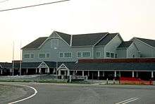 Construction of the new Cape Hatteras Elementary and Secondary School, June 2007
References
- ↑ "Geographic Identifiers: 2010 Demographic Profile Data (G001): Frisco CDP, North Carolina". U.S. Census Bureau, American Factfinder. Retrieved November 24, 2015.
- ↑ Frisco Native American Museum
- ↑ District Website Archived 2007-06-30 at the Wayback Machine.
External links
| Preceded by Cape Hatteras |
Beaches of The Outer Banks | Succeeded by Hatteras |
Municipalities and communities of Dare County, North Carolina, United States | ||
|---|---|---|
| Towns | 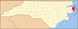 | |
| CDPs | ||
| Unincorporated communities | ||