Core Banks, North Carolina
 | |
 Core Banks | |
| Geography | |
|---|---|
| Location | Southern Outer Banks, Carteret County, North Carolina, United States |
| Coordinates | 34°42′23″N 76°27′32″W / 34.70639°N 76.45889°W |
| Administration | |
|
United States | |
| Nearest city | Harkers Island, NC |
| Governing body | National Park Service |
| Demographics | |
| Population | no permanent population |
| Pop. density | 0 /km2 (0 /sq mi) |
The Core Banks are barrier islands in North Carolina, part of the Outer Banks and Cape Lookout National Seashore. Named after the Coree tribe, they extend from Ocracoke Inlet to Cape Lookout, and consist of two low-relief narrow islands, North Core Banks and South Core Banks, and, since September 2011, two smaller islands. New Drum Inlet, Old Drum Inlet and Ophelia Inlet now separate the islands. The Core Banks are now uninhabited. However, Portsmouth, at the north end of the North Core Banks, was once a substantial port, and Cape Lookout Village, about one and half miles south of the Cape Lookout Lighthouse, contains the historic Lookout Life-Saving Station, a U.S. Coast Guard Station, and several island homes.
Access
Islands can be reached by two vehicle ferries. One ferry crosses Core Sound from Atlantic to North Core Banks, and another crosses the sound from Davis to South Core Banks. There are no roads on the islands: vehicles use the beach and four wheel drive tracks. Passenger ferries also take tourists from Harkers Island to the Cape Lookout area at the south end of South Core Banks.[1]
Portsmouth Island, on which Portsmouth Village stands, is a tidal island accessible from North Core Banks at most states of the tide.
History
The Cape Lookout Coast Guard Station, Cape Lookout Light Station, and Cape Lookout Village Historic District are listed on the National Register of Historic Places.[2]
Geography

The geography of the Core Banks has changed since the mid 19th century. At that time South Core Banks was connected to the Shackleford Banks. Over the years inlets have closed and opened in the barrier islands. From north to south these inlets have been Whalebone Inlet, now closed, which separated Portsmouth Island from the Core Banks, Swash Inlet (closed), Old Drum Inlet (closed in 1971 and reopened by Hurricane Irene in 2011), New Drum Inlet (opened by the U.S. Army Corps of Engineers in 1971), Ophelia Inlet (opened by Hurricane Ophelia in 2005[3]), Cedar Inlet (closed) and Barden Inlet (opened by a hurricane in 1933, separating Shackleford Banks from South Core Banks).[4]
From northeast to southwest, the islands are located in the Townships of Portsmouth, Atlantic, Sea Level, Stacy, Davis, Smyrna, and Harkers Island, all in Carteret County.
Gallery
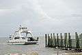 Access by ferry
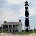 Cape Lookout Lighthouse and Keeper's Quarters.
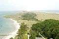 View from Cape Lookout Lighthouse looking North East
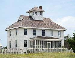
 Portsmouth church
 Bodyboarding near Great Island cabins
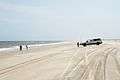 Surf fishing
 Recreational vehicle customized for beach driving and surf fishing.
 In 1976, about 1,500 vehicles were removed from the island.[5] Few remain.
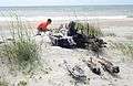 Many shipwreck remains can be found on the beaches[6]
 Confusing wave patterns at the beach at Cape Lookout point. Waves are coming from several directions.
 Fires are allowed on the beach
References
- ↑ Cape Lookout National Seashore: Ferry Services
- ↑ National Park Service (2010-07-09). "National Register Information System". National Register of Historic Places. National Park Service.
- ↑ David J. Mallinson; et al. (2008). "Past,Present and Future Inlets of the Outer Banks Barrier Islands, North Carolina" (PDF). page 12
- ↑ Barrier Island Ecology of Cape Lookout National Seashore, NPS Scientific Monograph No.9, Chapter 3
- ↑ The Dispatch; Jun 25, 1976
- ↑ Surface Interval Diving Company (SIDCO). "The 2002 and 2005 Core Banks Beach Wreck Survey(s)". Retrieved 2 August 2013.
| Preceded by Portsmouth Island |
Beaches of The Outer Banks | Succeeded by Cape Lookout |
Coordinates: 34°42′23″N 76°27′32″W / 34.70639°N 76.45889°W