North Carolina Highway 157
| ||||
|---|---|---|---|---|
 | ||||
| Route information | ||||
| Maintained by NCDOT | ||||
| Length | 29.3 mi[1] (47.2 km) | |||
| Major junctions | ||||
| South end |
| |||
|
| ||||
| North end |
| |||
| Location | ||||
| Counties | Durham, Orange, Person | |||
| Highway system | ||||
| ||||

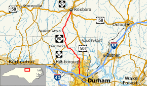
North Carolina Highway 157 (NC 157) is a north–south highway that travels from Interstate 85 (I-85), U.S. Routes 15 (US 15), US 70, and US 501 in Durham, to US 158/US 501 and NC 57 in Roxboro. It is called Guess Road, while it is in Durham.
Major intersections
| County | Location | mi[1] | km | Destinations | Notes |
|---|---|---|---|---|---|
| Durham | Durham | 0.0– 0.1 | 0.0– 0.16 | Exit 175 (I-85) | |
| Orange | Caldwell | 14.2 | 22.9 | ||
| Person | Roxboro | 29.3 | 47.2 | ||
| 1.000 mi = 1.609 km; 1.000 km = 0.621 mi | |||||
References
Route map:
- 1 2 Google (April 14, 2016). "North Carolina Highway 157" (Map). Google Maps. Google. Retrieved April 14, 2016.
This article is issued from
Wikipedia.
The text is licensed under Creative Commons - Attribution - Sharealike.
Additional terms may apply for the media files.