Buxton, North Carolina
| Buxton, North Carolina | |
|---|---|
| Census-designated place | |
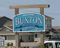 Welcome sign | |
 Location in Dare County and the state of North Carolina. | |
 Buxton Location in North Carolina and the United States  Buxton Buxton (the US) | |
| Coordinates: 35°16′4″N 75°32′33″W / 35.26778°N 75.54250°WCoordinates: 35°16′4″N 75°32′33″W / 35.26778°N 75.54250°W | |
| Country | United States of America |
| State | North Carolina |
| County | Dare |
| Area | |
| • Total | 2.98 sq mi (7.73 km2) |
| • Land | 2.96 sq mi (7.67 km2) |
| • Water | 0.02 sq mi (0.06 km2) |
| Elevation | 11 ft (3 m) |
| Population (2010) | |
| • Total | 1,273 |
| • Density | 430/sq mi (166.0/km2) |
| ZIP code | 27920 |
Buxton is an unincorporated community and census-designated place (CDP) on Hatteras Island (part of the Outer Banks) near Cape Hatteras. It is located in Dare County in the U.S. state of North Carolina. As of the 2010 census it had a population of 1,273.[1] Located at the widest part of Hatteras Island, it is the largest community on Hatteras Island both in terms of area and population, and is home to the islands schools and other major public buildings and offices.
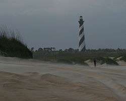
North Carolina Highway 12 links the community to other Outer Banks communities such as Avon, Frisco, and Hatteras. Buxton is most famous for being the location of Cape Hatteras Light; it is also the home of the Cape Hatteras Anglers Club.
The residents of Buxton are governed by the Dare County Board of Commissioners. Buxton is part of District 4, along with Avon, Frisco, Hatteras, Rodanthe, Waves and Salvo.
In addition to Cape Hatteras Light, the SS Lancing shipwreck was listed on the National Register of Historic Places in 2013.[2]
Recreation
Watersports are common on both the Pamlico Sound side and the Atlantic Ocean side of the community. Proximity to the convergence of the Labrador Current and the Gulf Stream result in the largest surf available on the East Coast. On the protected soundside of the island, watersports such as windsurfing, kayaking, kiteboarding, and swimming are all readily available and accessible.
Education
Residents are served by the new Cape Hatteras Elementary School, opened in 2001 (home of the Tropical Storms) and Cape Hatteras Secondary School of Coastal Studies, a combination middle school and high school (Home of the Hurricanes) newly rebuilt in 2007 on the NC 12 site of the original Cape Hatteras Elementary and Cape Hatteras Secondary Schools, in Buxton.[3] Both schools are part of the Dare County Schools district.[4]
British Cemetery
On May 21, 1942, the body of a British seaman, unidentifiable but presumed to be from the HMT Bedfordshire, sunk by a German U-boat, washed ashore. The month prior, a British sailor from the sunken merchant ship San Delfino had been buried in Buxton. The Bedfordshire seaman was interred in an adjacent plot, resulting in a British Cemetery, formally known as Cape Hatteras Coast Guard Burial Ground.[5]
References
- ↑ "Geographic Identifiers: 2010 Demographic Profile Data (G001): Buxton CDP, North Carolina". U.S. Census Bureau, American Factfinder. Retrieved November 24, 2015.
- ↑ "National Register of Historic Places Listings". Weekly List of Actions Taken on Properties: 6/24/13 through 6/28/13. National Park Service. 2013-07-05.
- ↑ Davis, Kristin (August 26, 2007). "Cape Hatteras Secondary goes back to school in style". The Virginian-Pilot. Retrieved July 1, 2017.
- ↑ "Attendance Areas - Dare County Schools". www.dare.k12.nc.us. Retrieved 2015-12-17.
- ↑ "Cape Hatteras (U.S. Coast Guard) Burial Ground". Commonwealth War Graves Commission. Retrieved 25 October 2012.
| Preceded by Avon |
Beaches of The Outer Banks | Succeeded by Cape Hatteras |
Municipalities and communities of Dare County, North Carolina, United States | ||
|---|---|---|
| Towns | 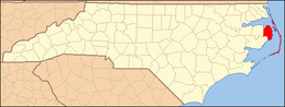 | |
| CDPs | ||
| Unincorporated communities | ||