Waves, North Carolina
| Waves, North Carolina | |
|---|---|
| Census-designated place | |
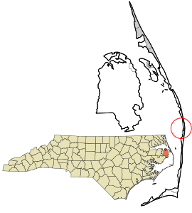 Location in Dare County and the state of North Carolina | |
| Coordinates: 35°34′0″N 75°28′6″W / 35.56667°N 75.46833°WCoordinates: 35°34′0″N 75°28′6″W / 35.56667°N 75.46833°W | |
| Country | United States |
| State | North Carolina |
| County | Dare |
| Area | |
| • Total | 0.55 sq mi (1.43 km2) |
| • Land | 0.55 sq mi (1.43 km2) |
| • Water | 0.0 sq mi (0.0 km2) |
| Elevation | 5 ft (2 m) |
| Population (2010) | |
| • Total | 134 |
| • Density | 243/sq mi (93.8/km2) |
| Time zone | UTC-5 (Eastern (EST)) |
| • Summer (DST) | UTC-4 (EST) |
| ZIP code | 27982 |
| FIPS code | 37-71440 |
| GNIS feature ID | 1023135[1] |
Waves is an unincorporated community and census-designated place (CDP) in Dare County, North Carolina, United States. It is on Hatteras Island, part of North Carolina's Outer Banks. As of the 2010 census it had a population of 134.[2] Waves, along with Rodanthe and Salvo, are part of the settlement of Chicamacomico.
The residents of Waves are governed by the Dare County Board of Commissioners. Waves is part of District 4, along with Avon, Buxton, Frisco, Hatteras, Rodanthe and Salvo.
History
The community was so named on account of waves at the beach.[3]
The Rasmus Midgett House was listed on the National Register of Historic Places in 2009.[4]
Boundaries
The northern border of Waves is generally considered to be the ditch that runs under Highway 12 just south of Resort Rodanthe Drive. The southern border, separating Waves and Salvo, is more ambiguous. Long-time residents indicate various "official lines" separating the two. Formerly Rodanthe, Waves and Salvo were each served by their own post office. Today a single post office, located in Waves, serves the entire community and the former lines that separated the communities have become blurred.

Economy
The Waves area is dominated by campgrounds both large and small as well as numerous rental houses.
References
- ↑ U.S. Geological Survey Geographic Names Information System: Waves, North Carolina
- ↑ "Geographic Identifiers: 2010 Demographic Profile Data (G001): Waves CDP, North Carolina". U.S. Census Bureau, American Factfinder. Retrieved November 24, 2015.
- ↑ Moyer, Armond; Moyer, Winifred (1958). The origins of unusual place-names. Keystone Pub. Associates. p. 137.
- ↑ National Park Service (2010-07-09). "National Register Information System". National Register of Historic Places. National Park Service.
| Preceded by Rodanthe |
Beaches of The Outer Banks | Succeeded by Salvo |
Municipalities and communities of Dare County, North Carolina, United States | ||
|---|---|---|
| Towns | 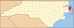 | |
| CDPs | ||
| Unincorporated communities | ||