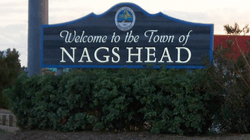
Nags Head, North Carolina
| Nags Head, North Carolina | |
|---|---|
| Town | |
 | |
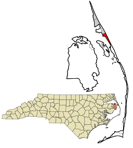 Location in Dare County and the state of North Carolina. | |
| Coordinates: 35°55′55″N 75°36′54″W / 35.93194°N 75.61500°WCoordinates: 35°55′55″N 75°36′54″W / 35.93194°N 75.61500°W | |
| Country | United States |
| State | North Carolina |
| County | Dare |
| Area | |
| • Total | 6.6 sq mi (17.2 km2) |
| • Land | 6.6 sq mi (17.0 km2) |
| • Water | 0.08 sq mi (0.2 km2) |
| Elevation | 3 ft (1 m) |
| Population (2010) | |
| • Total | 2,757 |
| • Estimate (2016)[1] | 2,916 |
| • Density | 420/sq mi (160/km2) |
| Time zone | UTC-5 (Eastern (EST)) |
| • Summer (DST) | UTC-4 (EDT) |
| ZIP code | 27959 |
| Area code(s) | 252 |
| FIPS code | 37-45880[2] |
| GNIS feature ID | 1021599[3] |
| Website |
townofnagshead |
Nags Head is a town in Dare County, North Carolina, United States. It is a busy vacation spot because of its beaches and sand dunes of Jockey's Ridge. The population was 2,757 at the 2010 census.[4]
History
Early maps of the area show Nags Head as a promontory of land characterized by high sand dunes visible from miles at sea. The origin of the town's name is obscure, but it is likely to have been named after any one of the Nag's Heads on the English coast.[5]
A folkloric explanation claims that mules or horses (nags) would have lights hung on their heads by nefarious wreckers in order to trick ships into running aground and then loot the ships of their valuables.[6] The town's emblem depicts one such equine accomplice from the tale.[7]
Around 1830,[8] Nags Head became known as a resort area, and so remains today. Jockey's Ridge is the last vestige of the sand dunes seen by the first explorers, as the area is now highly developed. The town incorporated in 1961.[9]
Geography
Nags Head is located at 35°55′55″N 75°36′54″W / 35.93194°N 75.61500°W (35.932004, -75.615085).[10]
According to the United States Census Bureau, the town has a total area of 6.6 square miles (17.2 km2), of which 6.6 square miles (17.0 km2) is land and 0.1 square miles (0.2 km2), or 1.15%, is water.[4]
Demographics
| Historical population | |||
|---|---|---|---|
| Census | Pop. | %± | |
| 1970 | 414 | — | |
| 1980 | 1,020 | 146.4% | |
| 1990 | 1,838 | 80.2% | |
| 2000 | 2,700 | 46.9% | |
| 2010 | 2,757 | 2.1% | |
| Est. 2016 | 2,916 | [1] | 5.8% |
| sources:[11] | |||
As of the census[2] of 2010, there were 2,757 people, 1,223 households, and 741 families residing in the town. The population density was 413.2 people per square mile (159.4/km²). There were 4,884 housing units at an average density of 634.9 per square mile (244.9/km²). The racial makeup of the town was 94.6% White, 1.6% African American, 0.15% Native American, 0.3% Asian, 1.4% from other races, and 1.5% from two or more races. Hispanic or Latino of any race were 1.44% of the population.
There were 1,223 households out of which 23.1% had children under the age of 18 living with them, 49.2% were married couples living together, 7.2% had a female householder with no husband present, and 39.4% were non-families. 29.0% of all households were made up of individuals and 8.8% had someone living alone who was 65 years of age or older. The average household size was 2.19 and the average family size was 2.65.
In the town, the population was spread out with 19.2% under the age of 18, 5.1% from 18 to 24, 30.7% from 25 to 44, 28.0% from 45 to 64, and 17.0% who were 65 years of age or older. The median age was 43 years. For every 100 females, there were 98.1 males. For every 100 females age 18 and over, there were 99.4 males.
The median income for a household in the town was $53,095, and the median income for a family was $61,302. Males had a median income of $33,289 versus $30,139 for females. The per capita income for the town was $30,157. About 4.4% of families and 6.1% of the population were below the poverty line, including 7.9% of those under age 18 and 4.3% of those age 65 or over.
Attractions
Located in Nags Head is the largest sand dune on the East Coast, Jockey's Ridge. The sand dune has migrated over the years from the energy of coastal winds and has buried a miniature golf course along the way. Jockey's Ridge has been popular with hang-gliders since the advent of the sport, as well as kite flyers. The park's visitor center includes an informative museum with exhibits on sand, weather, and local fauna. The diversity of wildlife may change with seasonal migrations and includes bird species, foxes, mice, squirrels, occasional deer and rabbits.
One of the most exciting features of the Ridge is its capriciousness. Annual visitors find that ephemeral pools can spring up, and the sand can shift, making for a fresh experience every time. From the top of the Ridge, the ocean as well as the sound can be seen. Jockey's Ridge has a sound beach on the Roanoke Sound side that visitors can swim in.
The Nags Head Woods Ecological Preserve is 1,092 acres (4.42 km2) and lies North of Jockey's Ridge and east of Roanoke Sound. It was designated a National Natural Landmark in 1974.[12]
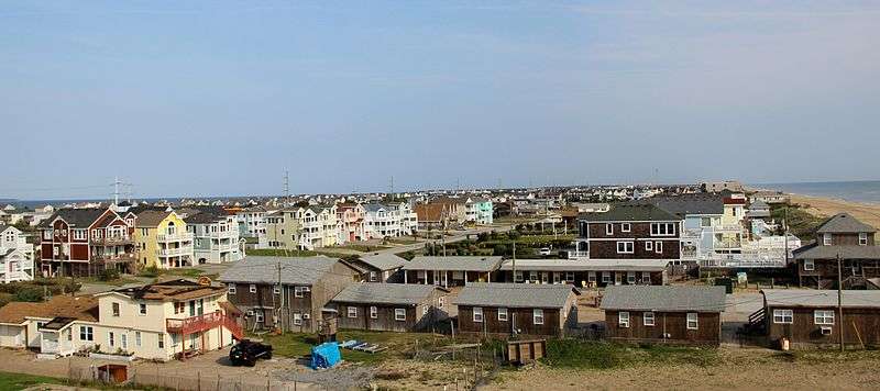
As in any other beach town, the ocean and shoreline are the major attractions, providing beaches for swimming, sunbathing, and a variety of water sports. A series of historic cottages overlook the beach in sections. There are three piers popular for fishing: Nags Head Pier, Jennette's Pier (destroyed by Hurricane Isabel in 2003, bought and renovated by the North Carolina Aquariums, reopened in May 2011), and Outer Banks Pier. The town also features miniature golf courses and small amusement centers with go-karts and bumper cars for family entertainment.
Other attractions include various National Register of Historic Places in or near Nags Head, such as the following:
| Landmark name[13] | Image | Date listed | Location | Notes |
|---|---|---|---|---|
| Bodie Island Lifesaving and Coast Guard Station | .jpg) |
February 9, 1979 | S of Nags Head on NC 12 35°50′11″N 75°33′33″W / 35.83639°N 75.55917°W |
|
| Bodie Island Light Station | 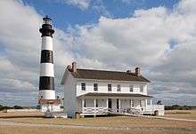 |
July 4, 2003 | Off NC 12 35°49′12″N 75°33′49″W / 35.82000°N 75.56361°W |
|
| First Colony Inn | 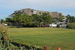 |
January 21, 1993 | 6720 S. Virginia Dare Trail 35°55′6″N 75°36′13″W / 35.91833°N 75.60361°W |
|
| Markham-Albertson-Stinson Cottage | January 13, 2006 | 4300 W. Soundside Rd. 35°56′45.51″N 75°37′45.93″W / 35.9459750°N 75.6294250°W |
Destroyed by Hurricane Irene[14] | |
| Mattie Midgett Store and House | December 23, 2004 | 4008 S. Virginia Dare Trail 35°57′23″N 75°37′28″W / 35.95639°N 75.62444°W |
||
| Nags Head Beach Cottages Historic District | August 19, 1977 | U.S. 158 35°57′50″N 75°35′49″W / 35.96389°N 75.59694°W |
||
| Sea Foam Motel |  |
December 23, 2004 | 7111 S. Virginia Dare Trail 35°54′37″N 75°35′47″W / 35.91028°N 75.59639°W |
|
| USS Huron (1875) | November 15, 1991 | Address restricted | wrecked in the area, 1877 |
References
- 1 2 "Population and Housing Unit Estimates". Retrieved June 9, 2017.
- 1 2 "American FactFinder". United States Census Bureau. Retrieved 2008-01-31.
- ↑ "US Board on Geographic Names". United States Geological Survey. 2007-10-25. Retrieved 2008-01-31.
- 1 2 "Geographic Identifiers: 2010 Demographic Profile Data (G001): Nags Head town, North Carolina". U.S. Census Bureau, American Factfinder. Retrieved November 20, 2015.
- ↑ "The Beginning of New Hope Church, Nags Head Chapel" (PDF). Northern Hills United Methodist Church.
- ↑ Renouf, Norman; Renouf, Kathy (1999). The Carolinas & the Georgia Coast. Hunter Publishing, Inc. p. 229. ISBN 978-1-55650-854-7.
Legend has it that "wrecking" was a popular pastime and source of income for the early inhabitants. It seems that certain ne'r-do-wells would tie lanterns to their horses' necks [...]
- ↑ "Town Brochure".
- ↑ "Nags Head Guide". 2011. Retrieved 2012-10-14.
- ↑ "Nags Head". Outer Banks of North Carolina. Retrieved April 5, 2013.
- ↑ "US Gazetteer files: 2010, 2000, and 1990". United States Census Bureau. 2011-02-12. Retrieved 2011-04-23.
- ↑ "Census of Population and Housing". U.S. Census Bureau. Retrieved April 5, 2013.
- ↑ "NPS: Explore Nature » National Natural Landmarks". National Park Service. 2009-06-25. Retrieved 2009-10-04.
- ↑ National Park Service (2008-04-24). "National Register Information System". National Register of Historic Places. National Park Service.
- ↑ https://www.theatlantic.com/infocus/2011/08/hurricane-irene/100138/
External links
| Wikivoyage has a travel guide for Nags Head. |
- Official website
- Webcams: Nags Head - East and Nags Head - West from outerbanks.net
Municipalities and communities of Dare County, North Carolina, United States | ||
|---|---|---|
| Towns | 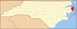 | |
| CDPs | ||
| Unincorporated communities | ||