Tippecanoe Township, Tippecanoe County, Indiana
| Tippecanoe Township | |
|---|---|
| Township | |
 The view from Prophet's Rock near Battle Ground | |
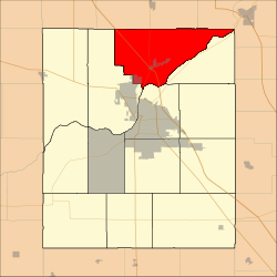 Location in Tippecanoe County | |
| Coordinates: 40°31′33″N 86°50′55″W / 40.52583°N 86.84861°WCoordinates: 40°31′33″N 86°50′55″W / 40.52583°N 86.84861°W | |
| Country | United States |
| State | Indiana |
| County | Tippecanoe |
| Government | |
| • Type | Indiana township |
| Area | |
| • Total | 48.81 sq mi (126.4 km2) |
| • Land | 48 sq mi (120 km2) |
| • Water | 0.81 sq mi (2.1 km2) 1.66% |
| Elevation[1] | 659 ft (201 m) |
| Population (2010) | |
| • Total | 7,702 |
| • Density | 160.5/sq mi (62.0/km2) |
| Time zone | UTC-5 (Eastern (EST)) |
| • Summer (DST) | UTC-4 (EDT) |
| ZIP codes | 47906, 47920 |
| Area code(s) | 765 |
| GNIS feature ID | 453898 |
Tippecanoe Township is one of thirteen townships in Tippecanoe County, Indiana, United States. As of the 2010 census, its population was 7,702 and it contained 3,085 housing units.[2]
History
Archeological Sites 12T59 and 12T530, Cairo Skywatch Tower, and Indiana State Soldiers Home Historic District are listed on the National Register of Historic Places.[3][4]
Geography
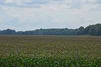
Fields east of Prophetstown State Park
According to the 2010 census, the township has a total area of 48.81 square miles (126.4 km2), of which 48 square miles (120 km2) (or 98.34%) is land and 0.81 square miles (2.1 km2) (or 1.66%) is water.[2]
Cities and towns
- Battle Ground
- West Lafayette (northeast edge)
Unincorporated towns
- Ash Grove at 40°32′52″N 86°50′52″W / 40.5478136°N 86.8477882°W
- Cairo at 40°32′27″N 86°55′29″W / 40.5408685°N 86.9247344°W
(This list is based on USGS data and may include former settlements.)
Extinct towns
Adjacent townships
- Prairie Township, White County (north)
- Deer Creek Township, Carroll County (east)
- Washington Township (east)
- Fairfield Township (south)
- Wabash Township (southwest)
Cemeteries
The township contains these six cemeteries: Battle Ground, Cairo, Harvey, Pierce, Pretty Prairie and Swisher-Hurtz.
Major highways
Airports and landing strips
- Oahnke Airport
Rivers
School districts
- Tippecanoe School Corporation
Political districts
- Indiana's 4th congressional district
- State House District 26
- State House District 41
- State Senate District 07
- After the 2011 redistricting by the Indiana Legislature, Tippecanoe Township will no longer include State House Districts 26 & 41 but instead will be included in State House District 25. http://www.in.gov/legislative/house_republicans/rd/pdfs/House.pdf
References
- United States Census Bureau 2007 TIGER/Line Shapefiles
- United States Board on Geographic Names (GNIS)
- United States National Atlas
- ↑ "US Board on Geographic Names". United States Geological Survey. October 25, 2007. Retrieved 2017-05-09.
- 1 2 "Population, Housing Units, Area, and Density: 2010 - County -- County Subdivision and Place -- 2010 Census Summary File 1". United States Census. Retrieved 2013-05-10.
- ↑ National Park Service (2010-07-09). "National Register Information System". National Register of Historic Places. National Park Service.
- ↑ "National Register of Historic Places Listings". Weekly List of Actions Taken on Properties: 9/14/15 through 9/18/15. National Park Service. 2015-09-25.
External links
Municipalities and communities of Tippecanoe County, Indiana, United States | ||
|---|---|---|
| Cities | ||
| Towns | ||
| Townships | ||
| CDPs | ||
| Other unincorporated communities |
| |
| Ghost towns | ||
| Footnotes | ‡This populated place also has portions in an adjacent county or counties | |
This article is issued from
Wikipedia.
The text is licensed under Creative Commons - Attribution - Sharealike.
Additional terms may apply for the media files.