Bedford County, Tennessee
| Bedford County, Tennessee | |
|---|---|
 Bedford County courthouse in Shelbyville | |
|
Location in the U.S. state of Tennessee | |
 Tennessee's location in the U.S. | |
| Founded | December 7, 1807[1] |
| Named for | Thomas Bedford, early settler[2] |
| Seat | Shelbyville |
| Largest city | Shelbyville |
| Area | |
| • Total | 475 sq mi (1,230 km2) |
| • Land | 474 sq mi (1,228 km2) |
| • Water | 1.2 sq mi (3 km2), 0.2% |
| Population | |
| • (2010) | 45,058 |
| • Density | 95/sq mi (37/km2) |
| Congressional district | 4th |
| Time zone | Central: UTC−6/−5 |
| Website |
www |
Bedford County is a county located in the U.S. state of Tennessee. As of the 2010 census, the population was 45,058.[3] Its county seat is Shelbyville.[4]
Bedford County comprises the Shelbyville, TN Micropolitan Statistical Area, which is also included in the Nashville-Davidson-Murfreesboro, TN Combined Statistical Area.
History
The county was created in 1807 when the citizens of Rutherford County living south of the Duck River and the Stones River successfully petitioned the governor to split Rutherford County in two. The new county was named after American Revolutionary War officer and large landowner in the area, Thomas Bedford.
Once the state's largest and most populous county, Bedford County's size (in terms of area) has been steadily reduced since 1809.
The county was pro-Confederate during the Civil War, but Shelbyville was mostly loyal to the Union.
Confederate general Nathan Bedford Forrest was born in 1821 in Chapel Hill (now in Marshall County) and has no connection to naming of Bedford County.
Texas pioneer William Whitaker Reed was born in Bedford County in 1816.[5]
Geography
According to the U.S. Census Bureau, the county has a total area of 475 square miles (1,230 km2), of which 474 square miles (1,230 km2) is land and 1.2 square miles (3.1 km2) (0.2%) is water.[6]
Adjacent counties
- Rutherford County (north)
- Coffee County (east)
- Moore County (southeast)
- Lincoln County (south)
- Marshall County (west)
State protected areas
- Normandy Wildlife Management Area (part)
Demographics
| Historical population | |||
|---|---|---|---|
| Census | Pop. | %± | |
| 1810 | 8,242 | — | |
| 1820 | 16,012 | 94.3% | |
| 1830 | 30,396 | 89.8% | |
| 1840 | 20,546 | −32.4% | |
| 1850 | 21,511 | 4.7% | |
| 1860 | 21,584 | 0.3% | |
| 1870 | 24,333 | 12.7% | |
| 1880 | 26,025 | 7.0% | |
| 1890 | 24,739 | −4.9% | |
| 1900 | 23,845 | −3.6% | |
| 1910 | 22,667 | −4.9% | |
| 1920 | 21,737 | −4.1% | |
| 1930 | 21,077 | −3.0% | |
| 1940 | 23,151 | 9.8% | |
| 1950 | 23,627 | 2.1% | |
| 1960 | 23,150 | −2.0% | |
| 1970 | 25,039 | 8.2% | |
| 1980 | 27,916 | 11.5% | |
| 1990 | 30,411 | 8.9% | |
| 2000 | 37,586 | 23.6% | |
| 2010 | 45,058 | 19.9% | |
| Est. 2016 | 47,484 | [7] | 5.4% |
| U.S. Decennial Census[8] 1790-1960[9] 1900-1990[10] 1990-2000[11] 2010-2014[3] | |||
As of the census of 2000, there were 37,586 people, 13,905 households, and 10,345 families residing in the county. The population density was 79 people per square mile (31/km²). There were 14,990 housing units at an average density of 32 per square mile (12/km²). The racial makeup of the county was 86.84% White, 11.48% Black or African American, 0.28% Native American, 0.45% Asian, 0.05% Pacific Islander, 2.73% from other races, and 1.16% from two or more races. 7.48% of the population were Hispanic or Latino of any race.
There were 13,905 households out of which 34.00% had children under the age of 18 living with them, 57.30% were married couples living together, 11.90% had a female householder with no husband present, and 25.60% were non-families. 21.50% of all households were made up of individuals and 9.20% had someone living alone who was 65 years of age or older. The average household size was 2.67 and the average family size was 3.06.
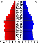
In the county, the population was spread out with 25.80% under the age of 18, 9.90% from 18 to 24, 29.70% from 25 to 44, 22.00% from 45 to 64, and 12.70% who were 65 years of age or older. The median age was 35 years. For every 100 females there were 98.40 males. For every 100 females age 18 and over, there were 97.00 males.
The median income for a household in the county was $36,729, and the median income for a family was $33,691. Males had a median income of $25,485 versus $15,673 for females. The per capita income for the county was $13,698. About 12.70% of families and 25.10% of the population were below the poverty line, including 15.90% of those under age 18 and 17.80% of those age 65 or over.
Communities
City
- Shelbyville (county seat)
Towns
Census-designated place
Unincorporated communities
- Branchville
- Center Grove
- Cortner's Station
- Fairfield
- Fall Creek
- Flat Creek
- Haley's Station
- Hawthorne
- Mount Harmond
- Palmetto
- Pleasant Grove
- Poplin's Crossroads
- Richmond
- Roseville
- Rover
Major highways
- I-24
- US-41
- US-41A
- US-231
- State Route 16
- State Route 64
- State Route 82
- State Route 130
- State Route 269
- State Route 270
- State Route 437
Politics
| Year | Republican | Democratic | Third Parties |
|---|---|---|---|
| 2016 | 74.8% 11,486 | 22.1% 3,395 | 3.1% 474 |
| 2012 | 69.5% 10,034 | 29.2% 4,211 | 1.4% 200 |
| 2008 | 65.9% 10,217 | 32.4% 5,027 | 1.7% 263 |
| 2004 | 60.9% 8,351 | 38.4% 5,268 | 0.6% 87 |
| 2000 | 48.4% 5,911 | 50.3% 6,136 | 1.3% 160 |
| 1996 | 41.1% 4,634 | 50.8% 5,735 | 8.1% 915 |
| 1992 | 33.6% 3,836 | 52.3% 5,978 | 14.1% 1,607 |
| 1988 | 54.3% 4,856 | 45.3% 4,046 | 0.4% 37 |
| 1984 | 50.6% 4,699 | 48.4% 4,499 | 1.1% 98 |
| 1980 | 35.2% 3,377 | 62.5% 5,987 | 2.3% 219 |
| 1976 | 29.2% 3,023 | 69.8% 7,228 | 1.0% 106 |
| 1972 | 59.7% 4,262 | 36.0% 2,565 | 4.3% 308 |
| 1968 | 22.3% 1,870 | 28.8% 2,416 | 48.9% 4,099 |
| 1964 | 28.8% 2,272 | 71.2% 5,610 | |
| 1960 | 36.8% 2,633 | 62.3% 4,457 | 0.9% 62 |
| 1956 | 33.1% 2,258 | 66.2% 4,517 | 0.7% 50 |
| 1952 | 37.4% 2,611 | 62.6% 4,362 | |
| 1948 | 17.9% 771 | 55.6% 2,393 | 26.4% 1,137 |
| 1944 | 21.5% 733 | 77.8% 2,651 | 0.7% 23 |
| 1940 | 18.1% 555 | 81.3% 2,499 | 0.7% 20 |
| 1936 | 17.4% 514 | 82.0% 2,428 | 0.6% 19 |
| 1932 | 21.7% 630 | 78.1% 2,264 | 0.1% 4 |
| 1928 | 47.8% 1,405 | 52.2% 1,532 | |
| 1924 | 33.2% 925 | 64.6% 1,799 | 2.2% 60 |
| 1920 | 48.5% 2,056 | 51.5% 2,182 | |
| 1916 | 33.9% 1,324 | 66.1% 2,578 | 0.0% 1 |
| 1912 | 38.0% 1,474 | 59.4% 2,305 | 2.6% 102 |
See also
References
- ↑ Timothy Marsh and Helen C. March, "Bedford County," Tennessee Encyclopedia of History and Culture. Retrieved: 31 March 2013.
- ↑ "Origins of Tennessee County Names," Tennessee Blue Book, 2009–2010, p. 533. Retrieved: 31 March 2013.
- 1 2 "State & County QuickFacts". United States Census Bureau. Retrieved November 29, 2013.
- ↑ "Find a County". National Association of Counties. Archived from the original on 2012-07-12. Retrieved 2011-06-07.
- ↑ Brochure "William Whitaker Reed House", 1850, Visitor's Center, Salado, Texas
- ↑ "2010 Census Gazetteer Files". United States Census Bureau. August 22, 2012. Retrieved April 1, 2015.
- ↑ "Population and Housing Unit Estimates". Retrieved June 9, 2017.
- ↑ "U.S. Decennial Census". United States Census Bureau. Archived from the original on May 12, 2015. Retrieved April 1, 2015.
- ↑ "Historical Census Browser". University of Virginia Library. Retrieved April 1, 2015.
- ↑ Forstall, Richard L., ed. (March 27, 1995). "Population of Counties by Decennial Census: 1900 to 1990". United States Census Bureau. Retrieved April 1, 2015.
- ↑ "Census 2000 PHC-T-4. Ranking Tables for Counties: 1990 and 2000" (PDF). United States Census Bureau. April 2, 2001. Retrieved April 1, 2015.
- ↑ Based on 2000 census data
- ↑ Leip, David. "Dave Leip's Atlas of U.S. Presidential Elections". uselectionatlas.org. Retrieved 2018-03-09.
External links


- Bedford County at Curlie (based on DMOZ)
- Bedford County, TNGenWeb - free genealogy resources for the county
- Shelbyville Mainstreet
Places adjacent to Bedford County, Tennessee | ||||||||||
|---|---|---|---|---|---|---|---|---|---|---|
| ||||||||||
Municipalities and communities of Bedford County, Tennessee, United States | ||
|---|---|---|
| City | ||
| Towns | ||
| CDP | ||
| Unincorporated communities | ||
