Seyssel, Ain
| Seyssel | ||
|---|---|---|
| Commune | ||
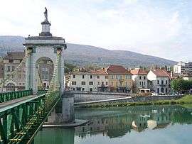 Town center seen from Seyssel, Haute-Savoie | ||
| ||
 Seyssel Location within Auvergne-Rhône-Alpes region  Seyssel | ||
| Coordinates: 45°58′00″N 5°50′00″E / 45.9667°N 5.8333°ECoordinates: 45°58′00″N 5°50′00″E / 45.9667°N 5.8333°E | ||
| Country | France | |
| Region | Auvergne-Rhône-Alpes | |
| Department | Ain | |
| Arrondissement | Belley | |
| Canton | Hauteville-Lompnes | |
| Intercommunality | Pays de Seyssel | |
| Government | ||
| • Mayor (2014–2020) | Jean-Paul Granchamp | |
| Area1 | 2.40 km2 (0.93 sq mi) | |
| Population (2014)2 | 981 | |
| • Density | 410/km2 (1,100/sq mi) | |
| Time zone | UTC+1 (CET) | |
| • Summer (DST) | UTC+2 (CEST) | |
| INSEE/Postal code | 01407 /01420 | |
| Elevation |
250–332 m (820–1,089 ft) (avg. 258 m or 846 ft) | |
|
1 French Land Register data, which excludes lakes, ponds, glaciers > 1 km2 (0.386 sq mi or 247 acres) and river estuaries. 2 Population without double counting: residents of multiple communes (e.g., students and military personnel) only counted once. | ||
.svg.png)
Seyssel is a commune in the Ain department in eastern France.
It lies on the west bank of the Rhône River.
The part of the town across the Rhône is also named Seyssel but located in the Haute-Savoie department, and is locally referred as Seyssel-Savoie. It is a rare case in France of two homonymous communes adjacent to each other, similar to the situation of the village of Saint-Santin, divided between the communes of Saint-Santin (Aveyron) and Saint-Santin-de-Maurs (Cantal).
Population
| Historical population | ||
|---|---|---|
| Year | Pop. | ±% |
| 1793 | 1,057 | — |
| 1800 | 1,058 | +0.1% |
| 1806 | 2,304 | +117.8% |
| 1821 | 1,215 | −47.3% |
| 1831 | 1,336 | +10.0% |
| 1836 | 1,230 | −7.9% |
| 1841 | 1,336 | +8.6% |
| 1846 | 1,418 | +6.1% |
| 1851 | 1,493 | +5.3% |
| 1856 | 1,312 | −12.1% |
| 1861 | 1,235 | −5.9% |
| 1866 | 1,234 | −0.1% |
| 1872 | 1,184 | −4.1% |
| 1876 | 1,150 | −2.9% |
| 1881 | 1,178 | +2.4% |
| 1886 | 1,144 | −2.9% |
| 1891 | 1,028 | −10.1% |
| 1896 | 1,032 | +0.4% |
| 1901 | 1,056 | +2.3% |
| 1906 | 989 | −6.3% |
| 1911 | 1,017 | +2.8% |
| 1921 | 924 | −9.1% |
| 1926 | 902 | −2.4% |
| 1931 | 941 | +4.3% |
| 1936 | 898 | −4.6% |
| 1946 | 1,055 | +17.5% |
| 1954 | 1,003 | −4.9% |
| 1962 | 1,001 | −0.2% |
| 1968 | 1,029 | +2.8% |
| 1975 | 1,043 | +1.4% |
| 1982 | 831 | −20.3% |
| 1990 | 817 | −1.7% |
| 1999 | 801 | −2.0% |
| 2008 | 933 | +16.5% |
| 2014 | 981 | +5.1% |
See also
- Communes of the Ain department
- Pont de la Vierge noire
- Pont de Seyssel
References
| Wikimedia Commons has media related to Seyssel, Ain. |
This article is issued from
Wikipedia.
The text is licensed under Creative Commons - Attribution - Sharealike.
Additional terms may apply for the media files.