Arandas, Ain
| Arandas | |
|---|---|
| Commune | |
 The Town Hall | |
 Arandas Location within Auvergne-Rhône-Alpes region  Arandas | |
| Coordinates: 45°53′45″N 5°29′14″E / 45.8958°N 5.4872°ECoordinates: 45°53′45″N 5°29′14″E / 45.8958°N 5.4872°E | |
| Country | France |
| Region | Auvergne-Rhône-Alpes |
| Department | Ain |
| Arrondissement | Belley |
| Canton | Ambérieu-en-Bugey |
| Intercommunality | CC Plaine Ain |
| Government | |
| • Mayor (2014-2020) | Lionel Manos |
| Area1 | 14.10 km2 (5.44 sq mi) |
| Population (2015)2 | 153 |
| • Density | 11/km2 (28/sq mi) |
| Time zone | UTC+1 (CET) |
| • Summer (DST) | UTC+2 (CEST) |
| INSEE/Postal code | 01013 /01230 |
| Elevation |
455–939 m (1,493–3,081 ft) (avg. 720 m or 2,360 ft) |
|
1 French Land Register data, which excludes lakes, ponds, glaciers > 1 km2 (0.386 sq mi or 247 acres) and river estuaries. 2 Population without double counting: residents of multiple communes (e.g., students and military personnel) only counted once. | |
Arandas is a commune in the Ain department in the Auvergne-Rhône-Alpes region of eastern France.
The inhabitants of the commune are known as Arandassiens or Arandassiennes[1]
Geography
Arandas is some 50 km north-west of Aix-les-Bains and 10 km south-west of Hauteville-Lompnes. It can be accessed by the D104 from Argis in the north running south to the village then continuing south as the D104A through the heart of the commune to join the D32 south of the commune. The D104 itself reverses direction in the village and heads north-west to join the D73. The commune has some farmland but is heavily forested and mountainous. There are no villages or hamlets in the commune other than Arandas.[2]
The Bossiere stream rises near the village and flows west to join the Galine river. The Ruisseau de Grinand also rises in the north of the commune, forming part of the northern boundary before flowing into the Galine.[2]
History
In the Middle Ages Arandas was a lordship with the most famous lord being the poet Claude Guichard in the 16th century. The commune was separated from Conand in 1865.
Administration
List of mayors of Arandas[3]
| From | To | Name | Party | Position |
|---|---|---|---|---|
| 1995 | 2002 | Pierre Ronchall | ||
| 2002 | 2008 | Gilbert Cagnin | ||
| 2008 | 2014 | Gérard Duclaux | ||
| 2014 | 2020 | Lionel Manos |
(Not all data is known)
Demography
Before 1865 the demographics of Arandas included Conand.
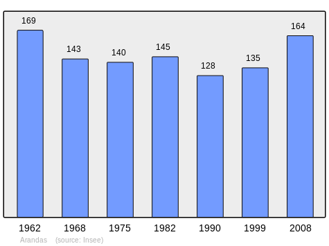
In 2010, the commune had 163 inhabitants. The evolution of the number of inhabitants is known through the population censuses conducted in the town since 1793. From the 21st century, a census of municipalities with fewer than 10,000 inhabitants is held every five years, unlike larger towns that have a sample survey every year.[Note 1]
| 1793 | 1800 | 1806 | 1821 | 1831 | 1836 | 1841 | 1846 | 1851 |
|---|---|---|---|---|---|---|---|---|
| 1,108 | 1,181 | 1,218 | 1,106 | 1,132 | 1,165 | 1,210 | 1,209 | 1,127 |
| 1856 | 1861 | 1866 | 1872 | 1876 | 1881 | 1886 | 1891 | 1896 |
|---|---|---|---|---|---|---|---|---|
| 1,144 | 1,101 | 543 | 534 | 520 | 508 | 500 | 485 | 459 |
| 1901 | 1906 | 1911 | 1921 | 1926 | 1931 | 1936 | 1946 | 1954 |
|---|---|---|---|---|---|---|---|---|
| 445 | 418 | 382 | 301 | 281 | 279 | 242 | 227 | 182 |
| 1962 | 1968 | 1975 | 1982 | 1990 | 1999 | 2006 | 2007 | 2008 |
|---|---|---|---|---|---|---|---|---|
| 169 | 143 | 140 | 145 | 128 | 135 | 155 | 158 | 164 |
| 2009 | 2010 | - | - | - | - | - | - | - |
|---|---|---|---|---|---|---|---|---|
| 165 | 163 | - | - | - | - | - | - | - |
Sources : Ldh/EHESS/Cassini until 1962, INSEE database from 1968 (population without double counting and municipal population from 2006)
Notable people linked to the commune
- Anthelme Ferrand (1758-1834), politician, member of the Convention and the Council of Five Hundred was born in the commune.
See also
External links
- Arandas on the old National Geographic Institute website (in French)
- Arandas on Lion1906
- Arandas on Google Maps
- Arandas on Géoportail, National Geographic Institute (IGN) website (in French)
- Arandas on the 1750 Cassini Map
- Arandas on the INSEE website (in French)
- INSEE (in French)
Notes and references
Notes
- ↑ At the beginning of the 21st century, the methods of identification have been modified by law No. 2002-276 of 27 February 2002 , the so-called "law of local democracy" and in particular Title V "census operations" which allow, after a transitional period running from 2004 to 2008, the annual publication of the legal population of the different French administrative districts. For municipalities with a population greater than 10,000 inhabitants, a sample survey is conducted annually, the entire territory of these municipalities is taken into account at the end of the period of five years. The first "legal population" after 1999 under this new law came into force on 1 January 2009 and was based on the census of 2006.
References
- ↑ Inhabitants of Ain (in French)
- 1 2 3 Google Maps
- ↑ List of Mayors of France (in French)
| Wikimedia Commons has media related to Arandas. |