Nivigne et Suran
| Nivigne et Suran | |
|---|---|
| Commune | |
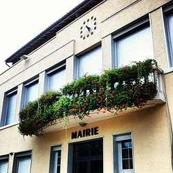 The town hall of Chavannes-sur-Suran | |
 Nivigne et Suran Location within Auvergne-Rhône-Alpes region  Nivigne et Suran | |
| Coordinates: 46°15′50″N 5°25′41″E / 46.264°N 5.428°ECoordinates: 46°15′50″N 5°25′41″E / 46.264°N 5.428°E | |
| Country | France |
| Region | Auvergne-Rhône-Alpes |
| Department | Ain |
| Arrondissement | Bourg-en-Bresse |
| Canton | Saint-Étienne-du-Bois |
| Area1 | 30.98 km2 (11.96 sq mi) |
| Population (2014)2 | 795 |
| • Density | 26/km2 (66/sq mi) |
| Time zone | UTC+1 (CET) |
| • Summer (DST) | UTC+2 (CEST) |
| INSEE/Postal code | 01095 /01250 |
|
1 French Land Register data, which excludes lakes, ponds, glaciers > 1 km2 (0.386 sq mi or 247 acres) and river estuaries. 2 Population without double counting: residents of multiple communes (e.g., students and military personnel) only counted once. | |
Nivigne et Suran is a commune in the department of Ain, eastern France. The municipality was established on 1 January 2017 by merger of the former communes of Chavannes-sur-Suran (the seat) and Germagnat.[1]
See also
References
| Wikimedia Commons has media related to Nivigne et Suran. |
- ↑ Arrêté préfectoral 20 May 2016 (in French)
This article is issued from
Wikipedia.
The text is licensed under Creative Commons - Attribution - Sharealike.
Additional terms may apply for the media files.