Ambléon
| Ambléon | |
|---|---|
| Commune | |
 | |
 Ambléon Location within Auvergne-Rhône-Alpes region  Ambléon | |
| Coordinates: 45°45′00″N 5°36′06″E / 45.75°N 5.6017°ECoordinates: 45°45′00″N 5°36′06″E / 45.75°N 5.6017°E | |
| Country | France |
| Region | Auvergne-Rhône-Alpes |
| Department | Ain |
| Arrondissement | Belley |
| Canton | Belley |
| Intercommunality | CC Bugey Sud |
| Government | |
| • Mayor (2014-2020) | Annie Bionda |
| Area1 | 5.88 km2 (2.27 sq mi) |
| Population (2015)2 | 109 |
| • Density | 19/km2 (48/sq mi) |
| Time zone | UTC+1 (CET) |
| • Summer (DST) | UTC+2 (CEST) |
| INSEE/Postal code | 01006 /01300 |
| Elevation |
330–940 m (1,080–3,080 ft) (avg. 430 m or 1,410 ft) |
|
1 French Land Register data, which excludes lakes, ponds, glaciers > 1 km2 (0.386 sq mi or 247 acres) and river estuaries. 2 Population without double counting: residents of multiple communes (e.g., students and military personnel) only counted once. | |
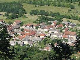
Ambléon (pronounced [ɑ̃.ble.ɔ̃]) is a French commune in the Ain department in the Auvergne-Rhône-Alpes region of eastern France.
The inhabitants of the commune are known as Ambléonais or Ambléonaises[1]
Geography
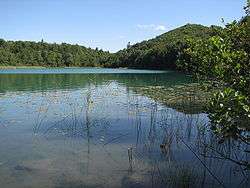
The village of Ambléon is located ten kilometres west of Belley and 60 km east of Lyon in a wetland (lakes, swamps, bogs) in the Bas-Bugey mountain range, 400 metres above sea level. The site is dominated by the Tentanet mountain (1019 m) on the slopes of which is the Lac d'Ambléon of glacial origin whose ecological interest is recognised.[2]
Access to the commune is by road D24 which branches from the D10 south of the commune (north of Premeyzel) and passes through the commune to the village then continues north to join the D41 just north of the commune. The D41 road comes from Saint-Germain-les-Paroisses in the north through the commune then passes near Lac d'Ambléon before continuing over the mountains west to join the D79 road near Lhuis. The D41 does not pass through the village but there is a connecting country road from it to the village. There are a few other small country roads in the commune. There is some farming activity along the D24 road but most of the commune is forested hills and mountains.[3]
The Serrin stream rises to the west of the village and passes through it before joining the Setrin stream which flows south through the commune to join the Gland stream south of the commune.[3]
Neighbouring communes and villages[3] | |
|---|---|
Administration
List of successive mayors of Ambléon[4]
| From | To | Name | Party | Position |
|---|---|---|---|---|
| 1947 | 1965 | Joannès Pezant | ||
| 1965 | 1983 | Jean Guillot | ||
| 1983 | 2008 | Henri Guillot | DVD | |
| 2008 | 2011 | Odette Breidenstein-Jullien | ||
| 2011 | 2020 | Annie Bionda | Postmistress |
(Not all data is known)
Demography
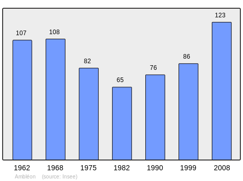
In 2009 the commune had 120 inhabitants. The evolution of the number of inhabitants is known through the population censuses conducted in the town since 1793. From the 21st century, a census of municipalities with fewer than 10,000 inhabitants is held every five years, unlike larger towns that have a sample survey every year.[Note 1]
| 1793 | 1800 | 1806 | 1821 | 1831 | 1836 | 1841 | 1846 | 1851 |
|---|---|---|---|---|---|---|---|---|
| 410 | 223 | 243 | 222 | 309 | 279 | 281 | 297 | 266 |
| 1856 | 1861 | 1866 | 1872 | 1876 | 1881 | 1886 | 1891 | 1896 |
|---|---|---|---|---|---|---|---|---|
| 254 | 223 | 223 | 205 | 191 | 213 | 200 | 200 | 206 |
| 1901 | 1906 | 1911 | 1921 | 1926 | 1931 | 1936 | 1946 | 1954 |
|---|---|---|---|---|---|---|---|---|
| 200 | 193 | 159 | 150 | 161 | 135 | 141 | 118 | 111 |
| 1962 | 1968 | 1975 | 1982 | 1990 | 1999 | 2006 | 2009 | - |
|---|---|---|---|---|---|---|---|---|
| 107 | 108 | 82 | 65 | 76 | 86 | 120 | 120 | - |
Sources : Ldh/EHESS/Cassini until 1962, INSEE database from 1968 (population without double counting and municipal population from 2006)
Economy
The Ambléon economy is based on agriculture (livestock and grain).
The town is located within the Appellation d'origine contrôlée (AOC) zone for the wines of Bugey.
Sites and monuments
- The Chateau of Ambléon (private residence)
- A Chapel (13th century)
- The War memorial to the maquis of Ambléon
Notable people linked to the commune
- Theodore Chavanton called Avanton, author of the folk novel The Lost Oasis (1945) and a teacher at the Ambléon school. His story takes place in Lombane (an anagram of Ambléon)
See also
External links
- Community of communes of Bugey Sud website (in French)
- Ambléon on Lion1906
- Ambléon on Google Maps
- Ambléon on Géoportail, National Geographic Institute (IGN) website (in French)
- Ambléon on the 1750 Cassini Map
- Ambléon on the INSEE website (in French)
- INSEE (in French)
Notes and references
Notes
- ↑ At the beginning of the 21st century, the methods of identification have been modified by law No. 2002-276 of 27 February 2002 Archived 2016-03-06 at the Wayback Machine., the so-called "law of local democracy" and in particular Title V "census operations" which allow, after a transitional period running from 2004 to 2008, the annual publication of the legal population of the different French administrative districts. For municipalities with a population greater than 10,000 inhabitants, a sample survey is conducted annually, the entire territory of these municipalities is taken into account at the end of the period of five years. The first "legal population" after 1999 under this new law came into force on 1 January 2009 and was based on the census of 2006.
References
- ↑ Inhabitants of Ain (in French)
- ↑ ZNIEFF for the Lac d'Ambléon. (in French)
- 1 2 3 Google Maps
- ↑ List of Mayors of France (in French)
| Wikimedia Commons has media related to Ambléon. |