Le Plantay
| Le Plantay | |
|---|---|
| Commune | |
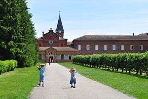 Abbey of Notre-Dame des Dombes | |
 Le Plantay Location within Auvergne-Rhône-Alpes region  Le Plantay | |
| Coordinates: 46°01′00″N 5°05′00″E / 46.0167°N 5.0833°ECoordinates: 46°01′00″N 5°05′00″E / 46.0167°N 5.0833°E | |
| Country | France |
| Region | Auvergne-Rhône-Alpes |
| Department | Ain |
| Arrondissement | Bourg-en-Bresse |
| Canton | Ceyzériat |
| Intercommunality | Chalamont |
| Government | |
| • Mayor (2008–2014) | Guy de Framond |
| Area1 | 19.96 km2 (7.71 sq mi) |
| Population (2008)2 | 535 |
| • Density | 27/km2 (69/sq mi) |
| Time zone | UTC+1 (CET) |
| • Summer (DST) | UTC+2 (CEST) |
| INSEE/Postal code | 01299 /01330 |
| Elevation |
267–286 m (876–938 ft) (avg. 275 m or 902 ft) |
|
1 French Land Register data, which excludes lakes, ponds, glaciers > 1 km2 (0.386 sq mi or 247 acres) and river estuaries. 2 Population without double counting: residents of multiple communes (e.g., students and military personnel) only counted once. | |
Le Plantay is a commune in the Ain department in eastern France.
Population
| Historical population | ||
|---|---|---|
| Year | Pop. | ±% |
| 1793 | 452 | — |
| 1800 | 336 | −25.7% |
| 1806 | 386 | +14.9% |
| 1821 | 383 | −0.8% |
| 1831 | 352 | −8.1% |
| 1836 | 338 | −4.0% |
| 1841 | 355 | +5.0% |
| 1846 | 422 | +18.9% |
| 1851 | 440 | +4.3% |
| 1856 | 455 | +3.4% |
| 1861 | 466 | +2.4% |
| 1866 | 551 | +18.2% |
| 1872 | 560 | +1.6% |
| 1876 | 589 | +5.2% |
| 1881 | 508 | −13.8% |
| 1886 | 556 | +9.4% |
| 1891 | 491 | −11.7% |
| 1896 | 538 | +9.6% |
| 1901 | 517 | −3.9% |
| 1906 | 485 | −6.2% |
| 1911 | 492 | +1.4% |
| 1921 | 441 | −10.4% |
| 1926 | 433 | −1.8% |
| 1931 | 432 | −0.2% |
| 1936 | 389 | −10.0% |
| 1946 | 399 | +2.6% |
| 1954 | 373 | −6.5% |
| 1962 | 323 | −13.4% |
| 1968 | 300 | −7.1% |
| 1975 | 281 | −6.3% |
| 1982 | 339 | +20.6% |
| 1990 | 344 | +1.5% |
| 1999 | 417 | +21.2% |
| 2008 | 535 | +28.3% |
Sights
The Abbey of Notre-Dame des Dombes, founded by Trappist monks in 1863, is located in the commune.
See also
References
External links
| Wikimedia Commons has media related to Le Plantay. |
This article is issued from
Wikipedia.
The text is licensed under Creative Commons - Attribution - Sharealike.
Additional terms may apply for the media files.