Les Neyrolles
| Les Neyrolles | |
|---|---|
| Commune | |
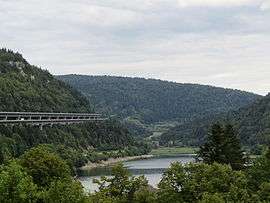 Sylans Lake | |
 Les Neyrolles Location within Auvergne-Rhône-Alpes region  Les Neyrolles | |
| Coordinates: 46°08′33″N 5°38′03″E / 46.1425°N 5.6342°ECoordinates: 46°08′33″N 5°38′03″E / 46.1425°N 5.6342°E | |
| Country | France |
| Region | Auvergne-Rhône-Alpes |
| Department | Ain |
| Arrondissement | Nantua |
| Canton | Nantua |
| Intercommunality | Lac de Nantua |
| Government | |
| • Mayor (2014–2020) | Lucien Juillard |
| Area1 | 9.5 km2 (3.7 sq mi) |
| Population (2014)2 | 638 |
| • Density | 67/km2 (170/sq mi) |
| Time zone | UTC+1 (CET) |
| • Summer (DST) | UTC+2 (CEST) |
| INSEE/Postal code | 01274 /01130 |
| Elevation |
510–1,118 m (1,673–3,668 ft) (avg. 625 m or 2,051 ft) |
|
1 French Land Register data, which excludes lakes, ponds, glaciers > 1 km2 (0.386 sq mi or 247 acres) and river estuaries. 2 Population without double counting: residents of multiple communes (e.g., students and military personnel) only counted once. | |
Les Neyrolles is a commune in the Ain department in eastern France.
Population
| Historical population | ||
|---|---|---|
| Year | Pop. | ±% |
| 1962 | 392 | — |
| 1968 | 383 | −2.3% |
| 1975 | 466 | +21.7% |
| 1982 | 526 | +12.9% |
| 1990 | 615 | +16.9% |
| 1999 | 617 | +0.3% |
| 2008 | 656 | +6.3% |
| 2014 | 638 | −2.7% |
See also
References
| Wikimedia Commons has media related to Les Neyrolles. |
This article is issued from
Wikipedia.
The text is licensed under Creative Commons - Attribution - Sharealike.
Additional terms may apply for the media files.