Arrondissement of Belley
| Belley | |
|---|---|
| Arrondissement | |
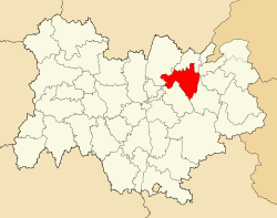 Arrondissement of Belley in Auvergne-Rhône-Alpes | |
| Country | France |
| Region | Auvergne-Rhône-Alpes |
| Department | Ain |
| Communes | 115 |
| Subprefecture | Belley |
| Area¹ | |
| • Total | 1,617 km2 (624 sq mi) |
| Population (2013) | |
| • Total | 118,783 |
| • Density | 73/km2 (190/sq mi) |
| ¹ French Land Register data, which exclude lakes, ponds, and glaciers larger than 1 km² as well as the estuaries of rivers. | |
The arrondissement of Belley is an arrondissement of France in the Ain department in the Auvergne-Rhône-Alpes region. Since the January 2017 reorganization of the arrondissements of Ain, it has 115 communes.[1]
Composition
Cantons
The cantons of the arrondissement of Belley are:
- Ambérieu-en-Bugey
- Bellegarde-sur-Valserine (partly)
- Belley
- Hauteville-Lompnes (partly)
- Lagnieu
- Meximieux (partly)
Communes
The communes of the arrondissement of Belley, and their INSEE codes, are:
- L'Abergement-de-Varey (01002)
- Ambérieu-en-Bugey (01004)
- Ambléon (01006)
- Ambronay (01007)
- Ambutrix (01008)
- Andert-et-Condon (01009)
- Anglefort (01010)
- Aranc (01012)
- Arandas (01013)
- Arboys-en-Bugey (01015)
- Argis (01017)
- Armix (01019)
- Artemare (01022)
- Belley (01034)
- Belmont-Luthézieu (01036)
- Bénonces (01037)
- Béon (01039)
- Bettant (01041)
- Blyes (01047)
- Bourg-Saint-Christophe (01054)
- Brégnier-Cordon (01058)
- Brénaz (01059)
- Brens (01061)
- Briord (01064)
- La Burbanche (01066)
- Ceyzérieu (01073)
- Chaley (01076)
- Champagne-en-Valromey (01079)
- Champdor-Corcelles (01080)
- Charnoz-sur-Ain (01088)
- Château-Gaillard (01089)
- Chavornay (01097)
- Chazey-Bons (01098)
- Chazey-sur-Ain (01099)
- Cheignieu-la-Balme (01100)
- Cleyzieu (01107)
- Colomieu (01110)
- Conand (01111)
- Contrevoz (01116)
- Conzieu (01117)
- Corbonod (01118)
- Corlier (01121)
- Cormaranche-en-Bugey (01122)
- Cressin-Rochefort (01133)
- Culoz (01138)
- Cuzieu (01141)
- Douvres (01149)
- Évosges (01155)
- Faramans (01156)
- Flaxieu (01162)
- Groslée-Saint-Benoît (01338)
- Hauteville-Lompnes (01185)
- Haut-Valromey (01187)
- Hostiaz (01186)
- Innimond (01190)
- Izieu (01193)
- Joyeux (01198)
- Lagnieu (01202)
- Lavours (01208)
- Leyment (01213)
- Lhuis (01216)
- Lochieu (01218)
- Lompnas (01219)
- Lompnieu (01221)
- Loyettes (01224)
- Magnieu (01227)
- Marchamp (01233)
- Marignieu (01234)
- Massignieu-de-Rives (01239)
- Meximieux (01244)
- Montagnieu (01255)
- Le Montellier (01260)
- Murs-et-Gélignieux (01268)
- Nivollet-Montgriffon (01277)
- Oncieu (01279)
- Ordonnaz (01280)
- Parves-et-Nattages (01286)
- Pérouges (01290)
- Peyrieu (01294)
- Pollieu (01302)
- Prémeyzel (01310)
- Prémillieu (01311)
- Rignieux-le-Franc (01325)
- Rossillon (01329)
- Ruffieu (01330)
- Saint-Champ (01341)
- Saint-Denis-en-Bugey (01345)
- Sainte-Julie (01366)
- Saint-Éloi (01349)
- Saint-Germain-les-Paroisses (01358)
- Saint-Jean-de-Niost (01361)
- Saint-Martin-de-Bavel (01372)
- Saint-Maurice-de-Gourdans (01378)
- Saint-Maurice-de-Rémens (01379)
- Saint-Rambert-en-Bugey (01384)
- Saint-Sorlin-en-Bugey (01386)
- Saint-Vulbas (01390)
- Sault-Brénaz (01396)
- Seillonnaz (01400)
- Serrières-de-Briord (01403)
- Seyssel (01407)
- Souclin (01411)
- Sutrieu (01414)
- Talissieu (01415)
- Tenay (01416)
- Thézillieu (01417)
- Torcieu (01421)
- Vaux-en-Bugey (01431)
- Vieu (01442)
- Villebois (01444)
- Villieu-Loyes-Mollon (01450)
- Virieu-le-Grand (01452)
- Virieu-le-Petit (01453)
- Virignin (01454)
- Vongnes (01456)
References
- ↑ "Arrêté n° 16-542, p 746" (PDF). Retrieved 2017-07-20.
External links
This article is issued from
Wikipedia.
The text is licensed under Creative Commons - Attribution - Sharealike.
Additional terms may apply for the media files.