Perrex
| Perrex | |
|---|---|
| Commune | |
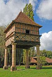 Dovecote | |
 Perrex Location within Auvergne-Rhône-Alpes region  Perrex | |
| Coordinates: 46°14′00″N 4°59′00″E / 46.2333°N 4.9833°ECoordinates: 46°14′00″N 4°59′00″E / 46.2333°N 4.9833°E | |
| Country | France |
| Region | Auvergne-Rhône-Alpes |
| Department | Ain |
| Arrondissement | Bourg-en-Bresse |
| Canton | Vonnas |
| Intercommunality | Pont-de-Veyle |
| Government | |
| • Mayor (2008–2014) | Bernard Daujat |
| Area1 | 11.1 km2 (4.3 sq mi) |
| Population (2008)2 | 836 |
| • Density | 75/km2 (200/sq mi) |
| Time zone | UTC+1 (CET) |
| • Summer (DST) | UTC+2 (CEST) |
| INSEE/Postal code | 01291 /01540 |
| Elevation |
179–213 m (587–699 ft) (avg. 200 m or 660 ft) |
|
1 French Land Register data, which excludes lakes, ponds, glaciers > 1 km2 (0.386 sq mi or 247 acres) and river estuaries. 2 Population without double counting: residents of multiple communes (e.g., students and military personnel) only counted once. | |
Perrex is a commune in the Ain department in eastern France.
Geography
The Veyle forms most of the commune's western border.
Population
| Historical population | ||
|---|---|---|
| Year | Pop. | ±% |
| 1962 | 522 | — |
| 1968 | 506 | −3.1% |
| 1975 | 520 | +2.8% |
| 1982 | 606 | +16.5% |
| 1990 | 714 | +17.8% |
| 1999 | 721 | +1.0% |
| 2008 | 836 | +16.0% |
See also
References
| Wikimedia Commons has media related to Perrex. |
This article is issued from
Wikipedia.
The text is licensed under Creative Commons - Attribution - Sharealike.
Additional terms may apply for the media files.