Ceyzériat
| Ceyzériat | ||
|---|---|---|
| Commune | ||
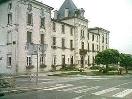 Town hall | ||
| ||
 Ceyzériat Location within Auvergne-Rhône-Alpes region  Ceyzériat | ||
| Coordinates: 46°10′44″N 5°19′26″E / 46.1788°N 5.3238°ECoordinates: 46°10′44″N 5°19′26″E / 46.1788°N 5.3238°E | ||
| Country | France | |
| Region | Auvergne-Rhône-Alpes | |
| Department | Ain | |
| Arrondissement | Bourg-en-Bresse | |
| Canton | Ceyzériat | |
| Intercommunality | La Vallière | |
| Government | ||
| • Mayor (2008–2014) | Jean-Yves Flochon | |
| Area1 | 9.36 km2 (3.61 sq mi) | |
| Population (2008)2 | 2,620 | |
| • Density | 280/km2 (720/sq mi) | |
| Time zone | UTC+1 (CET) | |
| • Summer (DST) | UTC+2 (CEST) | |
| INSEE/Postal code | 01072 /01250 | |
| Elevation |
240–585 m (787–1,919 ft) (avg. 338 m or 1,109 ft) | |
|
1 French Land Register data, which excludes lakes, ponds, glaciers > 1 km2 (0.386 sq mi or 247 acres) and river estuaries. 2 Population without double counting: residents of multiple communes (e.g., students and military personnel) only counted once. | ||
.svg.png)
Ceyzériat is a commune in the Ain department in eastern France.
History
Hippolyte Paul Jayr, twice minister during the July monarchy, was mayor of the commune at the end of the 19th century. The French archaeologist and assyriologist Maurice Pézard (1876–1923) died in this commune.
Population
| Historical population | ||
|---|---|---|
| Year | Pop. | ±% |
| 1793 | 1,039 | — |
| 1800 | 1,106 | +6.4% |
| 1806 | 1,012 | −8.5% |
| 1821 | 1,001 | −1.1% |
| 1831 | 1,041 | +4.0% |
| 1836 | 1,018 | −2.2% |
| 1841 | 981 | −3.6% |
| 1846 | 1,017 | +3.7% |
| 1851 | 1,046 | +2.9% |
| 1856 | 980 | −6.3% |
| 1861 | 987 | +0.7% |
| 1866 | 1,051 | +6.5% |
| 1872 | 1,058 | +0.7% |
| 1876 | 1,069 | +1.0% |
| 1881 | 1,029 | −3.7% |
| 1886 | 984 | −4.4% |
| 1891 | 966 | −1.8% |
| 1896 | 979 | +1.3% |
| 1901 | 939 | −4.1% |
| 1906 | 950 | +1.2% |
| 1911 | 918 | −3.4% |
| 1921 | 773 | −15.8% |
| 1926 | 828 | +7.1% |
| 1931 | 861 | +4.0% |
| 1936 | 809 | −6.0% |
| 1946 | 857 | +5.9% |
| 1954 | 1,037 | +21.0% |
| 1962 | 1,219 | +17.6% |
| 1968 | 1,503 | +23.3% |
| 1975 | 1,761 | +17.2% |
| 1982 | 1,956 | +11.1% |
| 1990 | 2,058 | +5.2% |
| 1999 | 2,390 | +16.1% |
| 2008 | 2,620 | +9.6% |
Its inhabitants are known as Ceyzériacois or Ceyzériolans.[1]
See also
References
- ↑ Gentilé de la commune, on habitants.fr
External links
| Wikimedia Commons has media related to Ceyzériat. |
This article is issued from
Wikipedia.
The text is licensed under Creative Commons - Attribution - Sharealike.
Additional terms may apply for the media files.