Lancrans
| Lancrans | |
|---|---|
| Commune | |
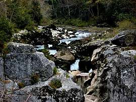 Pertes de la Valserine, canyon where the Valserine runs only underground | |
 Lancrans Location within Auvergne-Rhône-Alpes region  Lancrans | |
| Coordinates: 46°07′30″N 5°50′03″E / 46.125°N 5.8342°ECoordinates: 46°07′30″N 5°50′03″E / 46.125°N 5.8342°E | |
| Country | France |
| Region | Auvergne-Rhône-Alpes |
| Department | Ain |
| Arrondissement | Nantua |
| Canton | Bellegarde-sur-Valserine |
| Intercommunality | Bassin Bellegardien |
| Government | |
| • Mayor (2008–2014) | Pierre Gavin |
| Area1 | 9.66 km2 (3.73 sq mi) |
| Population (2008)2 | 1,025 |
| • Density | 110/km2 (270/sq mi) |
| Time zone | UTC+1 (CET) |
| • Summer (DST) | UTC+2 (CEST) |
| INSEE/Postal code | 01205 /01200 |
| Elevation |
350–1,606 m (1,148–5,269 ft) (avg. 625 m or 2,051 ft) |
|
1 French Land Register data, which excludes lakes, ponds, glaciers > 1 km2 (0.386 sq mi or 247 acres) and river estuaries. 2 Population without double counting: residents of multiple communes (e.g., students and military personnel) only counted once. | |
Lancrans is a commune in the Ain department in eastern France.
Population
| Historical population | ||
|---|---|---|
| Year | Pop. | ±% |
| 1962 | 891 | — |
| 1968 | 872 | −2.1% |
| 1975 | 836 | −4.1% |
| 1982 | 752 | −10.0% |
| 1990 | 815 | +8.4% |
| 1999 | 935 | +14.7% |
| 2008 | 1,025 | +9.6% |
See also
References
| Wikimedia Commons has media related to Lancrans. |
This article is issued from
Wikipedia.
The text is licensed under Creative Commons - Attribution - Sharealike.
Additional terms may apply for the media files.