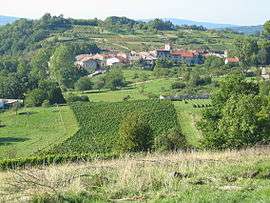
Mérignat
| Mérignat | |
|---|---|
| Commune | |
 | |
 Mérignat Location within Auvergne-Rhône-Alpes region  Mérignat | |
| Coordinates: 46°04′13″N 5°26′15″E / 46.0703°N 5.4375°ECoordinates: 46°04′13″N 5°26′15″E / 46.0703°N 5.4375°E | |
| Country | France |
| Region | Auvergne-Rhône-Alpes |
| Department | Ain |
| Arrondissement | Nantua |
| Canton | Pont-d'Ain |
| Intercommunality | Bugey-Vallée de l'Ain |
| Government | |
| • Mayor (2008–2014) | Eliane Zivkovic |
| Area1 | 3.17 km2 (1.22 sq mi) |
| Population (2008)2 | 136 |
| • Density | 43/km2 (110/sq mi) |
| Time zone | UTC+1 (CET) |
| • Summer (DST) | UTC+2 (CEST) |
| INSEE/Postal code | 01242 /01450 |
| Elevation |
300–587 m (984–1,926 ft) (avg. 385 m or 1,263 ft) |
|
1 French Land Register data, which excludes lakes, ponds, glaciers > 1 km2 (0.386 sq mi or 247 acres) and river estuaries. 2 Population without double counting: residents of multiple communes (e.g., students and military personnel) only counted once. | |
Mérignat is a commune in the Ain department in eastern France.
Population
| Historical population | ||
|---|---|---|
| Year | Pop. | ±% |
| 1962 | 122 | — |
| 1968 | 90 | −26.2% |
| 1975 | 86 | −4.4% |
| 1982 | 80 | −7.0% |
| 1990 | 85 | +6.2% |
| 1999 | 114 | +34.1% |
| 2008 | 136 | +19.3% |
See also
References
| Wikimedia Commons has media related to Mérignat. |
This article is issued from
Wikipedia.
The text is licensed under Creative Commons - Attribution - Sharealike.
Additional terms may apply for the media files.