Châtillon-sur-Chalaronne
| Châtillon-sur-Chalaronne | ||
|---|---|---|
| Commune | ||
 | ||
| ||
 Châtillon-sur-Chalaronne Location within Auvergne-Rhône-Alpes region  Châtillon-sur-Chalaronne | ||
| Coordinates: 46°07′00″N 4°58′00″E / 46.1167°N 4.9667°ECoordinates: 46°07′00″N 4°58′00″E / 46.1167°N 4.9667°E | ||
| Country | France | |
| Region | Auvergne-Rhône-Alpes | |
| Department | Ain | |
| Arrondissement | Bourg-en-Bresse | |
| Canton | Châtillon-sur-Chalaronne | |
| Government | ||
| • Mayor (2016–2020) | Patrick Mathias | |
| Area1 | 17.86 km2 (6.90 sq mi) | |
| Population (2014)2 | 4,956 | |
| • Density | 280/km2 (720/sq mi) | |
| Time zone | UTC+1 (CET) | |
| • Summer (DST) | UTC+2 (CEST) | |
| INSEE/Postal code | 01093 /01400 | |
| Elevation |
215–274 m (705–899 ft) (avg. 225 m or 738 ft) | |
|
1 French Land Register data, which excludes lakes, ponds, glaciers > 1 km2 (0.386 sq mi or 247 acres) and river estuaries. 2 Population without double counting: residents of multiple communes (e.g., students and military personnel) only counted once. | ||
.svg.png)
Châtillon-sur-Chalaronne is a commune in the Ain department in eastern France.
History
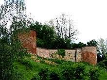
The town is home to a castle built around 1000 AD.
The town was formerly named Châtillon-les-Dombes.
Geography
The Chalaronne flows northwest through the commune and crosses the town.
Population
| Historical population | ||
|---|---|---|
| Year | Pop. | ±% |
| 1793 | 2,179 | — |
| 1800 | 3,119 | +43.1% |
| 1806 | 3,194 | +2.4% |
| 1821 | 2,759 | −13.6% |
| 1831 | 2,638 | −4.4% |
| 1836 | 2,814 | +6.7% |
| 1841 | 3,236 | +15.0% |
| 1846 | 3,424 | +5.8% |
| 1851 | 3,533 | +3.2% |
| 1856 | 2,874 | −18.7% |
| 1861 | 3,004 | +4.5% |
| 1866 | 3,046 | +1.4% |
| 1872 | 2,763 | −9.3% |
| 1876 | 3,090 | +11.8% |
| 1881 | 2,890 | −6.5% |
| 1886 | 2,840 | −1.7% |
| 1891 | 2,956 | +4.1% |
| 1896 | 2,813 | −4.8% |
| 1901 | 2,902 | +3.2% |
| 1906 | 2,901 | −0.0% |
| 1911 | 2,858 | −1.5% |
| 1921 | 2,660 | −6.9% |
| 1926 | 2,732 | +2.7% |
| 1931 | 2,653 | −2.9% |
| 1936 | 2,606 | −1.8% |
| 1946 | 2,474 | −5.1% |
| 1954 | 2,493 | +0.8% |
| 1962 | 2,608 | +4.6% |
| 1968 | 2,678 | +2.7% |
| 1975 | 3,241 | +21.0% |
| 1982 | 3,518 | +8.5% |
| 1990 | 3,786 | +7.6% |
| 1999 | 4,137 | +9.3% |
| 2008 | 4,924 | +19.0% |
Twin towns
- Wächtersbach (Germany)
- Colceag (Romania)
Personalities
- Saint Vincent de Paul: was curate of Châtillon and founded the Brotherhood of Charity (1617)
- Philibert Commerson: botanist, born in Châtillon in 1727
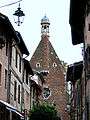
Church 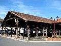
Historic market hall 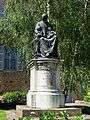
Monument Vincent de Paul
See also
References
External links
| Wikimedia Commons has media related to Châtillon-sur-Chalaronne. |
- Châtillon-sur-Chalaronne official website
- La Dombes and Châtillon-sur-Chalaronne
- Images by Paul C. Maurice
This article is issued from
Wikipedia.
The text is licensed under Creative Commons - Attribution - Sharealike.
Additional terms may apply for the media files.