Saint-Roman-de-Codières
| Saint-Roman-de-Codières | ||
|---|---|---|
| Commune | ||
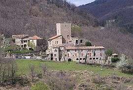 A general view of Saint-Roman-de-Codières | ||
| ||
 Saint-Roman-de-Codières Location within Occitanie region  Saint-Roman-de-Codières | ||
| Coordinates: 44°00′11″N 3°46′41″E / 44.0031°N 3.7781°ECoordinates: 44°00′11″N 3°46′41″E / 44.0031°N 3.7781°E | ||
| Country | France | |
| Region | Occitanie | |
| Department | Gard | |
| Arrondissement | Le Vigan | |
| Canton | Le Vigan | |
| Intercommunality | Cévennes Gangeoises et Suménoises | |
| Government | ||
| • Mayor (2008–2014) | Philippe Pibarot | |
| Area1 | 18.43 km2 (7.12 sq mi) | |
| Population (2008)2 | 172 | |
| • Density | 9.3/km2 (24/sq mi) | |
| Time zone | UTC+1 (CET) | |
| • Summer (DST) | UTC+2 (CEST) | |
| INSEE/Postal code | 30296 /30440 | |
| Elevation |
280–981 m (919–3,219 ft) (avg. 630 m or 2,070 ft) | |
|
1 French Land Register data, which excludes lakes, ponds, glaciers > 1 km2 (0.386 sq mi or 247 acres) and river estuaries. 2 Population without double counting: residents of multiple communes (e.g., students and military personnel) only counted once. | ||

Saint-Roman-de-Codières is a commune in the Gard department in southern France.
Population
| Historical population | ||
|---|---|---|
| Year | Pop. | ±% |
| 1793 | 1,009 | — |
| 1800 | 656 | −35.0% |
| 1806 | 948 | +44.5% |
| 1821 | 908 | −4.2% |
| 1831 | 925 | +1.9% |
| 1836 | 951 | +2.8% |
| 1841 | 921 | −3.2% |
| 1846 | 882 | −4.2% |
| 1851 | 870 | −1.4% |
| 1856 | 907 | +4.3% |
| 1861 | 761 | −16.1% |
| 1866 | 783 | +2.9% |
| 1872 | 701 | −10.5% |
| 1876 | 660 | −5.8% |
| 1881 | 653 | −1.1% |
| 1886 | 608 | −6.9% |
| 1891 | 561 | −7.7% |
| 1896 | 545 | −2.9% |
| 1901 | 515 | −5.5% |
| 1906 | 509 | −1.2% |
| 1911 | 501 | −1.6% |
| 1921 | 451 | −10.0% |
| 1926 | 404 | −10.4% |
| 1931 | 350 | −13.4% |
| 1936 | 314 | −10.3% |
| 1946 | 274 | −12.7% |
| 1954 | 233 | −15.0% |
| 1962 | 198 | −15.0% |
| 1968 | 132 | −33.3% |
| 1975 | 138 | +4.5% |
| 1982 | 147 | +6.5% |
| 1990 | 134 | −8.8% |
| 1999 | 180 | +34.3% |
| 2008 | 172 | −4.4% |
See also
References
| Wikimedia Commons has media related to Saint-Roman-de-Codières. |
This article is issued from
Wikipedia.
The text is licensed under Creative Commons - Attribution - Sharealike.
Additional terms may apply for the media files.